


Study „Mapping Urban Areas of Bosnia and Herzegovina Under the Torrential Flood Risk and Preliminary Assessment of Protection Measures Application Based on Nature-Inspired Solutions in the Area of the City of Banja Luka and the City of Tuzla”
Investor: United Nations Development Programme, BiH
Implementation period: November 2021 - March 2022
- Introduction
Numerous studies dealing with natural hazards imply terrifying statistics saying that natural hazards intensity is increasing over the years, and frequency is getting more expressed. Within this frame consequences are getting bigger regarding damages to material property and loss of lives.
Less attention is dedicated to torrential floods, since they occur in smaller river basins without hydrological monitoring, as well as regarding the fact that methodology for investigations is far more complex due to character of the torrential phenomenon.
Due to very destructive actions of torrential floods, the question about the status in the field of torrential flooding risk in Bosnia and Herzegovina is justified. It is the same regarding scenario of torrential flood occurrence in future and measures that should be planed and implemented.
Main goal of the Study is development of the appropriate methodological approach for identifying potential risk of torrential flooding in the first phase, and in the next phases to identify innovative measures of protection based on natural solutions contributing planned struggle against torrential flooding and its consequences.
Key difference between those two pilot areas (the City of Banja Luka and the City of Tuzla) is that for Vrbas river basin in BiH, the document under the title Identification of torrential river basins and establishment of the vulnerability module to the occurrence and propagation of torrential flooding, with map of erosion in the Vrbas river basin was developed as part of the project Flood hazard maps and flood risk maps for the Vrbas river basin in BiH.
Respecting above-mentioned differences in previously implemented investigation activities for fulfilling the ultimate goal – development of maps with spatial presentation of hazards and risk of torrential flooding, the Methodology for those two pilot areas i.e. for each city urban area with solid and modest fond of data basically differ:
- Area of the city of Tuzla – area with modest data fond → I Part: Methodology for identification of torrential river basins and establishing vulnerability model to the occurrence and development of torrential flooding + II Part: Methodology for mapping hazards and risks of torrential flooding,
- Area of the city of Banja Luka – area with series data fond → II Part:
Goal of the Study is defining methodology, analysing and mapping the risk of torrential flooding from small urban and suburban watercourses of torrential nature in pilot areas of the Banja Luka and the Tuzla.
The Preliminary analyses of applied protection measures was performed based on nature-inspired solutions for the Pilot areas (three torrential river basins for the each of the cities, i.e Banja Luka and Tuzla).
Component parts of the Study on mapping the risks of torrential flooding in urban areas in Bosnia and Herzegovina with preliminary assessment of applied protection measures based on nature-inspired solutions were completed within the period of 3 months:
- Initial Report – analyses of river basins in context of risk assessment with development of required maps,
- Draft of the Study – development of methodology and simplified hydraulic models on identified torrential river basins,
- Study – final version – mapping and estimation of the risk of torrential flooding on identified river basis with development of the geospatial basis, and
- Annex to the Contract for the additional period of one month from the date of the Final Study submission (based on the original contract) covered implementation of activities on development of Flood hazard and Flood risk maps for torrential flooding on three selected torrential river basins within the Tuzla territory, with defining preliminary adaptation measures and reduction of harmful consequences of flooding by application of nature-based solutions.
- Development of required methodologies
All the necessary terrain investigations of the torrential river basis/torrential watercourses have been explained in details within the Draft study as well as methodological approach to development of following:
- Cadastre/register of the torrential watercourses/river basins,
- Model of vulnerability to occurrence and development of torrential flooding,
- Mapping of water erosion intensity, and
- Mapping of torrential flood hazard and flood risk.
Methodology for analysing hazard and risk of flooding on bigger watercourses has been analysed and upgraded with this Study, including analyses of nature of torrential floods (fast occurrence and sudden flood wave propagation, followed with strong flow regime and different production of all type of sediment).
Apart of all stated elements, respecting the character of torrential flooding which is amongst all, firstly characterized by sediment (bed load, suspended and floating) introducing additional elements is of the key importance for consideration of the flooding risk:
- Calculation of tractive force (tangential stress) in the main river bed and river valley ( it is of key importance from the aspect of the river bed and banks erosion and movement and deposition of sediment) and
- Mapping of spatial distribution and coverage of all active landslides on certain torrential river basin (with the special accent to active landslides in immediate narrower and wider area of torrential courses, whose movement can create changes in discharge profile of the main riverbed and its possible partition and transport of significant quantities of the slipped material thought the torrential flow riverbed).
- Map of Torrential flooding hazards:
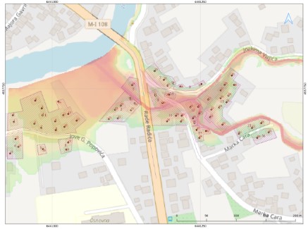
Formula for calculating the value of flooding hazard on bigger watercourses remains the same even in the case of mapping the hazard of torrential flooding but for the torrential watercourses additional map of calculated tangential stress is being introduced (considering the granulometric composition of the riverbed of the torrential watercourse and deposition of sediment) as one of the basic indicator of possibility of river sediment transport, i.e process of erosion and deposition of river material, and map of active landslides on torrential river basin, Figure 3.1

Transport of sediment is being additionally analysed through:
- Map of tangential stress considering the character of torrential flooding (landslides and deposition of the sediment),
- Map of erosion of the river bed and deposition of sediment, and
- Map of active landslides at certain torrential river basin.
Analyses of previously implemented measures on each of analysed torrential river basins in order to estimate resistance index (segment of erosion and deposit transport) as well as assumption that all of the implemented measures are in functional status and full capacity (regular maintenance).
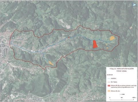
- Results of testing the Methodology for selecting the torrential river basins and establishment of the model of vulnerability to the occurrence and development of the torrential flooding – Jala river basin – City of Tuzla
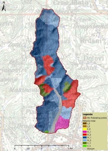
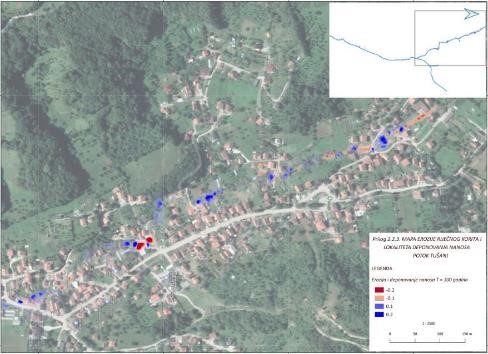
- Map of erosion of Jala river basin
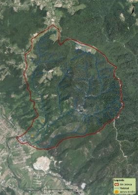
Subject of investigation activities is analyses of the recent status of erosion processes, i.e. investigation of the scope of activities and intensity of the water erosion within Jala river basin. Therefore, basic goal is to identify and objectively review existing status and spatial organization of erosion categories (strength of erosion process) in the area of Jala river basin, and to create base for quality and quantity presentation of erosion volume.
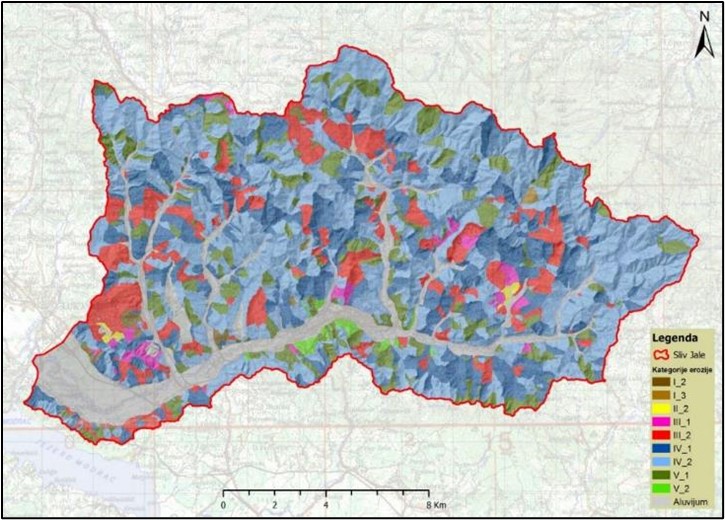
During consideration of erosion process on the Jala river slopes, numerous landslides have been considered as one of most significant processes on the slopes.
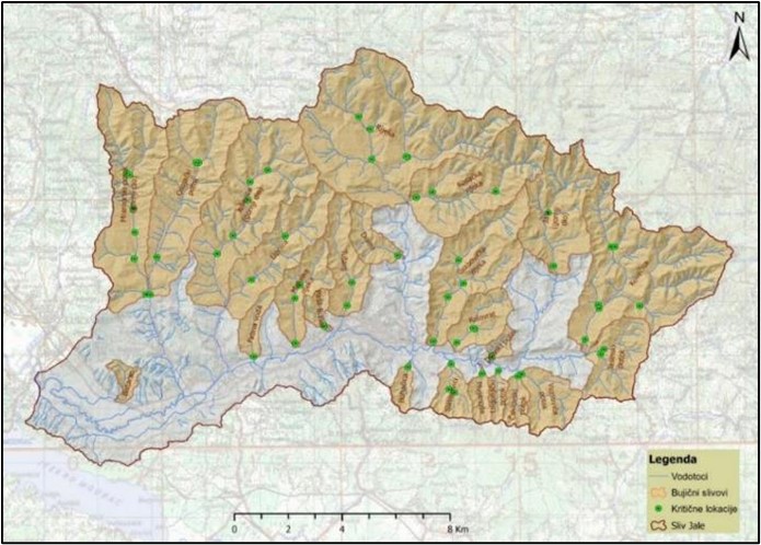
- Identification of the torrential river basins in the Jala river basin – Cadastre/register of torrential river basins
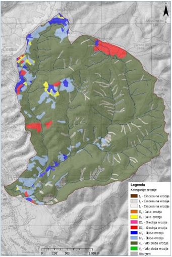
In this investigation, in the Jala river basin, there are 24 torrential (sub) basins. Total surface of identified torrential (sub) basin within Jala river basin is 166.09 km2. Special attention in identification of torrential river basins is dedicated to basins where »critical locations« prevail, i.e. places were water and sediment cause biggest problems and damages on existing residential or business buildings, as well as problems in traffic.
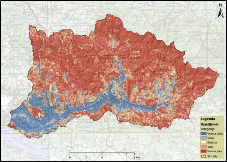
- Model of vulnerability to the occurrence and propagation of the torrential floods in Jala river basin
According to results of model of vulnerability to the occurrence and propagation of torrential floods in the Jala river basin, 73.46% of the Jala river basin surface is within category of the strong and very strong vulnerability to the occurrence and propagation of torrential flooding. If the spatial distribution of categories of very strong and strong vulnerability to the occurrence and development of torrential floods is considered, it can be concluded that they correspond to basins where, considering intensity of erosion processes and other relevant factors, it is realistic to expect occurrence of torrential flooding.
Draft Study presents actions, analyses and results of erosion processes, hydrological and hydraulic analyses and analyses of sediment transport toward stated methodology in details for mapping the torrential flood hazards and risks, for three typical torrential river basins for each of Pilot areas in the city of Tuzla and the city of Banja Luka, Figures 5.1 and 5.2:
| · The City of Tuzla:o Kovačica stream,
o Tušanj stream and o Osojački (Dobrnjski) stream. |
· The City of Banja Luka:o Rebrovački stream,
o Jelovac stream and o Mali Ularac stream. |
Description of all implemented activities at the level of:
- Analyses of each individual torrential river basin,
- Hydrological analyses,
- Description of erosion processes in the river basin,
- Hydraulic analyses.
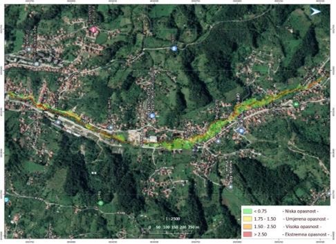
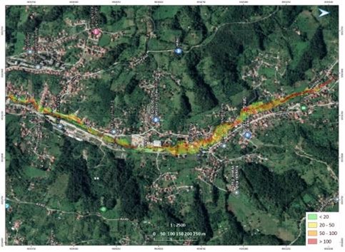
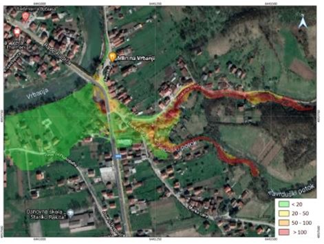
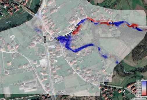
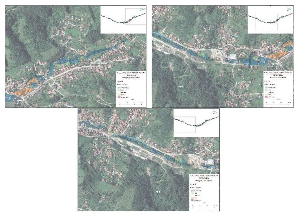
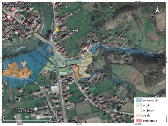
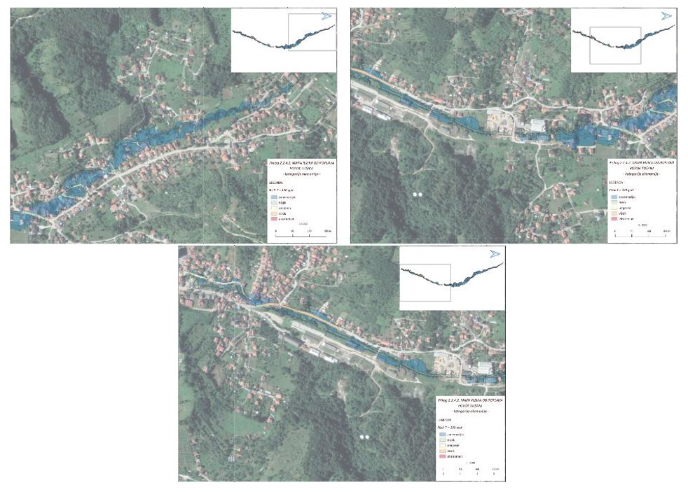
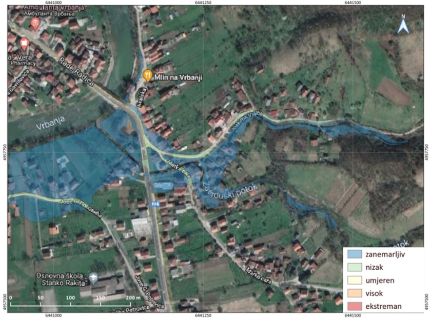
are described in details at the level of the Final Studies of torrential flood hazard and risk mapping. Results of flood mapping on the Tušanj stream within the Jala river basin in Tuzla and Jelovac stream within Vrbanja river basin in Banja Luka are attached as Figures 5.3. -5.12.
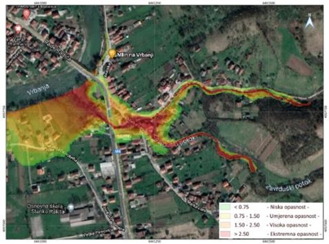
- Flood risk Maps for the area of analysed torrential river basins in Tuzla and Banja Luka
In order to get results in the form of Flood risk maps it was necessary to acquire all the available information about material and cultural assets which are represented in detailed list of assets exposed to the risk.
For the basin of all considered torrential streams in Tuzla and Banja Luka, all the risks for population and economic category have been calculated for all three designed flood events. Only exception is on the Mali Ularac river basin in the city of Banja Luka, where the risk of flooding of cultural and historical heritage was calculated.
On Figures 6.3.-6.4. the flood risk for the category of population on the example of the flood risk of Tušanj stream in Tuzla and Jelovac stream in Banja Luka, and Figures 6.5-6.6. present risk of flooding to the economic categories. Economic flood risk category is calculated based on cumulative risks to economic subjects, agriculture and traffic infrastructure.
- Preliminary assessment for applying the adaptation measures based on nature-inspired solutions for the analysed areas of torrential river basins in Tuzla and Banja Luka
Investigation indicate, that if the planning model of urban area is not changed and if the surface runoff is not made more efficient, problems with flooding will get even more unfavourable. Traditional systems which were previously designed for urban runoff drainage had a purpose to transport the runoff as fast as possible to the recipient, without dealing with extreme situations of heavy precipitations and preserving the quality of extreme runoffs and flooding before it’s introduced to recipient.
Since the flooding caused by bigger watercourses occupies adequate attention, it is necessary to turn attention to the flooding by torrential water courses on urban and sub-urban areas, where two types of flooding occur: · flooding by smaller hilly torrential courses and · flooding caused by heavy precipitation in urban centres due to exceeding previously designed capacities of the rain sewerage.
Strategic frameworks and preliminary analyses of possible measures were presented in the Study within the nature-inspired solutions and their general applicability to considered project areas.
In this innovated approach toward protection, nature based solutions occurred as efficient and functional tool for providing systematic answers to such challenges, Figure 7.1.
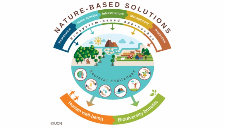
NBS is term used for innovative, nature-based processes and eco systems, for solving different types of social and environmental challenges (Ruangpan, et al., 2020). Reason for introducing it, is that they offer possibility of close cooperation with nature in adjusting to the future changes, they reduce impacts of climate changes and improve human wealth (Cohen-Shacham, et al., 2016).
Nature-based solutions term is established in late 2000’s in context of inventing new solutions for adaptation and mitigation of climate changes, covering protection of biodiversity and sustainable life. There are several definitions used in international scientific community, and two most distinguished are definition of International Union for Conservation of Nature (IUCN) and European Commission (EC).
It is important to conclude that considered measures presented in the preliminary catalogue do not cover active landslide with deep sliding planes, but just surface erosion, i.e. erosion control measures.
Respecting the specific features of considered torrential basins in Tuzla (size of the basin, flood risks, “bottle neck” impacts to constructed objects in river channels, limitation due to position of residential and other objects within the flood planes, impacts of surface erosion etc.) there is list with applied urgent and interim measures referring to mitigation of torrential flood risks and erosion control, selected by priorities on considered river basins.