


Preliminary and Detailed Designs Increasing the Capacity of the Trebisnjica River Channel in the Urban Area of the City
(Institute for Water Management, Bijeljina, 2021)
The ‘Trebisnjica’ hydrosystem (HET) is one of the largest and most complex integrated water management systems in Southern Europe and is the largest development project in Eastern Herzegovina. The main facilities are Bileca and Trebinje multi-purpose reservoirs, which also have the role of active flood protection in the valley downstream from the Trebinje reservoir. This flood control area also includes the city of Trebinje. Popovo Polje, which is further downstream, cannot be defended from flooding during extreme flood waves but flooding can be partially mitigated by optimum management of the reservoirs.
Prior to the construction of the HET hydrosystem, traditional and careful construction rules were followed in the Trebisnjica valley, allowing construction only in the areas out of the reach of the maximum flood level. Given this cautious approach, there was no damage during one-hundred-year floods and even those of rarer return periods. After the construction of the reservoirs, a deceptive feeling of protection from floods was created downstream. Despite the warnings of the HET, buildings were constructed lower and lower, even in the main river channel of the Trebisnjica. This irresponsible behavior, which was not stopped by the authorities, was further accelerated after the construction of the Capljina PS HPS. At that time, despite many warnings that Popovo Polje was not completely protected from floods, proprietors thought that they were no longer in danger of flooding. They ignored a key fact: dangerous precipitation cyclones affect both the Trebisnjica and Neretva basins at the same time, causing simultaneous flood flows at both rivers. The water licence issued for the construction of the Capljina PS HPS defined the following restriction: when the flow rates in the Neretva exceed 1,400m3/s, the hydroelectric power station may not operate its turbines. At this stage, there is almost no outflow from Popovo Polje. Therefore, in the event of extremely unfavourable precipitation cyclones, partial flooding of the polje cannot be prevented, despite the optimum management of the HET reservoirs. The following conclusion is important: the design of both HET and Capljina PS HPS clearly emphasized a warning that the riparian area of the Trebisnjica and downstream poljes can be protected from floods only to a limited extent.
Despite the warnings, uncontrolled construction in the riparian area and even the main river channel in Trebinje reduced the channel capacity from about 1,000m3/s to about 350m3/s. This greatly reduced the space for the normal operation of HET facilities using the criteria with which the system was planned. Therefore, the management rules must be changed. Due to increasing management constraints, the production of HET and the power system suffer large damages. Also, the damage caused in the areas of uncontrolled construction in the river valley cannot be avoided.
Preliminary and detailed designs for increasing the channel capacity of the Trebisnjica analysed and proposed technical solutions according to the requirements of the new water permit, to a level that provides reduction of flood damage, improvement of conditions for planning electricity production, and operation of facilities in the HET system.
Technical solutions that provide increased flow rate, priorities and phasing of structural measures were proposed for conditions of significant spatial constraints, with the aim that the planned facilities do not disrupt the connection of the urban area of Trebinje with the water area. The solutions retain and better fit some sports and recreational facilities in the riparian area, and to some extent, improve the visual aspect of the valley caused by illegal construction within the public water body.
Level of Protection
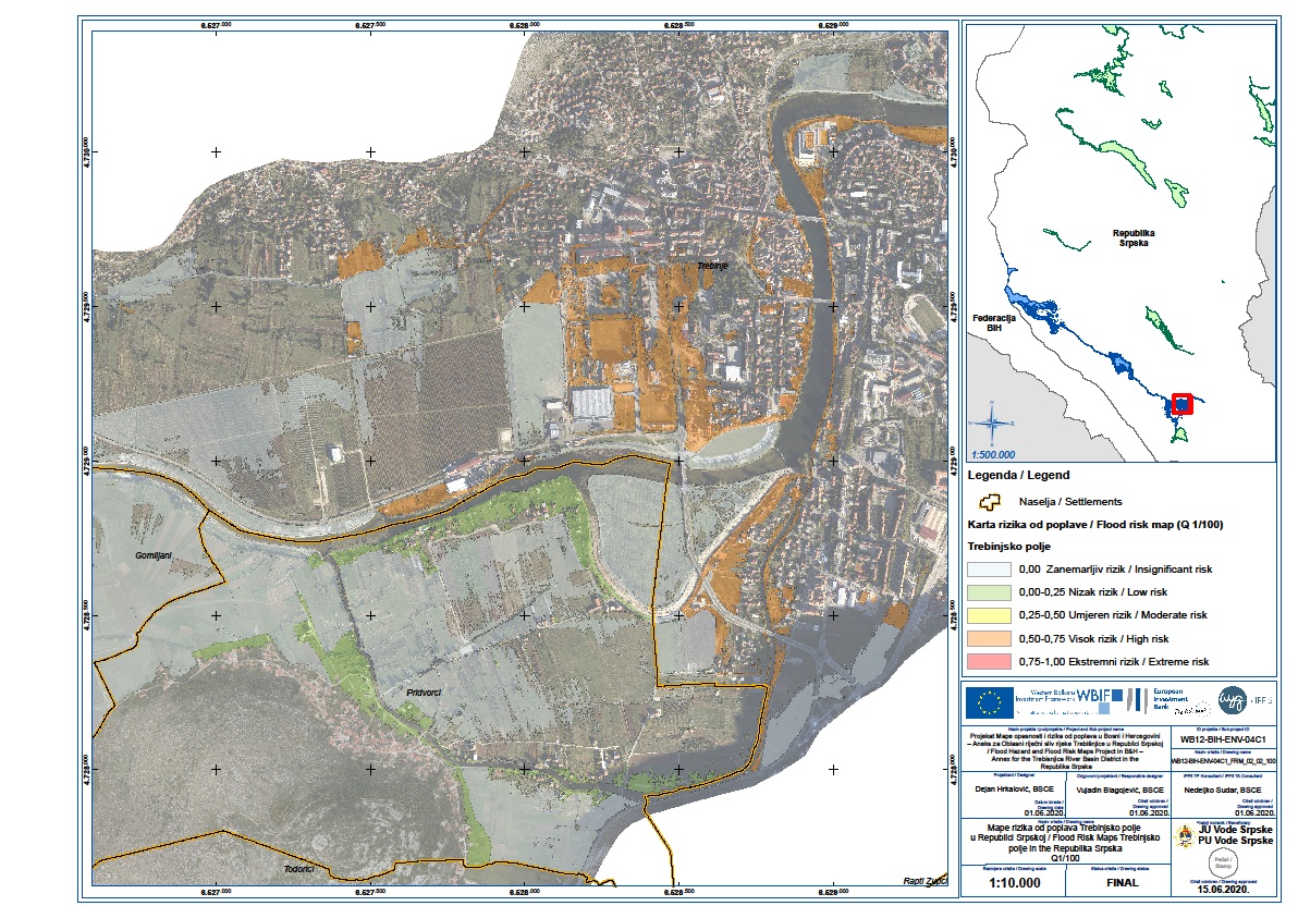
In order to decide on the level of protection, we elaborated the project solutions at the level of a detailed design and carried out additional hydraulic analyses of the regulated Trebisnjica river channel. We took into account the situation on the ground, realistic possibilities, and technical and economic feasibility. The level of protection specifies the elevation of the embankment crest on the left bank of the Trebisnjica and of the flood defence wall along the Pridvoracki branch in the area affected by back water of the Trebisnjica:
- The design level of the embankment crest: Z1/100+50cm;
- The design level of the flood defence wall crest: Z1/100.
In addition to the criteria of stability of the designed embankments and flood defence walls, the technical basis for selecting this level of protection is also a compromise between urban planning and flood protection (Figure 2).
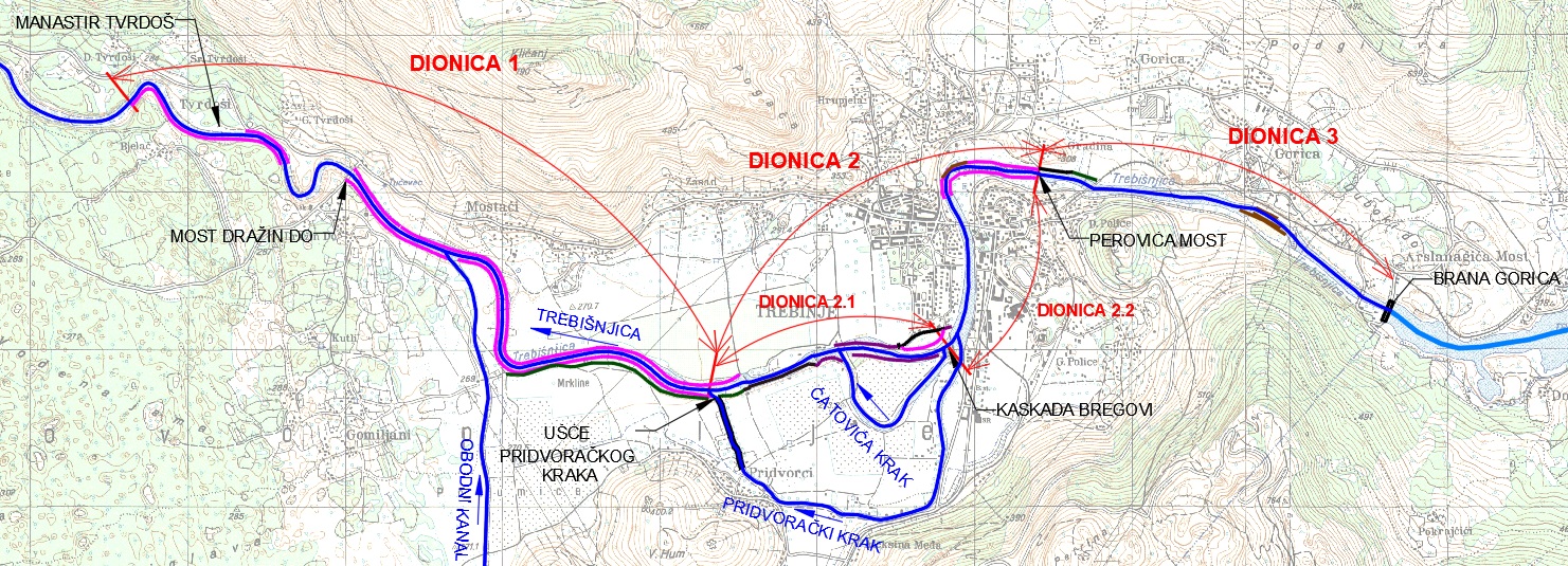
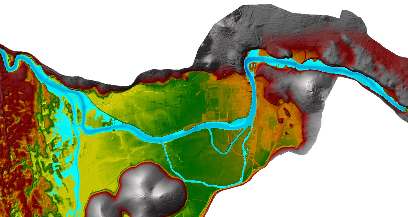
The mathematical hydraulic model in the wider project area included a 11km stretch of the Trebisnjica downstream of the Gorica dam (including the Pridvoracki and Catovica branch), and inflows from the Main Perimeter Canal from Mokro/Petrovo Polje, as well as surface runoff from urban and suburban areas. Three characteristic sections are clearly distinguished in this stretch of the Trebisnjica, taking into account the impact of flood flow regimes and also potential considerations for improvement of the river channel to increase its capacity (Figure 3).
Hydraulic Modelling
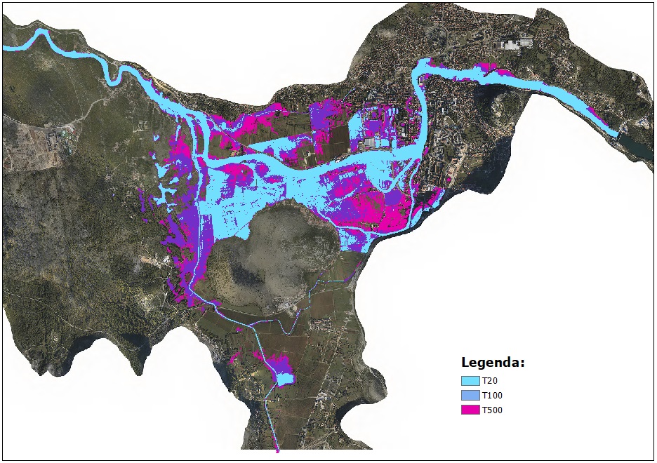
The results of mathematical modelling and the developed mathematical hydraulic model provided key observations on the basis of which targeted measures are predicted that will have an impact on reducing flood risk in the project area.The results of hydraulic analyses of flood flows largely agree with the previous analyses carried out in 2013 and with the results of preliminary hydraulic calculations carried out for this project. Figure 4 shows results of hydraulic analyses for the design floods of T20, T100 and T500 return periods in the existing state.
Hydraulic analyses of the regulated state, carried out within the detailed design, defined a flood and depth map which takes into account the positions of linear flood defences (areas of permitted flow were entered into the mathematical model after excluding flooding of the wide river valley protected by embankments and flood defence walls), as well as designed rubber dams and shortening of the existing weir in the area of Rupe (Figure 5).
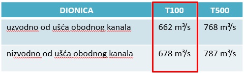
Tables 1 - 3 show the expected hydraulic effects of the planned flood risk mitigation measures, which were defined during the development of the Preliminary Design, and which were modified to a lesser extent after detailed hydraulic analyses in the Detailed Design.
Multi-Criteria Ranking of Structural Measures
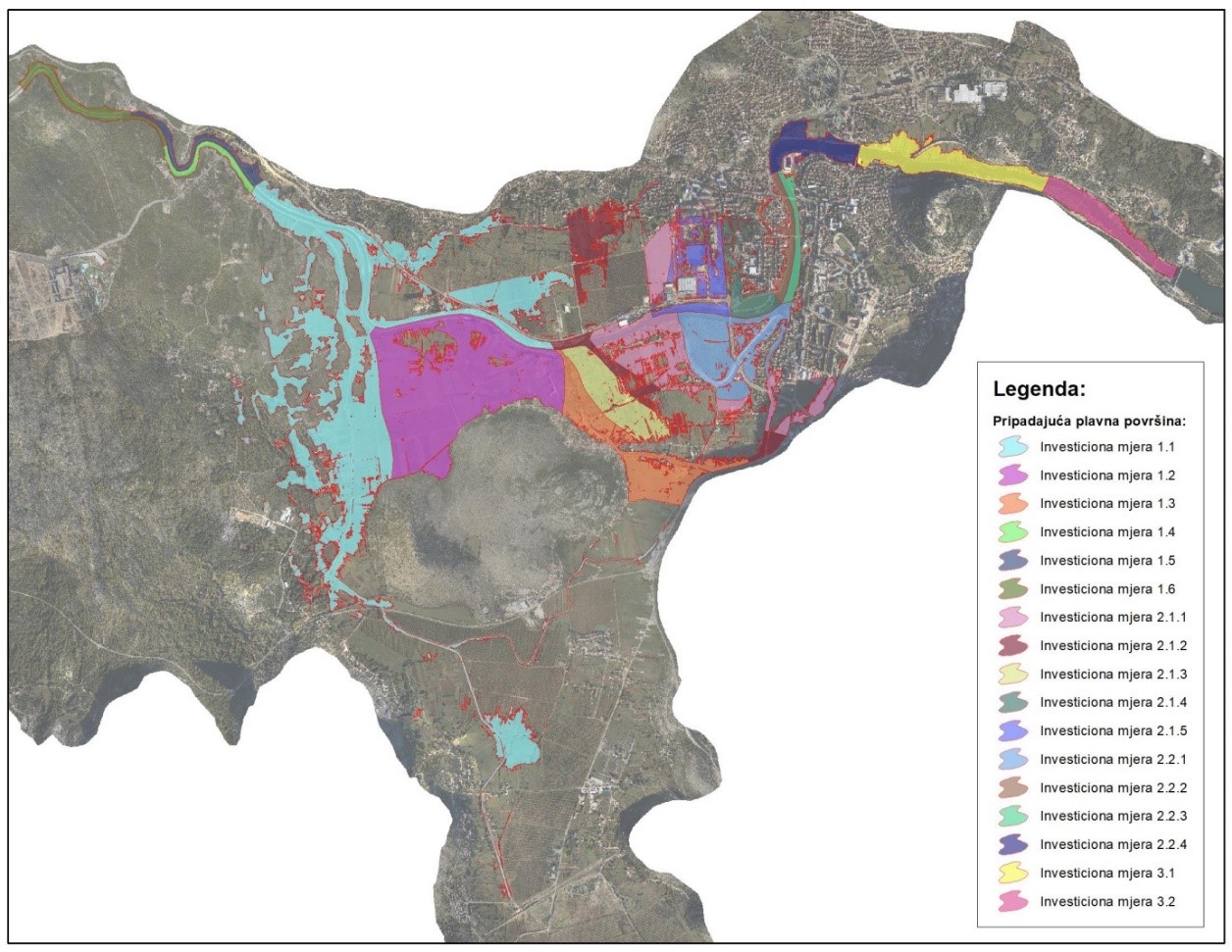
Based on the flood hazard maps and socio-economic categories in the potential flood area and on the basis of previously prepared flood risk maps, the estimated potential damage was one of the key indicators in the multi-criteria analysis, where the flood risk was spatially defined and harmonized with the planned structural measures (Figure 6 and 7).
All criteria for making decisions on the evaluation of structural measures were selected as:
Objective:
- Value of investment costs of structural measures (BAM);
- The effect of increasing the channel capacity of the Trebisnjica (∆Q and ∆h) for a certain structural measure;
- Effects of flood risk reduction and assessment of avoided flood damage (BAM) for a certain structural measure;
Non-qualitative / qualitative:
- Matching the structural measure to phased construction and development plans of the City of Trebinje;
- Impact of a structural measure on environment; and
- Benefits and limitations - resolved property rights for the implementation of the structural measure.
TECHNICAL SOLUTIONS – STRUCTURAL MEASURES FOR FLOOD RISK REDUCTION
Although the increase of the channel capacity of the Trebisnjica refers to the urban part of the city, hydraulic analyses and structural measures are planned for a wider area, because there is an evident need for partial and phased solution of flood risk reduction in the City of Trebinje.
A significant number of different structural projects (technical solutions) in the main river channel and valley is designed.
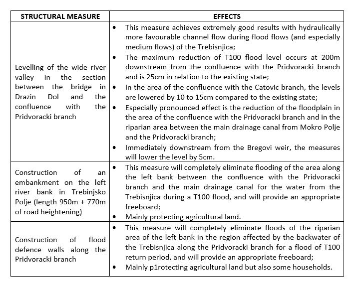
According to the technical concept, the two following key goals will be achieved in Section 1:
- Increasing the channel capacity of the Trebisnjica by widening the river valley from the bridge in Drazin Dol to the confluence with the Pridvoracki branch; and
- Formation of a protected area on the left bank of the Trebisnjica which will be bordered by two structures:
- Flood defence walls along the Pridvoracki branch (protection against flooding from the Pridvoracki branch in the section affected by backwater flooding of the Trebisnjica);
- Embankment on the left river bank of the Trebisnjica.
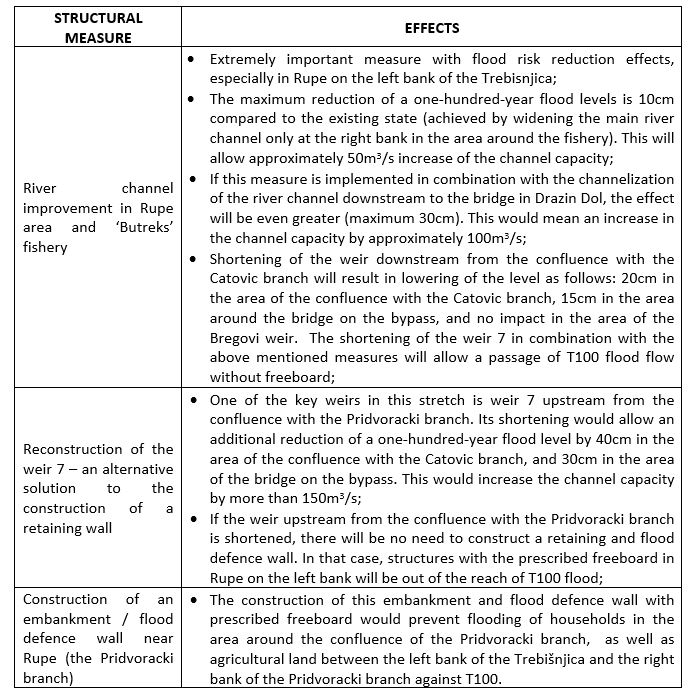
Taking into account the concept, structural measures in Section 2.1 are divided into three basic groups:
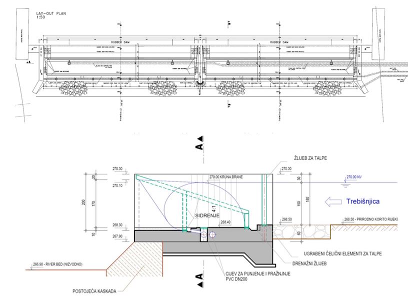
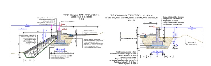
- Channelization of the main river channel and shortening the weirs 6, 7 and 8, including construction of variable weirs 8 and 6 with accompanying works in the main river channel (Figure 8);
- Widening and stabilization of the main river channel between the weirs 7 and 6, including widening and stabilization at the site of Butrex fishery; and
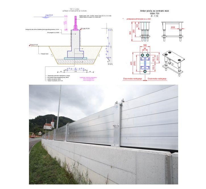
- Construction of flood defence walls along the main river channel, levelling and management of a wide river valley with accompanying works (Figure 9).
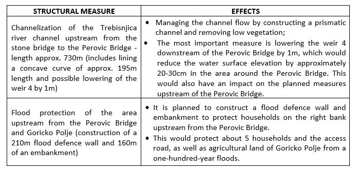
According to the technical concept, the two following key goals will be achieved in Section 2.2:
- Stabilization and levelling of the banks of the main river channel from the weir in Bregovi to the Ivo Andric Bridge;
- Channelization of the main river channel and stabilization of the right bank (concave curve downstream from the weir 4);
- Increasing the channel capacity of the Trebisnjica by increasing cross-sectional conveyance capacity of the main channel.
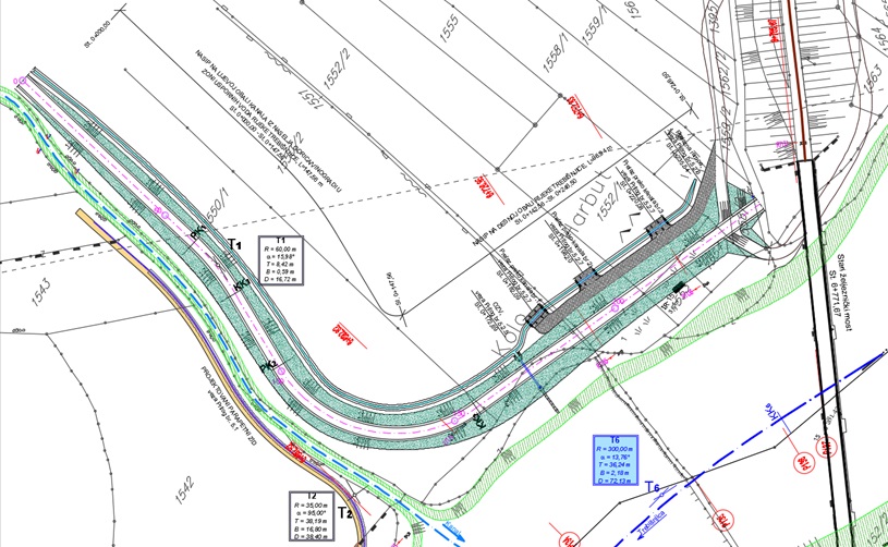
It is evident that in Section 3 (between the Perovic Bridge and the Old Railway Bridge) the key floods are on the right bank. Therefore, according to the technical concept, the two following key goals will be achieved:
- Formation of a protected area on the right bank of the Trebisnjica between the Perovic Bridge and the Old Railway Bridge, which will be bordered by two structures:
- Flood defence walls downstream from the confluence of the stream draining from Goricko Polje towards the Perovic Bridge (Figure 10);
- Embankment upstream from the confluence of the stream draining from Goricko Polje to the Old Railway Bridge (Figure 11);
By preparing this document in accordance with the water licences, the HET made a first step towards increasing the channel capacity of the Trebisnjica, which is necessary and urgent for Trebinje. Further delays in resolving this problem could have far-reaching negative consequences for the HET and the local community. In order to achieve the goal set out in the implementation of this project, PI ‘Vode Srpske’, local community and inspection authorities should be involved together with the HET. Given that this project is of State and strategic interest, the RS institutions should coordinate the implementation of the project.