

Amendment to the Erosion Map, Development of the Torrential Basins Register and the Torrential Flood Susceptibility Model for the Vrbas River Basin
The data from the Report on Climate Change Impact in the Vrbas River Basin show that by the end of the century we can expect higher air temperatures and more days with precipitation greater than 20mm. This can produce extreme flow rates and greater floods than those recorded in the reference period of the 20th century in the Vrbas basin. The development of flood hazard and risk maps in the Vrbas basin had to involve the problem of torrential floods. The identification of torrential river basins and the formation of the torrential flood susceptibility model for the the Vrbas basin commenced because of the lack of a torrential river basin register in B&H and of an erosion map for the entire Vrbas basin as primary data for modelling torrential floods.
The first activities in identification of torrential basins and the formation of the susceptibility model are related to the development of the Erosion Map of the Vrbas Basin. Intensity of mechanical fluvial erosion was mapped according to the empirical methodology of S. Gavrilovic (1965, 1972) and R. Lazarevic (1971, 1974, 1985), which was also used for the Republika Srpska’s Erosion Map (scale of 1:25,000).
The torrential basins in Bosnia and Herzegovina have not been hydrologically studied and are poorly researched. The B&H institutions responsible for water have no official cadastre or register of torrential watercourses / basins / floods. Despite the fact that torrential floods have extremely destructive effects on the socio-economic sector, they are scarcely documented and their monitoring is often non-existent. This especially refers to work in torrential basins and river channels. The lack of data has determined a specific methodological approach. The field work was carried out to address the lack of relevant data on torrential basins and floods in the Vrbas basin.
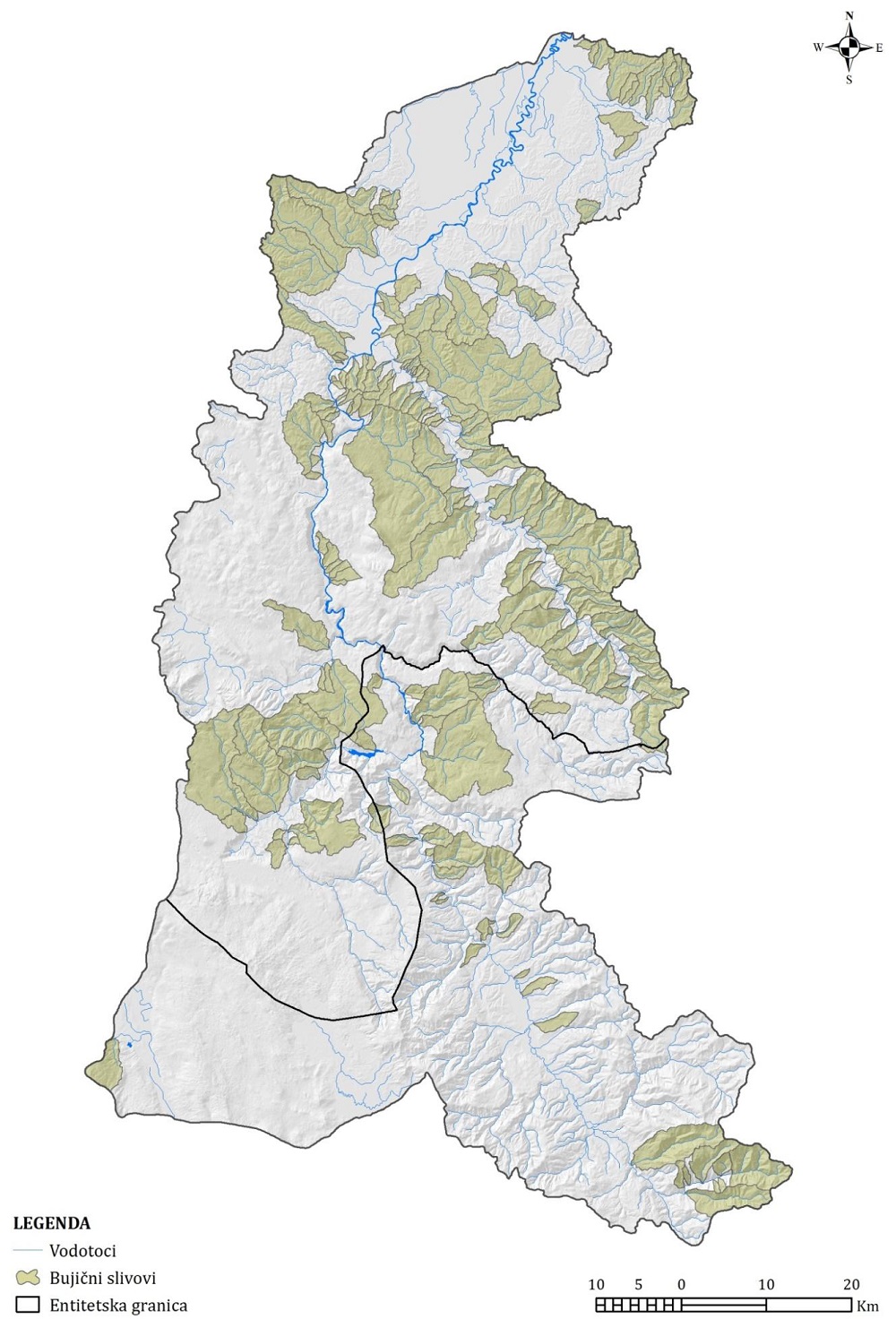
The plan for visiting the basins was defined in the office, including the preparation of topographic maps and their integration into a GIS/GPS device. The indicators of torrential regimes were identified, examined and documented in the field. These indicators, together with the Erosion Map, were the basis for the identification of torrential basins and the development of the Cadastre of Torrential Basins in the Vrbas basin. Torrential watercourses were classified according to the origin of their bedload: underminers, washers, and mixed torrential watercourses. Additionally, they were divided into 6 hydrograph classes (Hk):
Methodological approaches to torrential floods differ across the literature. Today there are a number of widely accepted methodologies that have been very successful in forecasting and preventing the catastrophic effects of torrential floods. In the literature one of the first attempts to evaluate the torrential flood potential of a basin was carried out by Greg Smith (FFPI - Flash Flood Potential Index 2003). In order to improve Smith’s original methodology in terms of more objective results (results do not depend on the subjective attitude of an individual who assigns weight factors), this study proposed adaptation and improvement in terms of creating a new methodological procedure for the development of the Torrential Flood Susceptibility Model (TFSM) in the Vrbas basin. It includes several stages: development of an Erosion Map for the Vrbas basin; development of a Cadastre of Torrential Basins in the Vrbas Basin; analysis and selection of factors that determine the susceptibility; development of a susceptibility model; calibration and validation of the Torrential Flood Susceptibility Model.
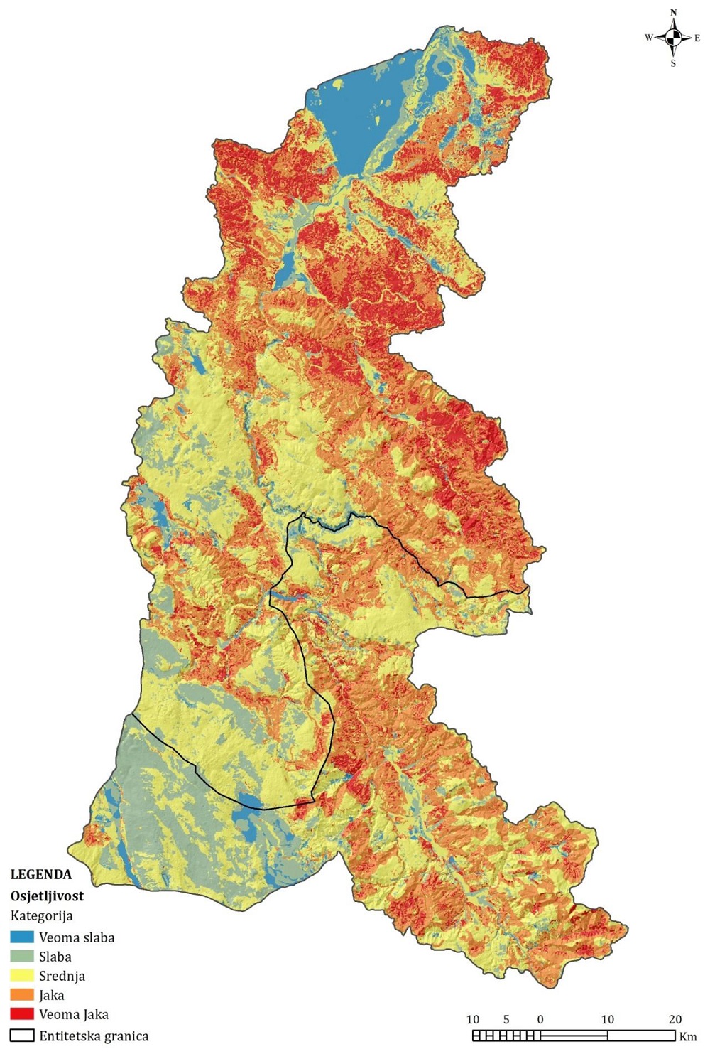
GMM (GIS Matrix Method), which operates entirely in a GIS environment, is based on the analysis of three matrices: torrential basin matrix (TM), total surface of the study area matrix, i.e. the Vrbas basin (TSM) and susceptibility matrix (SM). The use of a classification method in the ArcGIS environment (natural breaks method) will obtain results that can be further reclassified. Based on these, different levels of susceptibility to torrential floods can be shown visually (very low 0 - 1, low 1 - 5, medium 5 - 15, strong 15 - 25, and very strong 25 - 100). This model was validated using a Degree of Fit method.
The erosion map in the scale of 1: 25000 was plotted on a topographic map in the scale of 1: 25000, having a total of 69 topographic sections (TS) and 4524 erosion polygons (plots). According to the data of the coefficients and categories of erosion, the intensity of erosion processes in the Vrbas basin has a moderate character; very poor erosion with mean erosion coefficient (zsr) for the total basin of 0.18, which is V1 category of the strength of erosion processes.

One-hundred and seventy-four (174) torrential basins are identified in the Vrbas basin in this Project. The total surface area of the torrential basins is 1753.33km2. The layout of torrential basins is given in two documents: the Register of Torrential Basins in the Vrbas River Basin and the Cadastre of Torrential Basins in the Vrbas, with quantitative and qualitative indicators of torrential basins.
According to the Torrential Flood Susceptibility Model for the Vrbas basin, 44.14% of the basin is within strong and very strong susceptibility category. If we look at the spatial distribution of these categories, we see that it corresponds to the basins in which it is realistic to expect the appearance of torrential floods considering the intensity of erosion processes, specific runoff and other relevant factors.