


Flood Risk Management Plan for the Vrbas River Basin in the Republika Srpska
Investor: UNDP – B&H
Project developers: Consortium of the Institute for Water Management Bijeljina & Institute for Hydraulic and
Environmental Engineering of the Belgrade Civil Engineering Faculty
Implementation year: 2018-2019
After the ‘RS Water Management Strategy’, this project is one of the most important documents of the water sector. It is a milestone in planning and operational water management in the RS. There are several reasons for such an assessment of the significance of this project, of which the most important are: § This project represents the most effective implementation of the Directive 2000/60/EU of the European Parliament on the assessment and management of flood risks. This project also creates a methodological template how to apply this Directive in other basins, following the elementary objectives of the Directive: analyse flood risks, develop flood hazard and flood risk maps, and flood risk management plans; this will allow timely undertaking of all necessary planning measures in order to mitigate potential flood damage; this must be carried out across entire basin, which is the basic planning unit in water management; § The development of this project and its implementation started a very important phase of cybernetic control of water management systems in the RS. This is a very radical methodological and developmental change, which shifts from the current management, based on experience, to modern management, based on simulation and optimization mathematical models;
- The work carried out within this project made a great progress in processing hydrological data and their organisation in computer systems, which other river basins should follow. The aim of these analyses and IT processing is to allow these data to be used for various purposes, of which the most important are: (a) the production of flood hazard and flood risk maps; (b) the production of flood risk management plans; (c) operational use during flood defence periods; (d) a very important database in all subsequent upgrades of mathematical models into higher control models (forecast real-time control models based on estimation of hydrological inputs) and also for the highest level of control using expert systems;
- A mathematical simulation model of reservoir management was developed, which is successfully applicable for verifying all management decisions during flood waves. These start from the forecast of the flood and arrival of a precipitation cyclone (which is increasingly accurately predicted in Europe and B&H), continue through the reservoir management during the passage of a flood wave, and finish by the end of the flood wave and the transition back to normal operation. This mathematical model was tested in detail on the Bocac reservoir and proved to be extremely functional. Within a few seconds the model shows what will happen for any operation with the gates, so it can be applied for real-time management.
The planning document resulted from this project contains all areas that are relevant for long-term planning and operational decision-making in flood risk management in the Vrbas River Basin in the RS. However, the significance of the document is much broader, because it is a general methodological pattern which can be used in future, given that such plans should be developed in other basins.
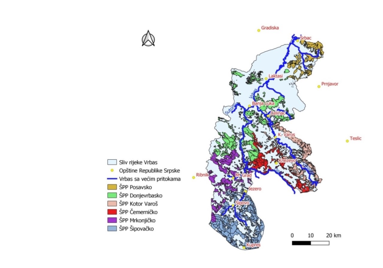
The documents ‘The RS Preliminary Flood Risk Assessment’ and ‘Flood Hazard and Risk Maps for the Vrbas River Basin in BiH’ defined the causes, extents, and other hydraulic and technical parameters of flooding by the Vrbas in the RS.
According to the confirmed Methodology, the risk of floods is determined and categorized by intensity in the floodplain of the Vrbas with its main tributaries in the RS. Spatial definition of flood risks by flood hazard and risk maps (additional maps and data developed in that project, e.g. Register of Torrential Rivers and Basins, and the Torrential Flood Susceptibility Model) together with the existing data (e.g. Erosion Map, Integrated Management Strategy, irrigation, studies, etc.), allow for planned and targeted action in the entire Vrbas basin in the RS, in order to reduce the risk of floods through structural and non-structural measures.
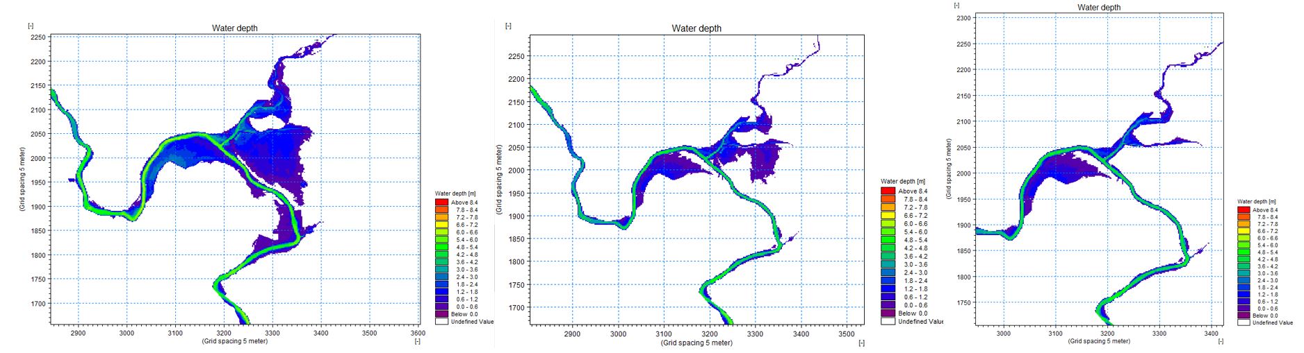
Quality and reliability of the Flood Hazard and Risk Maps in the Vrbas basin (Figure 1) is assured through the following:
- Development of a hydrological model for the entire Vrbas basin in the RS, including consolidation and analysis of all existing meteorological, hydrological and other maps/data. The model was developed and verified. If upgraded and modified, it can be used for the development of a real-time flood forecast model and early warning system, and also to consider the effects of implemented structural measures.
- Development of a continuous hydraulic model for the entire course of the Vrbas and its main tributaries in the RS using unsteady flow. This enabled a more detailed interpretation and understanding of the process and nature of floods in the basin by analysing flood waves routing. It was developed as a coupled 1D/2D model to determine as closely as possible the real flood hazard at any point of the floodplain (result of depth and vector value of flow velocity in each DTM cell). Both hydrological and hydraulic models are developed to allow simple modifications and additions.
- Extensive socio-economic research in the floodplain of the Vrbas and its tributaries, in order to determine the risk of floods for population and economy. This was a high-quality baseline for defining potential flood damage.
(illustrated for the Republika Srpska)
Along with these maps and data developed during the project of mapping flood hazards and risks in the Vrbas basin (the UNDP project in 2017), we also considered previous key documents and maps/data necessary for the implementation of non-structural measures for sustainable management of agricultural and forest land in the Vrbas basin in the RS:
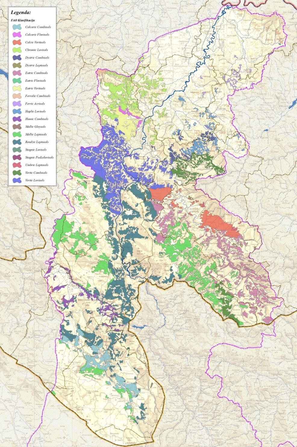
- Soil map of the Vrbas basin in the RS (developed between 2000 and 2002 through the FAO project ‘Inventory of Post-War Situation of Land Resources in B&H’;
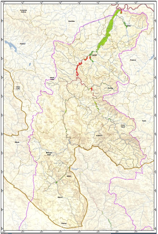
- Erosion Map of the Vrbas basin in the RS (developed by the Water Directorate - PI ‘Vode Srpske’ between 2006 and 2014; updated through the UNDP project of flood hazard and risk maps for the Vrbas basin in 2017, to include erosion processes resulted from the 2014 flood in City of Banja Luka (Figure 2);
- Register of torrential rivers and basins in the Vrbas basin in the RS (developed through the UNDP project of Flood Hazard and Risk Maps for the Vrbas Basin, 2017, Figure 2);
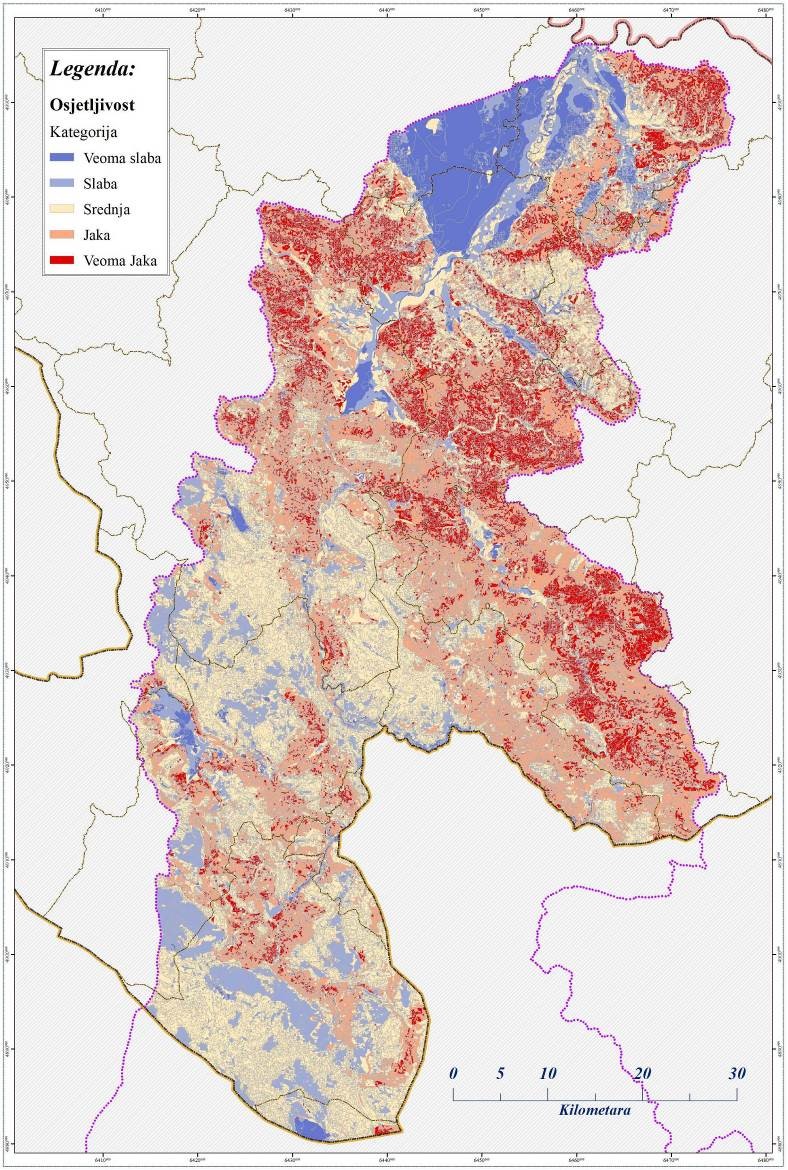
- The Torrential Flood Susceptibility Model (developed through the UNDP project of Flood Hazard and Risk Maps for the Vrbas Basin, 2017, Figure 3);
- Forest management plan and geospatial database on forest land, forest management units, and their plans.
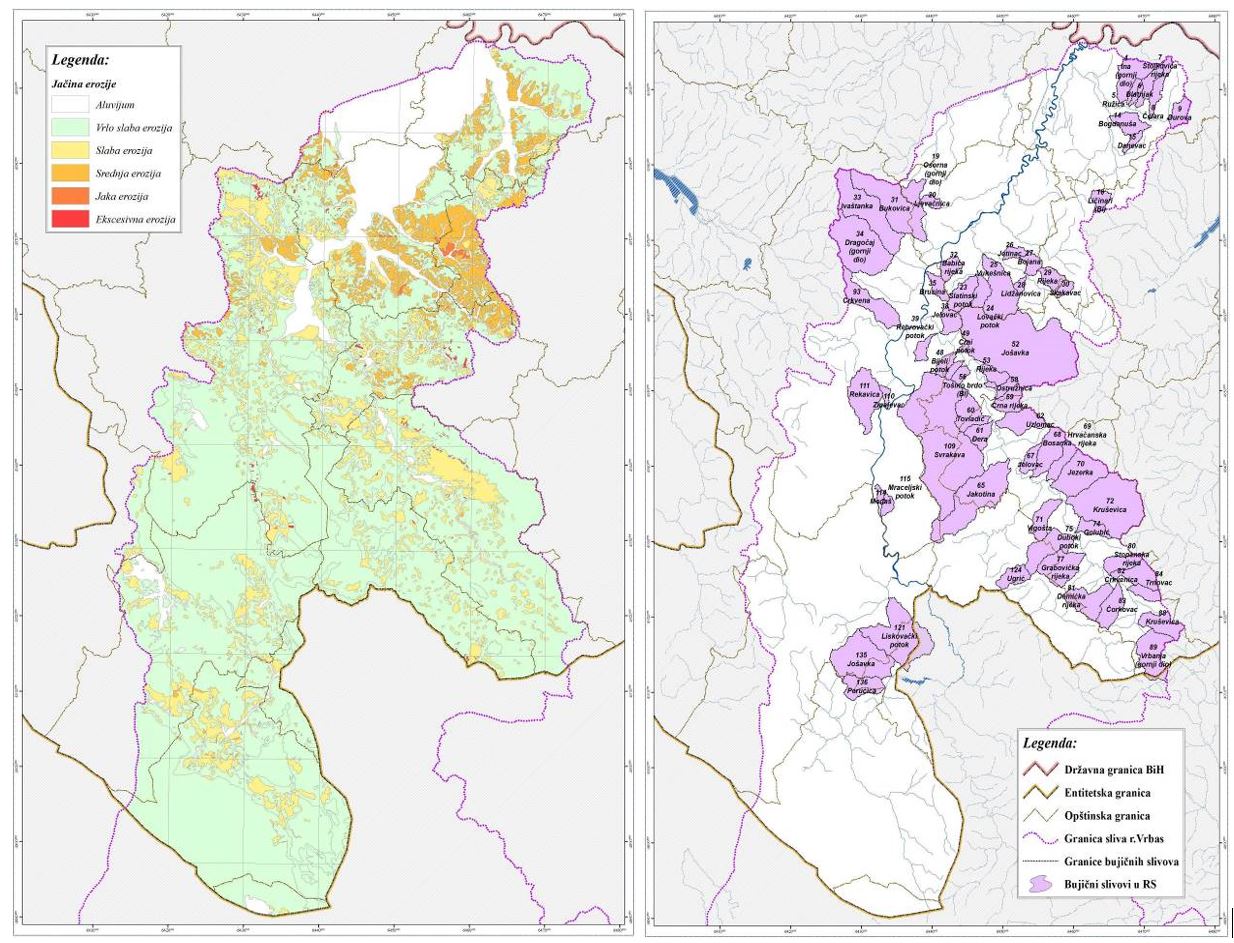
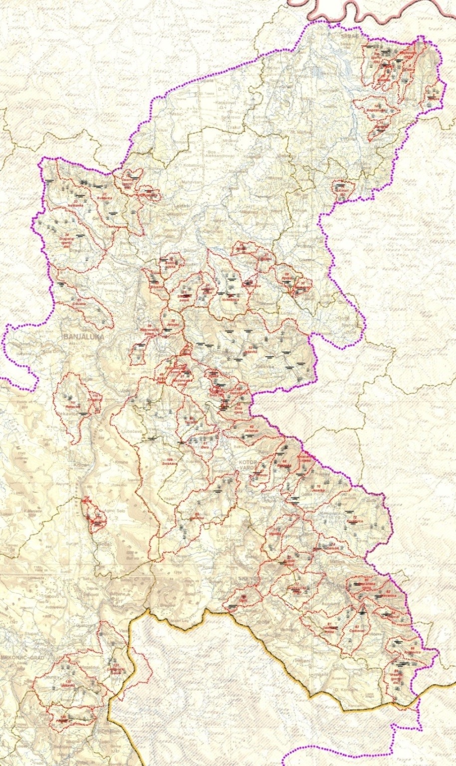
Torrential streams in the Vrbas basin in the RS are unevenly distributed, but it is possible to identify several locations with a large number of them. A previous research in the Vrbas basin in the RS identified 137 torrential basins. Their geospatial representation is given through the Register of Torrential Basins.
The plan addresses all problems of flood risk management, which, for the clarity and easier use of individual users, are divided into special volumes/annexes. The Summary Report provides important summaries for the highest levels of decision-making in the Republika Srpska and the entire water sector. Below is a concise overview of the issues discussed in separate annexes.
Annex 1 clearly consolidates the legal, legislative and normative framework for the development of the Plan. This annex considers all relevant legal documents and documents confirmed as decrees, as well as international documents in force, which are obligatory to be taken into account when making all management decisions in flood risk management. Chapter 3 of the Summary Report provides a summary of the most important legal documents, frameworks and procedures, consolidated in a clear and transparent way for all entities to which these provisions apply.
Annex 2 is extremely important. It refers to hydrological and hydraulic analyses and databases that are important for the analysis of flood risks in floodplains. This annex discusses the advanced electronic consolidation of meteorological and hydrological data for wider usability. These data are important for all further phases of development of management models in the water sector (Figure 4).
Analyses of precipitation, probabilities of flood flows, as well as regional analysis of flood flows are extremely important. Complete flood waves of various probabilities are determined for use in management. A digital elevation model and mapped land use are also provided, which is extremely important for all subsequent decisions in the process of flood risk management. The section dealing with hydraulic analyses provides a geometric model of the Vrbas and its tributaries, boundary flow conditions, as well as important results of hydraulic calculations of water surface levels along watercourses for floods of different probabilities. The effects of proposed flood protection measures are verified in hydraulic 1D and 2D analysis of the most important floodplains (Figure 5).
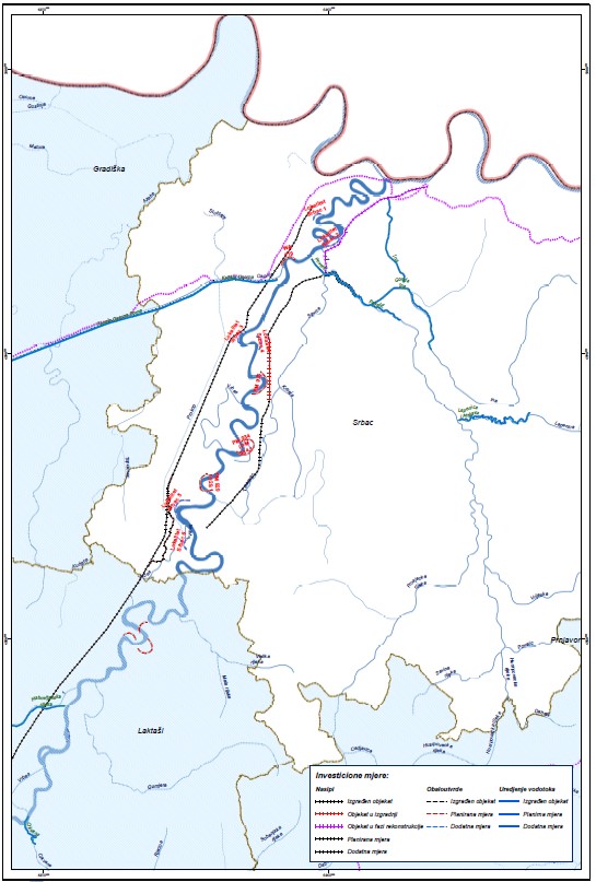
Analyses, databases and digital maps in this annex are valuable data not only for this stage of analysis (flood risk management) but also for all later stages of improving management models, all the way to expert systems, as the highest stage of water resources management.Annex 3 deals with structural protection measures in floodplains in the Vrbas basin. This is extremely important for making specific investment decisions. It discusses the key indicators of flood hazards and risks in the basin, consolidated by municipalities and for the City of Banja Luka. Based on that, the existing structural measures and their effect on reducing the risk of floods are presented. The central part of this annex provides a detailed proposal of flood defence measures by municipalities. The measures are divided into different categories: existing facilities (to be maintained), measures that can be considered on the basis of existing documentation, other structural measures that require developing project designs. In order to carry out an economic analysis, this annex provides an approximate bill of quantities for protection measures and analysis of the effects of these measures, both in terms of risk reduction and the amount of avoided (prevented) damage caused by floods.A very good starting point and numerous projects that were carried out in the past few years (UNDP-B&H, Ministry, PI ‘Vode Srpske’, local communities) provided a solid basis for considering structural measures in floodplains.
Given the large project area, scope of activities and significant pool of information collected in the first months of developing the Plan, structural measures in the Vrbas basin in the RS were analysed using an updated geospatial database (data and maps on flood hazards and risks, hydraulic calculations of the existing situation and after implemented structural measures, existing flood protection facilities, available project and other documentation, elaborated conceptual technical designs considered in this Plan, multi-criteria ranking with priorities, approximate bill of quantities, etc.).
The proposed structural measures included a significantly larger scope of analyses than specified in the Terms of Reference. With a significant effort of project developers, PI ‘Vode Srpske’, and local communities that showed interest in a systematic and integrated analyses of smaller watercourses, the Plan included all previously registered floodplains. Measures are planned at the level of floodplains and by local communities (Figure 6).
Planned structural measures on watercourses of I and II categories, and also on smaller watercourses, will essentially provide targeted engineering responses to flood risk mitigation. In combination with measures for agricultural and forest land management, erosion control works, and active reservoir management, the Plan offers detailed technical designs and strategic guidelines important for the gradual reduction of the risk of floods to an acceptable level in the project area.
The plan classifies structural measures into three categories of priorities, as follows: • Category I – urgent measures; • Category II - short-term measures; • Category III - long-term measures.
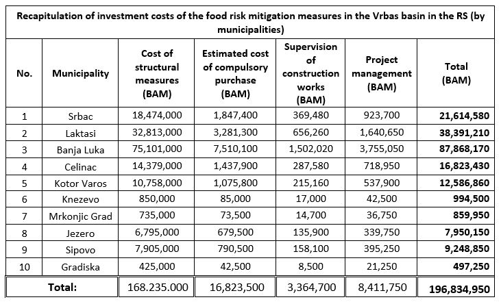
Given the good quality base of detailed designs and a solid technical level of elaboration of preliminary designs, approximate bill of quantities within the Plan specified that about 170×106 BAM is needed for the implementation of structural measures in the Vrbas basin in the RS. Of this estimated investment cost, approximately 2.6% is required for development of project documents, 2% for supervision, 5% for project management, and around 10% for compulsory purchases.
There are 11 planned flood protection structural measures in the Vrbas basin with already developed detailed designs in 5 municipalities. These structural measures will require an investment of approximately 70×106 BAM or 41% of the total estimated investment cost of the flood risk reduction structural measures in the Vrbas basin in the RS.
A multiple-criteria analysis determined a preliminary list of priorities (emergency measures, short-term and long-term measures) for the Vrbas basin in the RS and local communities (municipalities/cities) in the basin. The multiple-criteria analysis included technical, economic, developmental, and social ranking parameters to take into account the needs of smaller, mostly underdeveloped local communities.
The analysis of priorities defined that it is necessary to provide 91.6×10⁶ BAM for the implementation of urgent structural measures for flood protection in the Vrbas basin in the RS. This is approximately 61% of the total required financial investments in reconstruction and upgrade of flood protection system. This data illustrates the current vulnerability of the population and economy based on the flood hazard and risks in the Vrbas basin in the RS.
Short-term flood protection measures, which also need to be implemented in a short period of time, require an estimated investment of 38.6×10⁶ BAM, or 26% of the total estimated cost of structural measures to mitigate flood risk in the Vrbas basin in the RS.
The long-term measures include structural measures which would complete and bring to an acceptable level the flood protection system against the Vrbas and its tributaries. The estimated financial investment for this category of structural measures is 20.1×10⁶ BAM or 13% of the total estimated cost of structural measures for flood risk mitigation in the Vrbas basin in the RS.
Based on the structural measures, we analysed the required investment costs (Table 3) and the priorities for which RS competent institutions must carry out a strategic assessment of the implementation given the investment costs.
Annex 4 includes an analysis of non-structural protection measures. They are extremely important, because their goal is to firstly stop the increase of flood damage by planning measures and improved sustainable management, and then to reduce the flood damage during the implementation of protection systems.Annex 4.1 considers sustainable management of agricultural and forest land. It also proposes erosion control measures for endangered areas in the RS, which would also achieve the flood protection goals in the best economic and developmental way. The section related to agricultural land first disscuses the state of agricultural land in the Vrbas basin, followed by consideration of the most acceptable land use outside floodplains, as well as the measures for its protection.The erosion control works include sustainable management of agricultural land actively for production located on slopes of more than 8%, where it is planned to use a gradual approach (Figure 7).
The section related to forest land discusses the state of forests and forest land within six companies responsible for forest management. This section analyses effective impact of good quality forests on flow regimes, as a way to improve forest management to achieve their most favourable
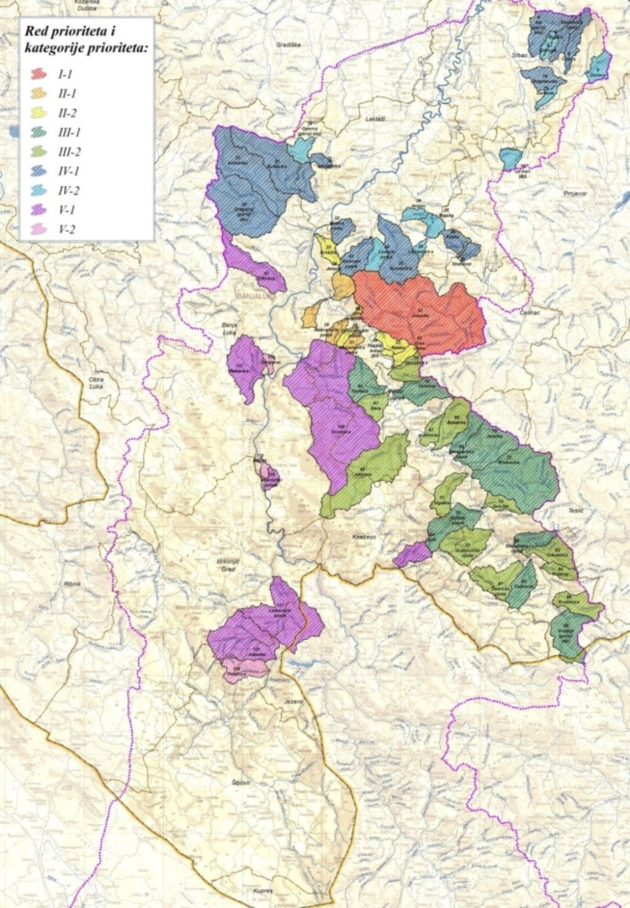
An extremely important third section of Annex 4.1 considers erosion control works as a protection element against adverse effects on floods, especially torrential floods. This analysis shows the usefulness of an earlier decision to produce the RS Erosion Map with its final GIS-based result, and subsequent development of a register of torrential rivers and a torrential flood susceptibility model (through a UNDP project). This created the basis for highly operational planning of erosion control measures.The section dealing with erosion consolidates erosion control measures and priorities (Figures 9 and 10), and phasing of these measures with the legal framework for their implementation. A reliable approximate bill of quantities was made on the basis of preliminary field visits.
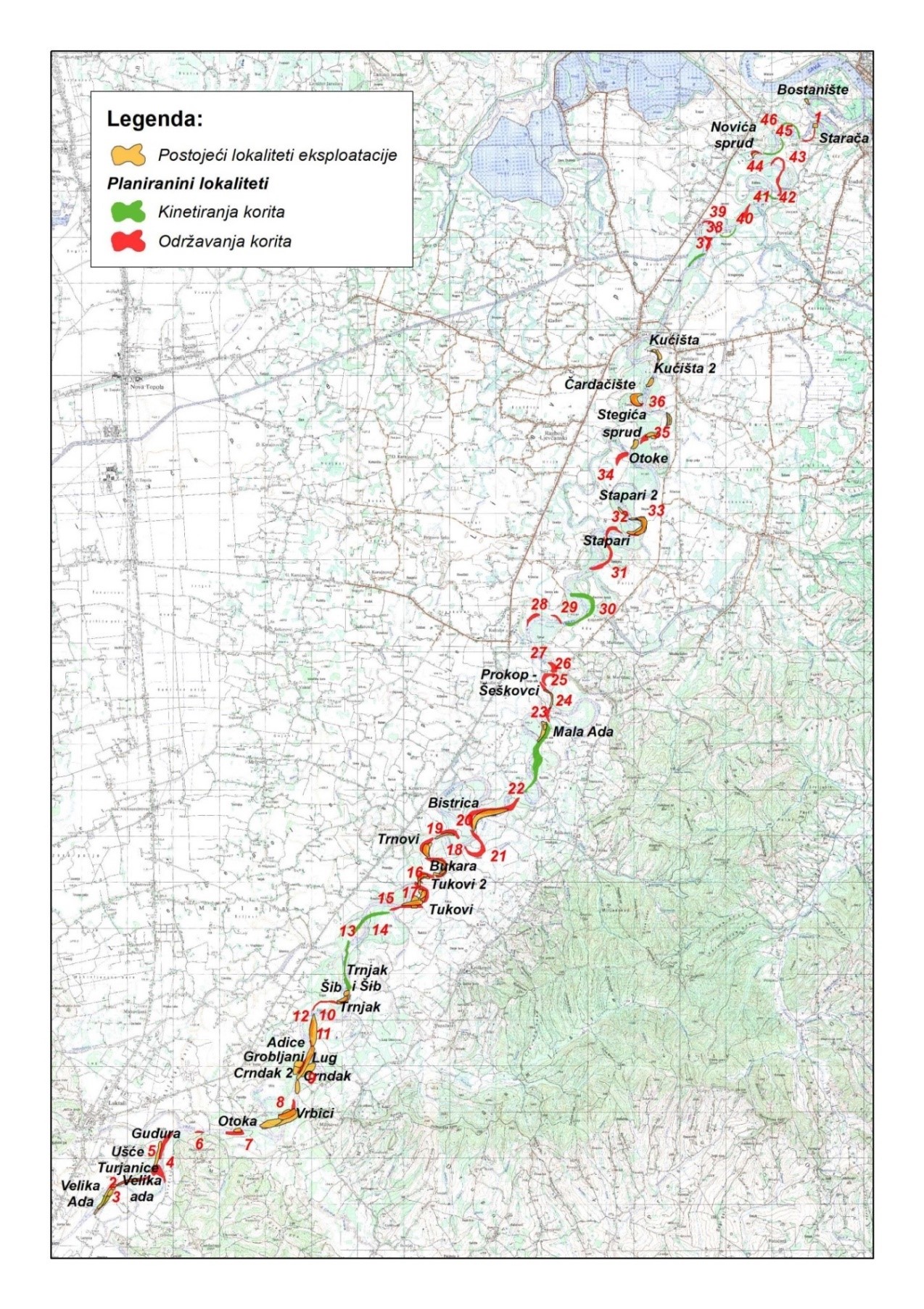
Annex 4.2. considers sustainable management of the sediment regime in the Vrbas basin. It analyses all important phenomena that cause the movement and transport of river sediments in the Vrbas and its tributaries: morphological changes in the lower course of the Vrbas, problems of river channel maintenance, sediment transport balance and impact on the morphology of the river channel. These analyses produced a proposal of a method of sustainable management of in-stream sediment mining, which includes determining the mining locations (Figure 11).
This is an extremely important issue because the current ways of river material extraction are significantly unfavourable from the aspect of environment, water management, and planned development. It is a random and unregulated extraction of river material that is completely unacceptable and environmentally disastrous.
Annex 4.3 is the most important from the aspect of the goals of the Plan, because it deals analytically and precisely with the possibilities of flood defense by applying adequate management of reservoirs. Of the three groups of goals of all man-made systems (survival, growth and development), the absolute priority have survival goals. This is a result of the fact that on the scale of human values, the priority is always the safety of people from natural disasters, primarily from the destructive effects of water that endangers human lives and material goods and values. Therefore, flood defence systems are the most vital and the most sensitive systems that man builds. This is a law that exists from the oldest hydraulic engineering civilizations, which based their development on the construction, good maintenance, and constant improvement of flood defence systems. This is the basic starting point for the analyses carried out in this annex.
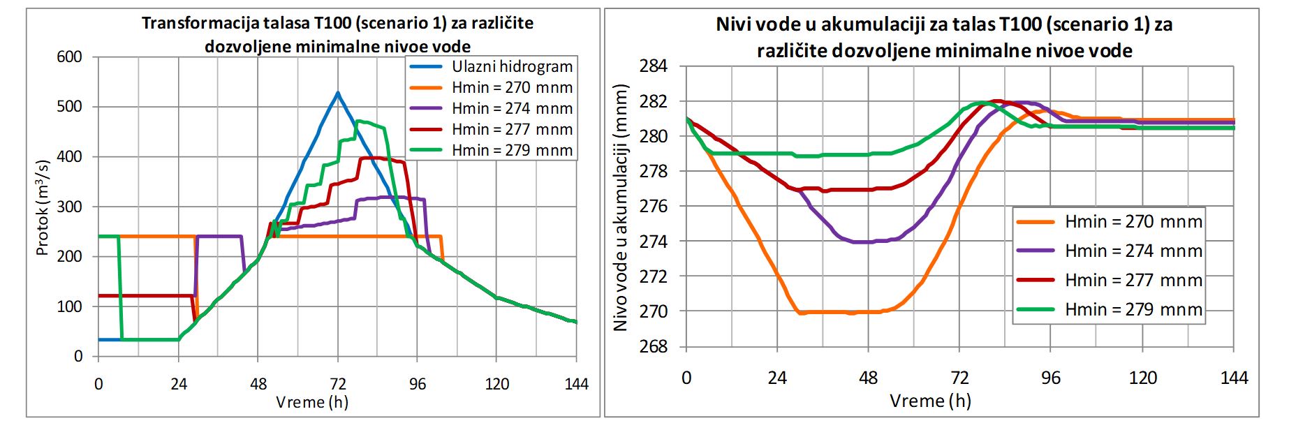
This annex discusses the mathematical model simulating refill and drawdown of the reservoirs and the coordinated work of hydroelectric power station and spillways, in order to best reconcile the interests of energy industry, as the primary user of the Bocac reservoir in normal hydrological conditions, and requirements of active flood defense. Flood defence requirements become a priority as soon as a dangerous precipitation cyclone is forecasted (usually a couple of days in advance) which may cause flood waves. This is extremely important because it was not uncommon in the past to make a management error by maintaining the flood storage space empty at all times in case of a sudden flood wave. This was management nonsense which significantly reduced the operating and production performance of many valuable multipurpose reservoirs, because the upper, most valuable part of the reservoir was constantly kept empty, instead of being used and bringing benefit to energy supply or other development benefit. It is incomparably more reasonable to start using the flood storage space flexibly and for other users. This would allow partial and controlled use of that space when filling the reservoir. The precondition for this is to plan and install strong spillways (gates) and bottom outlets. Given the increasingly successful hydrometeorological forecasts of flood waves, these can be used for timely pre-release of water from the reservoir as soon as an information is received that a precipitation cyclone is approaching which will lead to flood waves.
This appropriate principle was used for designing the layout and management of the Bocac reservoir and hydroelectric power station. Given that hydropower is one of the primary users and due to better production performance of the hydroelectric power station, it was decided to maintain and control the water elevations in the Bocac Lake in the zone used for flood defense. This will achieve better energy effects. As soon as forecast on the onset of the flood wave is received, flood defence becomes a priority and operating regime of the Bocac HPS and the reservoir are switched accordingly. This operating regime switches on both turbine-generator units and spillways to lower the water elevations in the lake to the desired level. This prepares the lake to effectively meet the goals of active flood defence. Modern methods of meteorological observations, with the use of both geostationary satellites and short-term forecasts, allow forecast of large precipitation cyclones about two days in advance. This enables the transition to the active flood defence regime at the Bocac HPS immediately after receiving that information. This is a very sensitive operation in terms of management, because the right measure must be found for the planned lowering of the water elevation in the lake so as not to unnecessarily reduce the production capacity of the Bocac HPS. Lowering the water elevation must be (sub)optimized so that it is only to the levels necessary to achieve the objectives of flood mitigation and active flood defence. The word ‘sub-optimization’ is used because the calculations include a series of mathematical simulations and searching the attenuation results. The most favourable control option is known only after few seconds. This control option is also necessary, in terms of criterion to mitigate the flood wave by using only the necessary lowering of the elevation in the lake, without unnecessary energy losses. The model developed in this Plan enables reliable and planned implementation of this management goal.
The model was tested on a series of flood waves, two scenarios for flood wave formation and two for a series of waves of different probabilities. It was shown that skillful management, with timely pre-release of water from the Bocac reservoir can, in some cases, successfully mitigate the flood wave of 1% probability (one-hundred-year flood flow). Waves of even rarer probabilities (e.g. five-hundred- year flood wave) can be mitigated to a lesser extent. However, it cannot be expected to use a reservoir with a relatively modest storage volume to attenuate cataclysmic flood events.
Active flood defence is becoming especially important in the context of climate change. The most dangerous consequence of global climate change, and also of other anthropogenic impacts in river basins (deforestation and urbanisation, which increases runoff coefficients and accelerates the time of wave concentration), is that flow regimes significantly deteriorate compared to earlier natural conditions. This is not distant future but unfortunately our reality which must be reckoned with. Flood waves have shorter and shorter concentration times, while wave peaks are getting bigger. In such circumstances reservoirs of larger storage equipped with fully automated spillway gates become very important. The Bocac dam is equipped with such spillways. It is a well-installed hydroelectric power station with a dam toe powerhouse and a reservoir which, with adequate management by using mathematical models, can act in active flood defence in a number of unfavourable hydrological situations.
This annex has methodologically successfully solved all these problems, analytically proving that the role of the Bocac reservoir is very important for active flood defense. However, the annex discusses the possibilities of other planned reservoirs within the integrated water management systems in the Vrbas basin. Undoubted priorities were identified. It turned out that the Vrbanja basin, due to its characteristics and position in the hydrographic system (practically in the City of Banja Luka), represents a great danger for the city and areas in the downstream course of the Vrbas. Analyses show that the problem of flood protection of the Vrbanja cannot be solved if some of the planned reservoirs are not constructed. This would enable active flood defence by mitigating a very large flood wave which is quickly formed and concentrated in the Vrbanja basin. Analyses show that in that respect, the Celinac reservoir is very important and necessary, even with a slightly smaller storage capacity compared to the previously planned one. The lower part of the Vrbanja valley and the City of Banja Luka cannot be reliably protected without this reservoir.Annex 4.4 considers other non-structural measures that have a positive effect on curbing the increase in flood damage and their subsequent reduction. This primarily refers to spatial planning which allows area to be as resilient as possible to critical flood situations. These are very important planning activities, such as: transparent positioning of new integrated systems to reserve these locations for that purpose; protection and preservation of public water resources; maintaining floodplains free from flood-sensitive contents; regulations for managing floodplains; prescribing construction conditions to minimize flood damage; establishing a more reliable real-time flood forecasting system; preparing land to reduce potential damage in floodplains; etc. These are the least costly measures that largely contribute to damage reduction in accordance with the currently accurate motto: 'Prepare the land to be able to live with floods'. Therefore, this annex is extremely significant because a small investment cost will achieve large savings by limiting and reducing potential damages. Annex 5 deals with the financial and economic analysis of the planned works to determine key indicators of economic profitability of investments in protection measures. The usual Cost Benifit Analysis (CBA) was adjusted to the current issue. Economic damages from the averted floods were considered as benifits. Special emphasis was placed on urgent structural measures divided into two six-year stages. Given the importance of investment priorities, a multiple-criteria decision anlaysis was carried out to rank urgent structural measures, and, at the same time, to define the timeline of the proposed measures. Analysis was based on five key criteria for ranking priorities: flood risk mitigation effect; investment value of regulation works; achieved stimulating socio-economic effect in local communities; creation of conditions for development of urban and other contents in protected areas; effect/impact of regulation works on the environment. Annex 6 analyses the impacts of planned flood protection measures and facilities on the possibilities of integration into the environment and environmental protection. The analysis used all relevant components of possible impacts: starting with the methodology for assessing the status of surface and groundwater bodies and the assessment of that status of the watercourses in the Vrbas basin, followed by the impact on sources, sewage systems and wastewater treatment conditions, agricultural land and land reclamation systems, the problems of river banks planning, sediment regime, ichthyofauna, and finishing with a proposal of concrete measures by which the negative effects can be either completely removed or reduced to an acceptable level. Annex 7 deals with the IT aspects of the Plan. As this is a decisive development step in switching to the cybernetic control of water management systems, databases were adapted to this fact and they use a modern GIS technology. This technology is suitable for all types of planning and also for future upgrade of mathematical models, including expert systems as the most modern support for system management, especially in emergency situations, when the ability of perception and quick decision-making of people is reduced because of stress. This part of the Plan starts from reality, i.e. the analysis of the current state of information systems in the RS and then shows how to choose a software for GIS databases. It consolidates key databases, and finally shows how to use databases organized in such way when using the Plan.