


Update and Innovation of the Republika Srpska’s Erosion Map
(PI 'Vode Srpske', 2006 – 2015)
A large portion of land in the Republika Srpska is affected by erosion processes of varying intensity. Prerequisites for the development of erosion are geological and geomorphological specificities, hydrological, pedological and climatological characteristics, the state of the woodland, and different ways of land use.
This project began with activities on collecting relevant data on the Erosion Map of SR Bosnia and Herzegovina, and the development of the Programme for Revitalization of the RS Erosion Map by the Institute of Water Management from Bijeljina.
The subject of research of this Project is the current state of erosion processes, i.e. the extent and intensity of water erosion in the river basins in the RS. Research of water erosion intensity, preparation of the RS Erosion Map by the empirical method of S. Gavrilovic and R. Lazarevic, and its comparison with the results of the B&H Erosion Map, provided an insight into the current state of this process in the RS river basins. Therefore, the main goal was to determine and objectively assess the current state and spatial distribution of erosion categories (intensity of erosion processes) in the river basins and municipalities. This created a basis for qualitative and quantitative description erosion, i.e. production and transport of sediments in the basins in the RS. The RS Erosion Map prepared in this way is a thematic map necessary for the analysis of the spatial distribution of erosion processes, the establishment of sediment production, the establishment of the average annual total sediment yield fluxed from the river basin into the main recipient. It is also a basis for analysing sediment accumulation in river channels, reservoirs, and peripheral canals, as well as the basis for considering the vulnerability of water management facilities to sedimentation.
The work on studying the intensity of water erosion at the experimental stations carried out by the Institute of Forestry and Wood Industry from Belgrade, especially in Bosnia and Herzegovina (Snagovo-Zvornik and Radobolja-Mostar), enabled R. Lazarevic to see certain shortcomings of the Gavrilovic method. Determination of the erosion coefficient (Z) using the Gavrilovic’s tables for parameters (X·a), (Y) and (Φ) and following analytical procedure showed that the resulting values of the erosion coefficient (Z) did not correspond to those measured at the experimental stations. R. Lazarevic (1969, 1971, 1985) modified the Gavrilovic’s Erosion Potential Method (EPM) by changing the values of the X, Y and Φ parameters. That is, he defined new tables with new values for the X, Y and Φ parameters necessary for the calculation of the erosion coefficient (Z). Thus, the methodology of S. Gavrilovic (EPM) was modified/corrected by R. Lazarevic.
- Lazarevic (1983, 1985) developed a new procedure (Lazarevic’s Synthetic Method) for determining the erosion coefficient (Z) according to the Erosion Potential Method (EPM). Mapping erosion intensity according to the Erosion Potential Method (EPM) / Lazarevic Synthetic Method (1971, 1974, 1985), is based on determining basic parameters on which the erosion process depends, as well as their quantification, in order to calculate the intensity of water erosion. The Lazarevic’s new synthetic method is based on the coefficient of erosion type (Φ), which is determined directly on site, as a common factor of all parameters included in the formula for the calculation of the erosion coefficient (Z) and the mean slope (Isr), which is the most objective parameter of this formula. Therefore, the coefficient of erosion type (Φ), the essence of which is the land use (coefficient of soil protection against erosion X) dependant on slope (Isr), gives the erosion coefficient (Z). This methodology was used in the development of the Erosion Map of Bosnia and Herzegovina (1985), as well as in the update and innovation of the Erosion Map of the Republika Srpska.
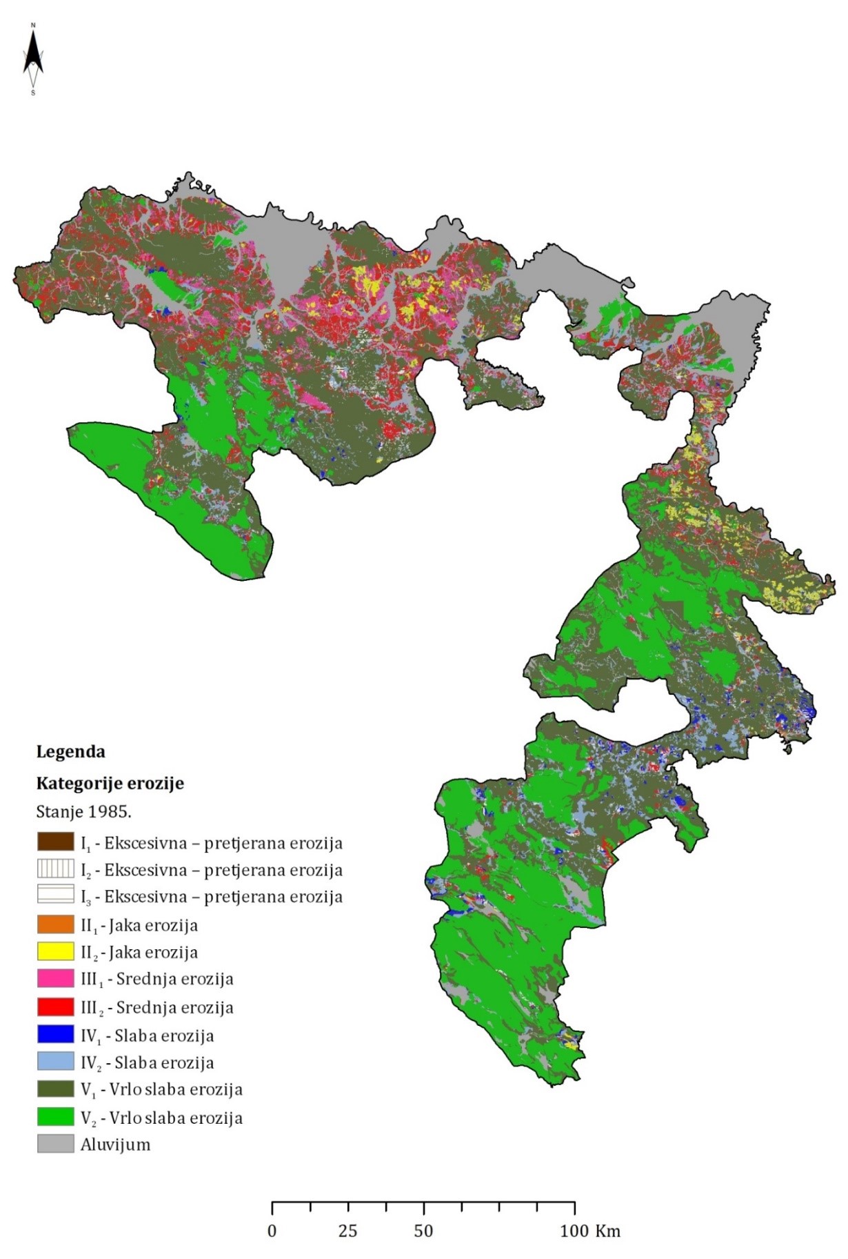
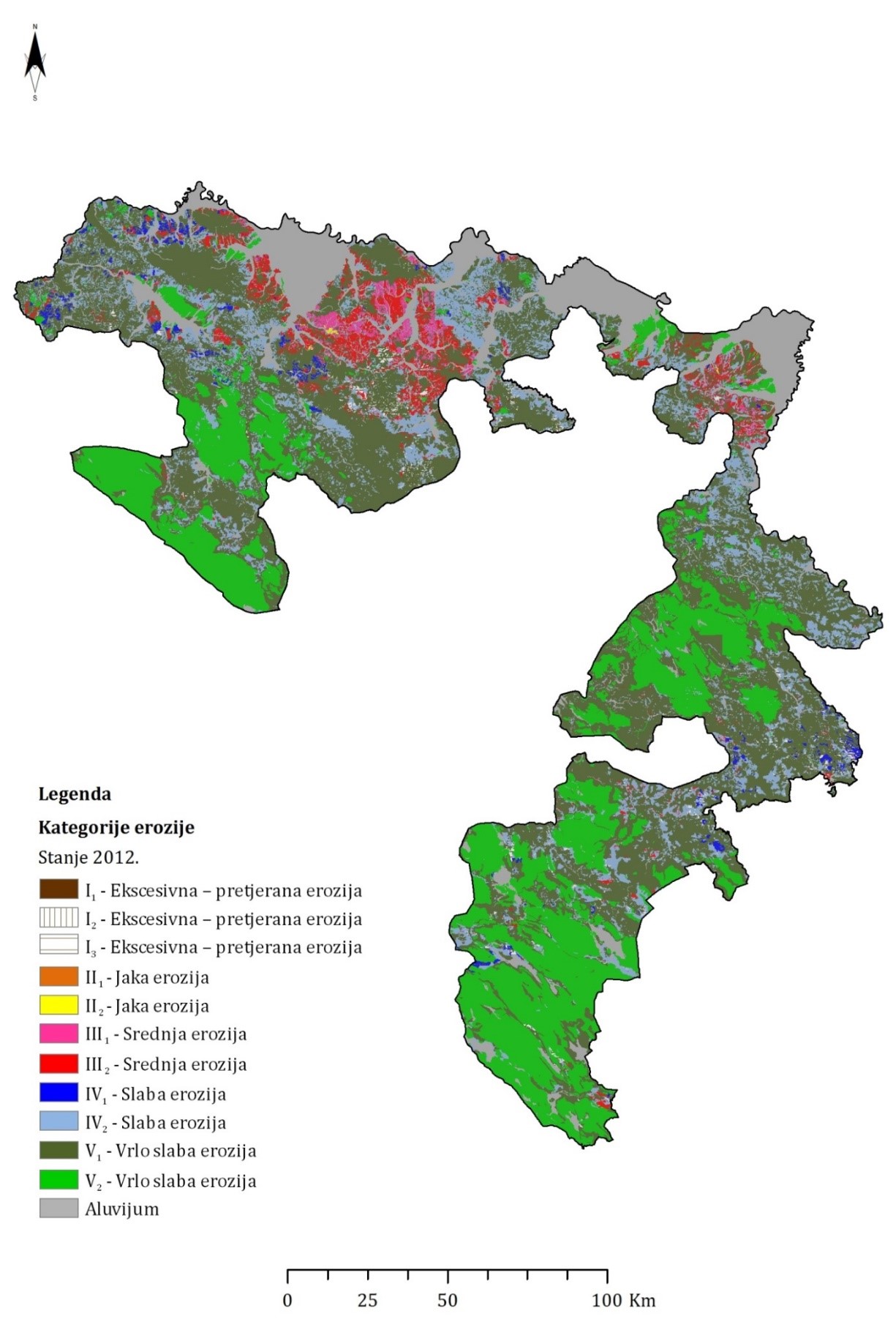
According to the Lazarevic’s synthetic method (1985), erosion map includes 11 erosion intensities divided into five categories and one category of sediment aggradation. The erosion categories are: excessive, strong, moderate, low and extremely low erosion (with sub-categories).
The Lazarevic’s synthetic method was used for the mapping of the intensity of water erosion and development of erosion map, while the Gavrilovic empirical model was used to calculate the mean annual sediment production in a basin (W) and the average annual total sediment yield (G) which fluxed from the basin into the recipient.
Within this project, the Erosion Map of SR Bosnia and Herzegovina was updated (reconstructed) but only for the territory of the Republika Srpska. On the basis of updated data and maps, we identified quantitative indicators of the intensity of erosion processes in basins partially or entirely located in the RS.
According to the SRB&H Erosion Map from 1985, which was upsdated within this project, of the total area of the RS, 21,851.04km2 or 86.96 % is affected by erision, while 3,277.18km2 or 13.04% is affected by sediment accumulation. The SR B&H Erosion Map, updated for the RS, reflected the state of erosion (1985) in the 1980s, as well as the then distribution of individual intensities of erosion. The total sediment production according to the 1985 RS Erosion Map amounted to 6,516,230.80m3/per annum, or 298.21m3/km2/per annum. According to the 1985 RS Erosion Map 2,912,670.58m3/per annum of sediment was permanently lost from the RS, or 133.30m3/km2/per annum.
According to the updated RS Erosion Map, in 2012, 86.95% of the territory was affected by erosion processes, while the sediment accumulation was dominant on 13.05% of the territory. According to the categories of intensity of erosion processes, 0.87% of the territory was affected by excessive erosion, 0.03% by intensive or strong erosion, 5.22% by moderate erosion, 17.08% by low erosion, and 76.77% by extremely low erosion. The total sediment production was 5,242,343.79m3/per annum or 239.91m3/km2/per annum. 2,350,317.19m3/per annum of sediments is permanently lost from the RS, or 107.56m3/km2/per annum.
Erosion is an example of a natural process that is strongly associated with human activity, primarily through land use but also through other anthropogenic activities. Numerous trends of socio-economic processes in the Republika Srpska caused changes in land use, which has been reflected in the intensity of erosion. Socio-economic processes from the period 1992-1995, and even after that, determined a completely new character of the spatial distribution of the intensity of erosion, defining a new picture of the state of erosion and the spatial distribution of different categories of erosion intensity. The analysis of the erosion intensity trend in this area for the last thirty years clearly concluded that the intensity of water erosion in the Republika Srpska has a dominant anthropogenic character, i.e. that the impact of human activity is almost the most important cause to development and intensification of erosion and accumulation processes.