


Preliminary and Detailed Designs
Improvement of the Left Drina Bank Between the Confluence of the Krizevica and the Confluence of the Glogovska River Including the Construction of Flood Defence Embankment
(Institute for Water Management, Bijeljina & CHT Hidropoint, Banja Luka & HEC, Banja Luka, 2020)
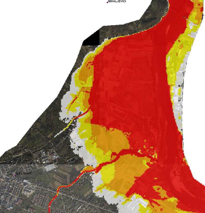
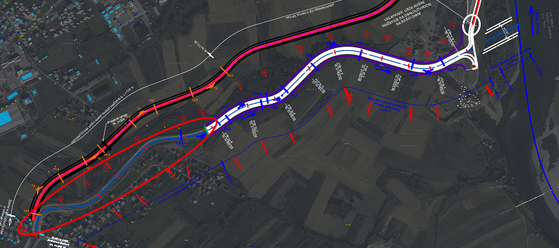
The hazard and risk of flooding by the Drina, Krizevica and Glogovska rivers in the project area in the municipality of Bratunac was assessed as high and extremely high according to the Flood Hazard Maps and hydraulic analyses (Figure 1).
The municipality of Bratunac has potential for further urban expansion and increase of economic and urban activity in the mapped flood area, especially after the completion of the new bridge and border crossing with the Republic of Serbia (the Bratoljub Bridge). Therefore, it is necessary to launch targeted and extremely challenging measures to reduce the risk of floods and implement measures to control flood flows. This will allow planned expansion of urban and economic areas and also protect population and their material goods from floods both in existing urban and the planned areas.
Respecting the general observations and guidelines from the flood map project in B&H, and on the basis of the Terms of Reference, we developed the Preliminary Design and subsequently the Detailed Design of the flow regime control and improvement of the river channels of the Drina, Krizevica and Glogovska rivers. This design defined the basic technical parameters of the following:
-
-
- Construction of the left Drina embankment in the area of dominant flood flow breach;
- Improvement of the main channel of the Glogovska River and construction of flood defence structures along the channel in the section of dominant flood flows;
- Improvement of the main channel of the Krizevica River and construction of flood embankment along the channel in the section of dominant flood flows;
- Internal drainage within the future ‘Bratunac’ protected area;
- Stabilization of the left Drina bank between the confluence of the Krizevica and the confluence of the Glogovska River.
-
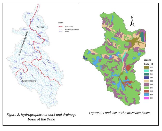
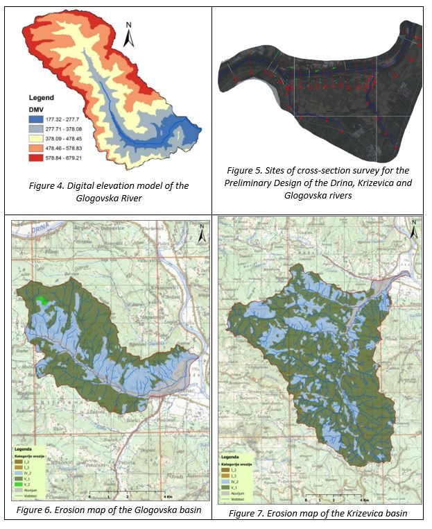
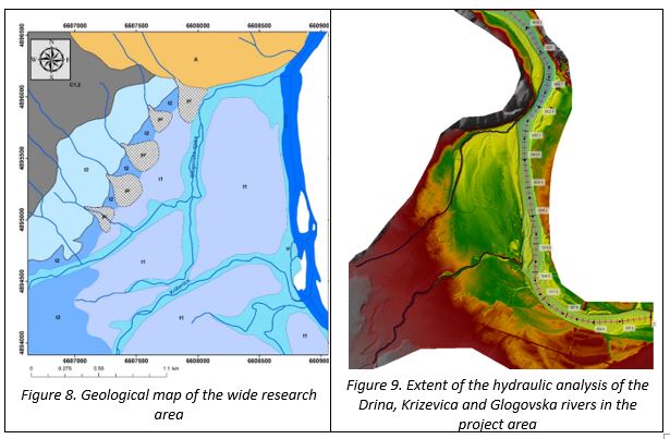
All technical parameters were determined on the basis of previous hydrological, geodetic, geological-geotechnical, erosion, sediment and other surveys (Figures 2-9):
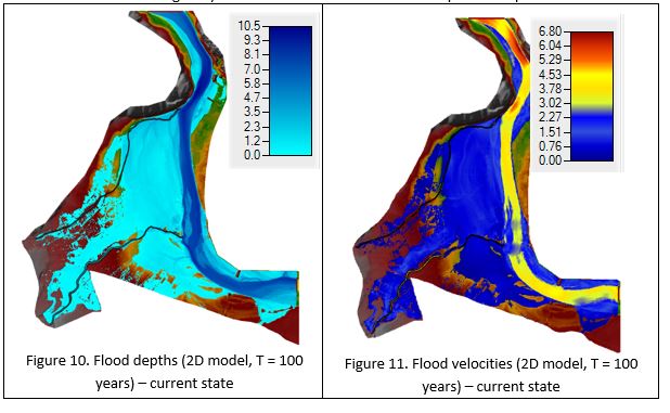
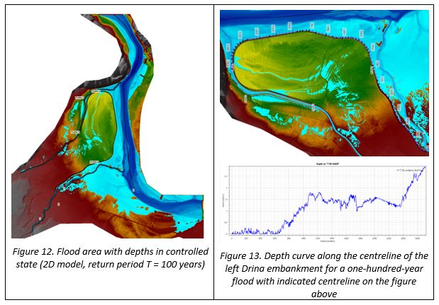
The Preliminary Design provides an integrated technical solution for the flow regime control of the Drina, Krizevica and Glogovska rivers downstream from the intersection with the Skelani-Bratunac-Zvornik regional road. It also provides systematic measures for flood protection, reconstruction and rehabilitation measures for flood protection facilities, planning measures and guidelines aimed at increasing the effectiveness of flood protection in wide urban area of the municipality of Bratunac. All of these solutions and measures are informed on previous hydraulic simulations and analysis of 2D models of unsteady flow in the project area, Figures 10-11 (the current state), and Figures 12-13 (the state of controlled flow regimes) in the area of the future ‘Bratunac’ protected polder.
The Preliminary Design elaborates technical solution and a concept of protection against flooding of the Drina, Krizevica and Glogovska rivers:
-
-
- Level of protection: In order to control flow regimes of the Drina, Krizevica and Glogovska rivers, detailed design elaborated a construction of an embankment which will provide protection against a one-hundred-year flood with 80cm freeboard above this design flood (in regulated state of the main river channels). This freeboard does not allow passage of a five-hundred-year flood. However, the level of protection can be increased by implementing measures to regulate the Krizevica and Glogovska river basins by reducing direct runoff from the basin and peak flood waves.
- The necessity of carrying out river channel improvement measures on the Krizevica and Glogovska rivers is especially emphasized, because the existing regulated river channels upstream from the regional roads between Skelane and Zvornik are not able to pass the designed flow rate. Therefore, despite all flood control measures, water might spill over the river bank and overflow the roads into the protected area. The embankments along the Glogovska River are mainly designed along the main river channel due to the urbanization of the banks. The situation on the Krizevica and Drina rivers is more favourable in terms of positioning embankments at a safe and sufficient distance from the main river channels. This will maximize the floodplain area, resulting in almost identical flood levels before and after carrying out the flow regime control measures. This is especially important, because the designed embankments do not raise the level of flood flows of the Drina and thus increase the flood hazard and risk on the right bank in Stara Ljubovija in the Republic of Serbia.
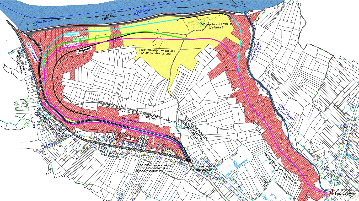
- The route of the left Drina embankment
-
The basic factors for selecting optimum embankment route are:
-
-
- Geologically and geomechanically stable ground;
- The impact of the embankment construction on raising the flood flow levels, especially on the right bank of the Drina River in the Republic of Serbia;
- Ownership of the land where the embankment will be constructed;
- The surface area of land which will be protected from flooding in future, as well as the surface area of land that will remain in undefended section;
- The length and the height of the embankment;
- All options of the embankment route end at high elevations at the intersection of the river Krizevica with the Bratunac-Skelani regional road and of the Glogovska River with the Bratunac-Zvornik regional road.
-
Option 3 was selected as optimum after detailed analysis of criteria (Figures 14-15).
-
-
- The route of the regulated channel section of the rivers Krizevica and Glogovska
-
The Krizevica River:
Possibilities of different options for the route of the regulated main river channel of the Krizevica are limited along the entire length of the project area by:
-
-
- The existing end of the regulated channel of the Krizevica 615m downstream from the intersection with the Bratunac-Skelani regional road;
- The designed route of the left Drina embankment in the area affected by the backwater of the Drina, and the left Krizevica embankment in the area of design flood flows of the Krizevica;
- The river engineering works around the confluence of the Krizevica and the Drina, and the canal cutting across the river island to allow a corridor for the intersbasin transfer of water from the Krizevica to the Drina;
- Design of minimum radii of curvatures that meet the hydraulic parameters of the river regulation.
-
The river training works include a 857m section of the main river channel from the end of the existing regulated section downstream to the confluence with the Drina. The radii of curvature are between 100 and 220m. At the downstream end of the regulated channel section, it is planned to line the streambed and channel slopes around the confluence of the Krizevica and the Drina, as well as to level off the bar in the Drina (along approximately 100m with 40m width at the bottom), which prevents the interbasin transfer of water (Figure 16).
The Glogovska River:
The river training works of the Glogovska River will follow the existing river channel as much as possible to minimize permanent earthworks and optimize land compulsory purchase required for a corridor mainly located within the public water body. Given that the corridor for the construction works is bordered by the designed left Drina embankment on the right and the Bratunac-Zvorink regional road on the left, possibilities of the route of the regulated river channel along the entire project area are limited to only one option.
-
-
- The regulated section of the main river channel will start at the downstream end of the existing regulated section (chainage 1+166.00) and end at the confluence of the Glogovska River and the Drina (chainage 0+000.00);
- Upstream from the chainage 1+166.00, it is planned to reconstruct and extend embankments and flood defence walls up to the intersection of the Glogovska River with the Bratunac-Zvornik regional road;
- The total length of the river training works, including the existing regulated section, is 1,657m. The radii of curvature will be between 80 and 480m. It is planned to line the streambed and channel slopes around the confluence of the Glogovska and the Drina rivers at the downstream end of the regulated section (Figure 17).
-
-
-
- Cross-sections
-
The Drina embankment
The embankment on the left Drina bank (2.13km long) has trapezoidal cross-section and is 5m wide at the crest (Figure 18).
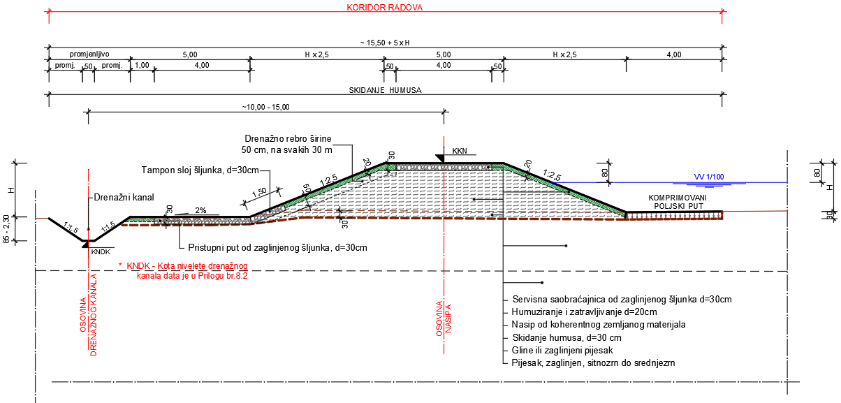
The slopes on both landward and riverward sides are 1:2.5. A 4m wide clay gravel service road is designed along the crest of the embankment (30cm thick road surface). The embankment slopes and a part of the crest (2 x 50cm) are covered with topsoil. The embankment crest is designed with 80cm freeboard above the level of a one-hundred-year flood in regulated state.
On the landward slope of the embankment, it is planned to lay a 30cm gravel base along 1.5m from the bottom of the slope, which is in direct contact with the service gravel road on the landward side. Horizontal drains along the embankment slope are designed from the crest to the service road on the landward side. Horizontal drains and a gravel base on the landward slope of the embankment will allow drainage of rain water from the embankment crest. After filling drainage hole with gravel, the embankment slopes will be covered with topsoil and grass which was previously removed.
Along the edge of the embankment slope on the landward side, there will be an access road to the plots, which will also be used as a service road for the maintenance of the embankment. The clay gravel road will be 4m wide and the thickness of the road surface will be 30 cm. A drainage ditch is designed along this access road on the landward side. The ditch will have a trapezoidal cross-section, 50cm width at the bottom, with 1:1 slopes. The ditch will drain surface water from the embankment slopes, the access road and surrounding area. A 4m wide hard field road is planned on the riverward side along the embankment.
The Krizevica and Glogovska rivers
Two types of regulation works are planned for the Krizevica and Glogovska river channels: option I and II with isosceles trapezoidal cross-section.
The Glogovska River
The Option I was selected: regulated river channel with a base 3m wide and 1:2 slopes. Longitudinal reinforced concrete stabilizers, measuring 40x110 cm, are used to stabilize the streambed and slopes of the regulated channel. The longitudinal stabilizers are placed vertically on both sides of the river channel, with their crown raised by 50cm above the bottom of the streambed. The channel slope lining connects to the the crown of RC longitudinal stabilizers. The channel is lined with concrete hexagonal prisms with 20cm sides and a thickness of 15cm, and laid up to a height of 1m from the crown of the longitudinal RC stabilizers, finishing with the final RC beam measuring 30 x 40cm (Figure 19).
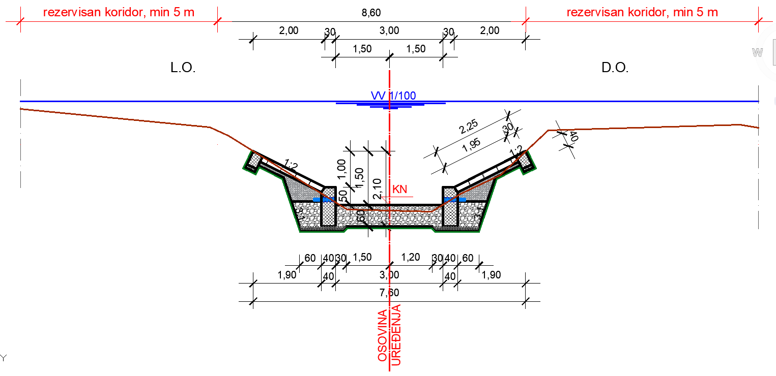
In addition to the works in the main river channel, it is planned to construct and rehabilitate embankments along the Glogovska River or to construct flood defence walls in areas with narrow corridors. This will allow a 80cm freeboard above the design flood flow of the Glogovska River (T=100 years return period) in the regulated state.
The Krizevica River
Option I: regulated main river channel with a base 7.50m wide and 1:2 slopes. Longitudinal MB30 reinforced concrete stabilizers, measuring 40x110cm, are used to stabilize the streambed and slopes of the regulated channel. The longitudinal stabilizers are placed at a right angle to the regulated channel, with their crown raised by 50cm above the bottom of the streambed.
Under longitudinal stabilizers, lining of reinforced concrete slabs and the final beam, there is a 10cm base layer made with gravel of maximum 1cm grain size. In order to prevent suffosion behind the river channel, geotextile with a mass of 300gr/m2 is installed on the previously prepared base under the gravel layer along the entire section of river training works.
Option II: regulated river channel has isosceles trapezoidal cross-section, with a base 7.50m wide and 1:2 slopes. Mechanically placed riprap is used for the stabilization of the streambed (1m thickness, stone size dsr=50-60cm). The final layer of stones is layed into 30cm layer of MB20 concrete and grouted. Slopes are stabilized to 1.50m height from the streambed, using mechanically and manually placed layer of stones of dsr=30-40cm size. The final layer of the slopes is a 30cm layer of stones additionally processed at the riverward side, manually placed and fitted so that after pouring MB30 concrete the absolute roughness does not exceed 5cm.
In addition to the works in the main river channel, it is planned to construct an embankment on the left bank of the Krizevica, with a 80cm freeboard above the design flood flow of the Krizevica (T=100 years return period) in the regulated state.
Protection of the right Drina bank
Two types of cross-sections are analysed to protect the left bank of the Drina River and the future embankment from potential bank erosion. Both types are variations of the continuous bank revetments made with crushed stone with a toe in the excavation. Figure 20 shows the selected option.
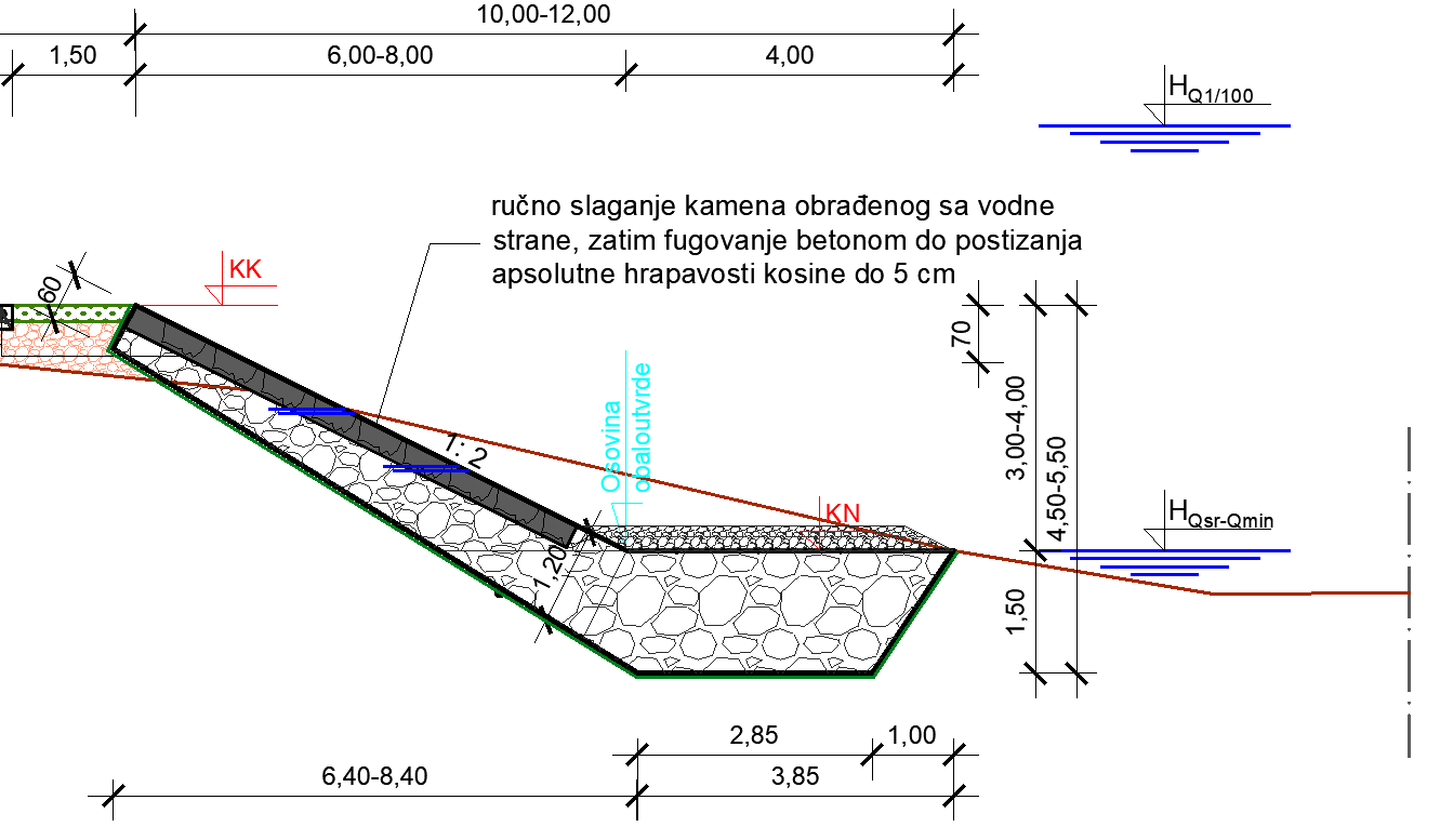
The selected option involves a construction of crushed stone revetment. The final layer is a 30cm layer of manually placed and fitted stone, additionally processed at the riverward side. This design also planned a 10m wide area which will be used for recreation and leisure activities (Figure 21).
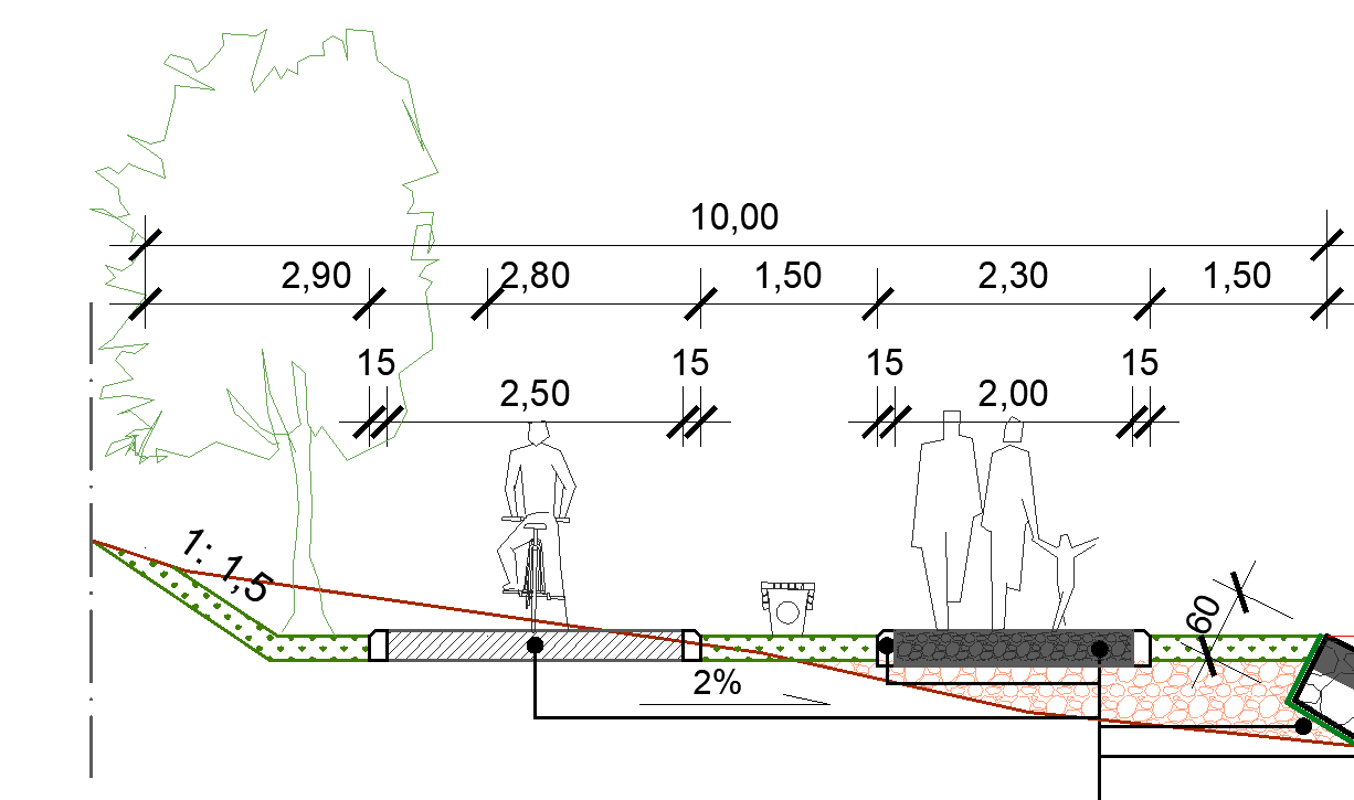
Option ‘b’ involves a construction of a terrace which will contain a stone path (2m wide and 30cm thick) and an asphalt bicycle lane (2.5m wide and 30cm thick), and subsequent spreading of top soil and grass, planting trees and installing benches.
-
-
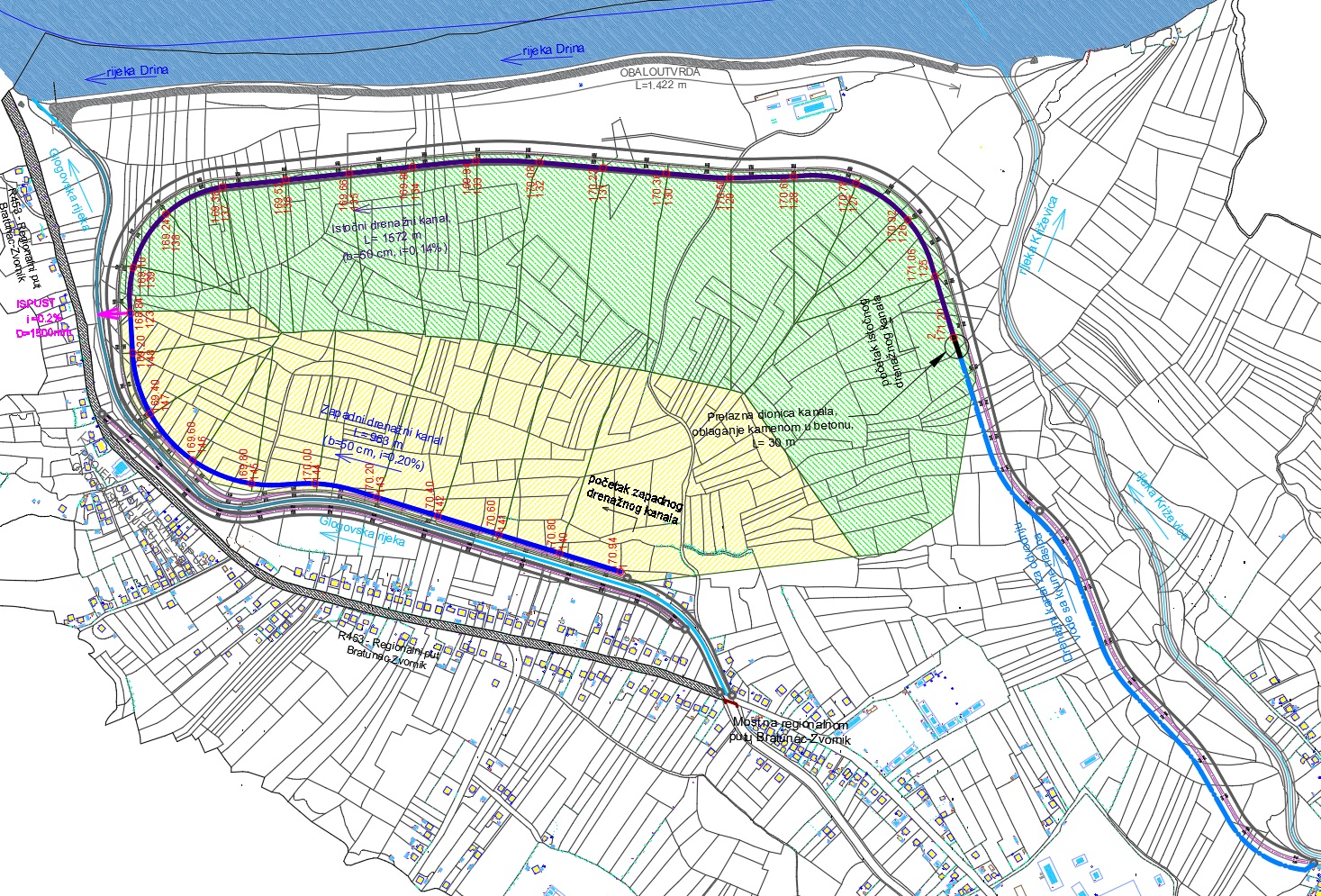
- Internal drainage
-
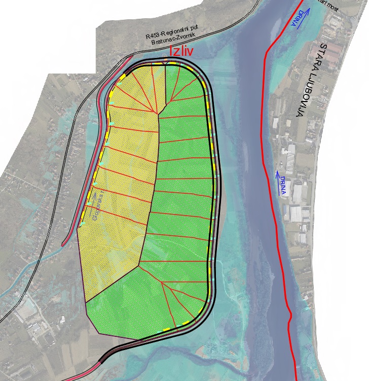
Depending on the receiving water body, the 73ha area is divided into the East and West drainage subsystems. The technical solution for the drainage of internal waters of the future protected polder includes the construction of main drainage structures along the designed embankments, as follows:
-
-
- Right embankment along the Glogovska River – Subsystem 1; and
- Left embankment along the Krizevica and Drina rivers – Subsystem 2 (Figure 22).
-
-
-
- Restoration of the Krizevica basin: Given its nature to flash flooding and transport of huge amounts of sediment, there is an obvious need to restore the Krizevica basin and to start implementing management measures as soon as possible. Restoration will include erosion control measures (erosion control barriers, afforestation, improvement of agricultural land) and prescribing a set of administrative measures for the catchment area;
- Restoration of the riparian area along the Drina, upstream from its confluence with the Krizevica: Given that it is planned to develop a new industrial zone and possible duty-free zone on the left bank of the Drina downstream from the Bratoljub new brige, it is also important to protect this area from overbank flooding by the Drina and Krizevica rivers, and flooding by runoff from hill sides and inland waters. This section starts at the confluence of the Krizevica and the Drina and ends upstream at the Bratoljub Bridge, where it is necessary to plan stabilization of the Drina river channel, construction of embankments along the Drina and Krizevica, and internal drainage of the future protected area.
-
-
-
- Detailed Design: Following the development of the Preliminary Design and conceptual technical designs, a synchronized preparation of maps/data and elaboration of technical details at the level of the detailed design was carried out in October 2020.
-