


Analyses of the Flood Wave Propagation in Case of “Nedavic” Dam Breach at the Section From the Dam to the Urban Area of Konjic
Investor: EFT HE Ulog d.o.o. Kalinovik
INTRODUCTION
Hydraulic analyses, especially those considering process of flood wave propagation in emergency situations for hydro power plants (dam overflow or breach) are very important since enable interpretation of hydraulic features of extreme hazards and risk of flooding the downstream sections of watercourses. In case of high dam breach, Investor’s obligation is to define key hydraulic parameters (flood prone area, velocity and time of the bow-wave arrival and flood depths) in order to undertake prevention measures such as alarming for timely evacuation of people and other beings and if neccessary assets within the flood prone area.
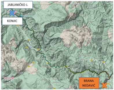
According to results of previously implemented analyses, flood wave was not completely transformed at the considered the most downstream profile, 22.655 km away of breach location. It means that it is necessary to implement analyses to the Jablaničko lake and to review dynamics of flood wave propagation on downstream section in additional length of c/a 33 km, and to reconsider impacts of such hypothetical event especially at urban part of Konjice, since planned “Bjelimici” HPP and Glavaticevo HPP, foreseen for the flood wave mitigation, were not constructed. At the present status that will last for certain time, it is necessary to supplement hydro dynamic analyses of the hypothetical dam breach for Ulog HPP, in order to analyse entire process of flood wave transformation to the complete mitigation of its impacts. Based on the results of implemented analyses, flood wave was not completely transformed
GOALS OF ANALYSES
Analyses of the flood wave propagation in case of the dam breach and results achieved, represent hydraulic base for development of the “Design of Alarm System” which should perform preventive information of endangered population on downstream area in case of hypothetical dam breach.
Updating of hydro dynamic analyses of flood wave propagation in case of “Nedavic” dam breach means preparation of appropriate bases and establishment of 2D hydrodynamic model of unsteady flow at the considered section, c/a 55 km long, of sufficient length of calculation domain for defining key hydraulic parameters for this calculation case.
Key task of hydrodynamic analyses is defining hydraulic parameters of the breach at the selected sections what includes following: flood prone area, levels, discharges, bow-wave propagation velocity and volume at the established domain of hydraulic analyses.
BASES
Appropriate bases are developed, and key inputs were achieved by increasing the reliability of geodetic survey – using DTM (hybrid digital terrain model) model which is verified through the surveys of cross sections, including bridges, cascades and parallel protection structures in Konjic.
Results of previous design and planning documentation were used for defining initial and limit conditions at the “Nedavic” dam section. This documentation was handed over to Zavod by Investor. The wave occurring due to “Nedavic” dam breach has maximum discharge- flood wave peak of 6.000 m3/s. For generating such wave and its propagation in the area immediately downstream the dam, Zavod used model PROLOM developed at the Institute for hydraulic and environmental engineering at the Civil Engineering Faculty, Belgrade. In the case of dam breach, superposition at the dam section was considered with the flood water of return period T=1000 years and average discharge at the dam profile Qsr.
Hydrological data were additionally collected and processed for the part of Neretva catchment area downstream of planned “Glavaticevo” HPP to the Jablaničko lake regarding:
- Spatial layout and key characteristics of the Neretva river sub-basins at the analyzed area according to data from the Neretva river basin management plans.
- Values of the total input of intermediate inflow of average and flood waters of Q20 and Q100 on Neretva to the Jablanica accumulation: Flood Hazard Maps and Flood Risk mass in Bosnia and Herzegovina: Report on hydraulic modelling – Subarea 1.
HYDROLOGICAL AND MORHPOLOGICAL AND HYDRAULIC ANALYSES
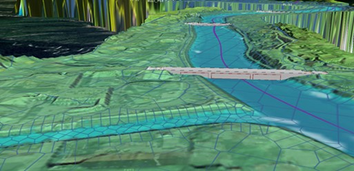
After analyzing and supplementing hydrological input data and limit conditions, 2 D hydraulic model was created- plain model of flow, having in mind that entire area of analyses is of non-prismatic river bed and significant river bed asperity changes.
This configuration of the river bed has complex natural conditions, therefore it is recommended to present those river bed conditions using multidimensional flow model (plane or spatial model). Plane flow character is important for considering flood wave transformation caused by dam breach, considering the key requirements such as exact defining of dynamics of flood wave transformation, time component of flood wave propagation and changes of hydraulic parameter such as discharge, velocity and levels along the watercourse.
Three calculation situations are considered i.e. hydrological and hydraulic scenario at the design area:
- Natural status + downstream flow contribution Q100:
- at the dam section Q100
- at the dam section Q1000
- at the dam section Q1000 + „breach”:
- downstream flow contribution Q20
- downstream contribution Q100
- at the dam section Qav + „breach” + downstream flow contribution Qav.
Testing and calibration of the model was performed based on simulation of natural flows for high calculation water of T=100 and T=1000-year return period at the dam section with superposition of flood water of flow contribution from the inter-basin of T=100 return period. Level of water within Jablanica accumulation was 266.50 m a.s.l. with flood waters values for Neretva and tributaries taken over from the Flood Risk and hazard maps for BiH, performing consideration of the inter-basin hydrograph proportional to the size of the river basin they occupy.
For simulation of the dam breach, upstream boundary condition is value of the hydrograph occurred as superposition of the dam “breach” and flow contribution from the inter-basin:
- Scenario 1 – flow contribution from the inter-basin flood water of T=20 return period,
- Scenario 2 - flow contribution from the inter-basin flood water of T=100 return period
- Scenario 3 – flow contribution from the inter-basin average flow (Qsr).
Scenario 3 can be considered as authoritative for interpretation of the flood wave transformation, with flow contribution of average water from the inter-basin and Jablanica accumulation level of 270 mm (it is more strict criterion for analyses of hydraulic parameters in Konjic) while for establishing alarm system, Investor is going to select Scenario that will be used.
RESULTS OF ANALYSES
Summary of “dam breach” results with flow contribution of average inter-basin inflow (as well as for other two considered Scenarios) was presented on 7 key profiles on considered Neretva section, where transformation of the flood way was performed (“Nedavic” dam, planned “Ulog” HPP – entity border line, „Bjelimići” HPP, „Glavatičevo” HPP, confluence of Šištica – Borački stream, Konjic – upstream and Konjic – urban, all the profiles are important, but Konjic-urban is distinguishing.
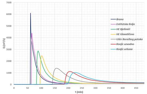
Transformation-mitigation of the peak flood wave on first 23 km upstream to the profile of planned “Glavatičevo” HPP is 62% and then on remaining 32 km of Neretva to Jablaničko lake additional 13%. Mitigation of the peak flood on the entrance into urban area of Konjic is 84% compared to “Nedavić” dam location.
Time for the flood wave transformation is significantly shorter on downstream profiles, due to hydrodynamic features of the watercourse, and varies between 120-169 min on profiles of “Nedavić” dam and “Glavatičevo” HPP while on the lower course it was longer and went between 240-266 min from the profile „Confluence of Borački stream” - Šištica to profile „Konjic urban”.
Time of the peak flood wave occurrence in the area of Konjic was 146 min from the moment of dam breach on profile “Konjic upstream” and 166 min on profile “Konjic urban”.
Transformation of the flood wave after “Nedavić” dam breach in peak flood wave is 1.024 m3/s on “Konjic-urban” profile. This is transformation i.e. mitigation of the peak flood wave for c/a 85% and value of the peak is less then calculation flood waters of T=100 return period, which in natural status amount to 1.160 m3/s. it means, that regarding flood consequences, section “Konjic-urban” is on the most sensitive section of Neretva river course, according to key parameters of hydraulic analyses during peak flood wave occurring due to hypothetical “Nedavić” dam breach (level and depth of water, including volume of flooding), negative effects of designed hypothetical accident – Nedavic dam breach are milder compared to situation in natural status without breach of mentioned dam, for hundred year return period flood, irrelevant to the water level in Jablanica accumulation.