

Title: Development of Hydrological Flood Forecasting Model for Sava River Basin (River Basins of Bosna, Ukrina, Brka and Tinja)
Investor: European Commission, 2019-2020
INTRODUCTION
After devastating floods in the Sava river basin, which hit B&H severely, there were several flood early warning systems developed. Real time flood forecasting model for river basins of Bosna, Ukrina, Brka and Tinja is continuation of work of team of experts and external associates of Zavod za vodoprivredu toward development of this type of operational flood protection system.
While Bosna river basin is covered with numerous hydrological and meteorological stations for calibration and launching of the models which are archived into the forecasting system, hydrological and meteorological stations on basins of Ukrina, Brka and Tinja are rear, so to speak nonexistent. Especially hydrological stations and historical observations are missing, thus making those river basins unstudied.
In the flood forecasting system, hydrological and hydraulic models are vital tool for forecasting permanent flood status and represent base of the forecasting model platform. Those models usually are calibrated based on observed meteorological and hydrological data. When river basins do not have observation network, establishing reliable real time flood forecasting becomes extremely challenging. One of the solutions includes rationalization of model parameters with included certain classification of the basin for the purpose of considering similarities of two or more basins. Other approach rely on physically based hydrological models, but even for those, it is necessary to perform some kind of calibration / adjustment of model parameters.
For the needs of this project, for the part of the project area on basins of Ukrina, Tinja and Brka the methodology used during establishing flood forecasting river basins for unstudied basins was used, according to principle to use data from studied Bosna river basin for calibration of hydrological model parameters and definition of regression models between calibrated parameters and certain physical and morphological features of the basin.
Simulation data obtained are compared with regional flow duration curves during the phase of methodology validation. Hydrological values are additionally checked in the phase of hydraulic modelling, comparing collected data on flood events in sense of achieving and genesis of flooding, representing iterative approach with the aim of establishing reliable hydrological and hydraulic model as base of real flood forecasting model.
After establishing and verification of flood forecasting model on basins of Bosna, Ukrina, Brka and Tinja it was connected with existing forecasting models of Una with Sana and Vrbas to the common platform with hourly prognosis outputs for the next four days.
AREA OF THE REAL TIME FLOOD FORECASTING AND AVAILABLE DATA
Real time flood forecasting system consist of four river basins, namely Bosna, Ukrina, Tinja and Brka river basins (Figure 1).
Bosna river basin was not in the Zavod's scope of activities, it was just that the results of calibration of hydrological model of Bosna sub-basin (optimized parameters for regionalization) were used for determination of parameters for unstudied river basins of Ukrina, Tinja and Brka.
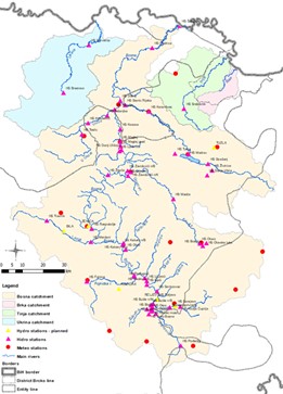
Ukrina, Tinja i Brka (UTB) are right Sava tributaries, with total area of 1500 km2, 950 km2 and 233.2 km2, respectively (Figure 2).
Hydro-meteorological data collected for the project area mostly relate to the precipitation values.
For the Tinja river basin, there is only one hydrological station (HS Srebrenik) in upper and mountain part of the basin.
HYDROLOGICAL MODEL
NAM hydrological model based on deterministic, conceptual model precipitation – runoff was used for the needs of hydrological modelling for selected basin in the project area.
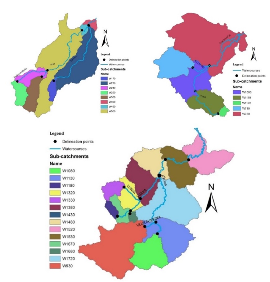
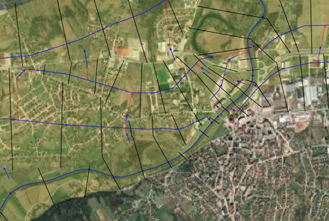
At the initial modelling phase, Tinja river basin was divided on two sub-basins on HS Srebrenik. Since the runoff was registered at the Srebrenik station this part of the basin was automatically calibrated using auto-calibration tool presented in NAM hydrological model. The rest of the Tinja river basin, as well as entire river basins of Ukrina and Brka, were calibrated based on suggested methodology. For the needs of combined hydrological and hydraulic modelling, those basins had to be divided into several sub-basins where it was necessa5ry to define hydraulic flow contributions. Division of basins was presented on Figure 3.
Ukrina is divided on 14, Tina on 5 and Brka on 8 sub-basins. The interval of calculation for simulation for all models is one hour. When available, hourly data have been used. Otherwise, daily data interpolate under presumption that precipitations are equalized during the day.
Before start of the calibration procedure for unstudied river basins, analyses of model parameters sensitivity which is implemented with the full version (all parameters) of NAM model was performed. Sensitivity has been analyzed on measured section of the Tinja basin, to the HS Srebrenik, maintaining 11 parameters constantly, while the scope of the one being analyzed to sensitivity is changed for 20%. For each change of parameters, simulation is being implemented and efficiency calculated. When this efficiency is presented compared to each parameters value from predefined scope, impacts of changes of parameters value to the model performances is clearly visible. If the efficiency is changing in smaller scale, no matter of given value of parameters, those parameters are insensitive, i.e. do not have impacts to model results and there is no need for calibration. On contrary, when small changes of parameters cause significant changes of model efficiency- has powerful impacts to model simulation results, the parameter is considered as sensitive. It means that those parameters are important for the process of modeling and that they have to be calibrated.
According to available data, period selected for calibration and validation of model is 2008-2014, taking the year 2008 as hot start period. General recommendation for calibration period is at least 5 years, therefore calibration period is 2007-2013, while year 2014 was used for validation of model (validation of results in independent year except calibration period).
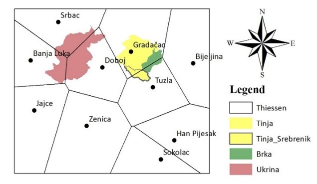
In order to calibrate unstudied basins, its behavior regarding runoff generation mechanism is transferred from measured basins via process of regionalization. In this process, similarities between basins have great role under assumption that surrounding basins act on hydrologically similar way. Basic principle for river basins similarity is spatial vicinity between basins while best results are gained by combining approaches of spatial vicinity and river basin attributes as applied in the project.
HYDRAULIC MODEL
For all three Sava tributaries, MIKE 11 and MIKE FLOOD hydro-dynamical models were used for watercourse simulations and discharges along watercourses during simulated flood events. Software MIKE 11 solves complete 1D equations of nonstationary flow, and quasi 2D approach is simulated by connecting 1D watercourses, i.e. by establishing parallel branches.
Quasi 2D approach is applied for simulation of nonstationary flow along Ukrina, Tinja and Brka. Numerous river branches, and according to that, channels connecting them internally and with the main channel together with several types of limiting and internal conditions, are used for simulation of complex flow pattern during flooding events.
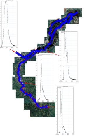
On figure 4 there is small part of calculated domain of Ukrina river presented, the one covering Derventa city. Junction channels simulate dyke overflow. It is clear that this method can be applied just if border conditions overlapping are not considered.
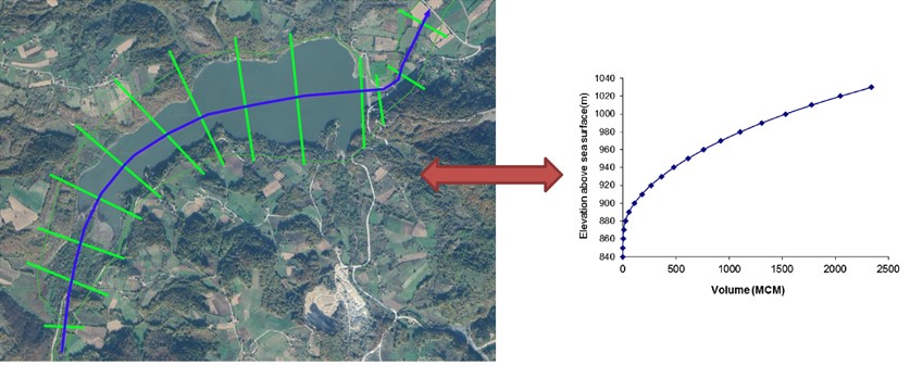
One of the most challenging tasks in the process of modeling would be inclusion of effects of Drenova accumulation (Drenova river-tributary of Ukrina) to flood wave transformation. Reservoir geometry – accumulation is simulated as fictive cross section which reminds to the curve of Drenova reservoir volume-height (Figure 5).
Level charts are defined for downstream ends of Ukrina, Tinja and Brka rivers i.e. appropriate Sava river levels. Absolute height of water surface on those locations are result of interpolation of levels on appropriate meter stations along Sava.
RESULTS OF HYDROLOGICAL AND HYDRAULIC MODELLING
18 sub-basins in total are used from Bosna river basin for validation of model on basins of Ukrina, Tinja and Brka.
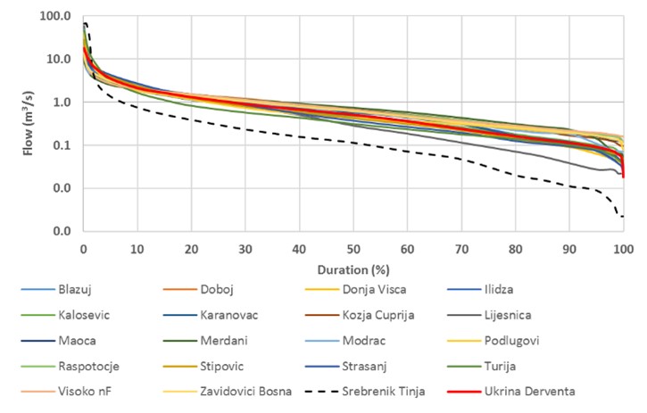
On Figure 7 there are standardized (divided with mean discharge) flow duration curve for 18 sub-basins which are similar for its attributes with basins of Tinja, Ukrina and Brka.
Results of hydraulic modelling have pointed out the need for specifying some parameters of sub-basin of NAM model with the aim of increasing the runoff. Therefore, those parameters are adjusted in details for all sub-basins which are located downstream of HS Srebrenik in Tinja river basin while simulated water levels do not approach historical flood volume.
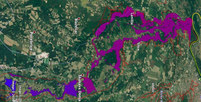
Figure 8 presents calculated flood zones for the finishing calibration process compared to maximum registered historical floods.
REAL TIME FLOOD FORECASTING
Through the contacts with the main project beneficiaries, details of the software environment are harmonized for the modeling system that will give flood forecasting. Primary, flood forecasting system integration should have been provided for Bosna, Ukrina, Tinja and Brka with activities implemented simultaneously on systems for Una, Vrbas and Sava.
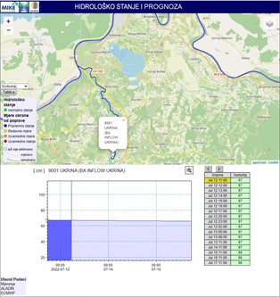
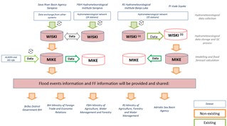
Adopted system for data management and system assistance regarding hydro-meteorological data in real time is WISKI.
Regarding data required for forecasting model operation, i.e. development of the prognosis, they are distributed into three main categories of input data:
- Meteorological data, include data on air temperature and precipitation quantities, from the filed stations, sending information according prescheduled scheme (hourly) as solved with WISKI software tools;
- Hydrological data, including water table and runoff data, from field stations, sending information according prescheduled scheme (hourly) as solved with WISKI software tools;
- Data on forecasting, i.e. forecasted precipitations (Aladin, ECMWF) which are handed over on the state level based on bilateral and international agreement
Managing entire forecasting system is performed with software tools MIKE Operations, while on figure 9 there is distribution of main software packages for getting data on forecasted flood values.
Development of hydrological flood forecasting system resulted with development of system that can give flood event forecasting for river systems of Bosna, Ukrina, Tinja and Brka. System (Figure 10) was successfully installed on servers of Agency for Sava watershed area in Sarajevo and PI “Vode Srpske” in Bijeljina.