


TG 27 – DEVELOPMENT OF THE DETAILED DESIGNS (PRELIMINARY AND DETAILED) FOR FLOOD PROTECTION MEASURES ON THE NORTHWEST OF REPUBLIKA SRPSKA (SANA, GOMJENICA, OBODNI KANAL AND BUBNJARICA)
Terms of Reference, defines the scope of works and tasks for development of the Preliminary and Detailed design PM 899.1 Drainage channel – flooding of Sava in center of Prijedor”. Terms of Reference is divided into two parts with the target to develop Preliminary design for construction of the Boundary channel for protection of source “Tukovi-Matarusko polje” against flood waters from Mataruga hill slopes and flood waters of Sana which would be located from the confluence of Sana and upstream along the Mataruga hill slopes, on section 5.286 km long. By the Contract annex and with Investor’s approval and after harmonization of the Minutes, development of the Preliminary designs was foreseen as follows:
- Internal drainage in “Mataruško polje” protected area, surface of 765 ha on the left Sana bank and
- Regulation of the water regime on Sana for 2 km upstream from the City Bridge and c/a 8 km downstream.
Based on Preliminary designs following Detailed designs were developed:
- PM 899.1a – Boundary channel, section of 5.286 km;
- PM 899.1b – channel on the toe of existing dyke on Sana, section of 0.58 km;
- PM 899.1c – Dyke on the left Sana bank, section of 2,287 km;
- PM 901 – Maintenance of the streambed of Gomjenica river, section 17.00 km long.
Due to its complexity and volume, and in accordance with ToR, entire project documentation was organized in several Books and Volumes:
- Book 1: Summary Report with general documentation TG27;
- Book 2: PM 899.1 Drainage channel – flooding by Sana in Prijedor center; PM 899.1a – Boundary channel;
- Volume 2.1: PM 899.1a Boundary channel – Technical solution;
- Volume 2.2: PM 899.1a – Boundary channel - objects, structural part;
- Book 3: PM 899.1 Drainage channel – flooding by Sana in Prijedor center; PM 899.1b – Channel at the toe of existing dyke on Sana
- Book 4: PM 899.1 Drainage channels – flooding by Sana in Prijedor center; PM 899.1c – Dyke on left Sana bank;
- Book 5: PM 901 – Maintenance of the Gomjenica streambed.
- Book 6: PM 909 – Concrete channel and pipeline – flash floods in Bubnjarica stream; PM 911 – Dredging of the channel – flash floods in Bubnjarica, Kostajnica; PM 913 – Control of drainage, dyke along Una which serves as the road;
- Volume 6.1: PM 909 – Concrete channels and pipelines- flash floods in Bubnjarica stream;
- Volume 6.2: PM 911 – Channel dredging – flash floods in Bubnjarica stream, Kostajnica;
- Volume 6.3: PM 913 – Control of drainage, dyke along the Una river which serves as the road;
- Book 7: Safety at work and Fire protection Studies for TG27 project.
In Books 2,3,4,5 and 6 – Detailed technical solutions are presented at the level of the detailed designs arranged in logical units as follows:
- Book 2. Boundary channel:
- Volume 1. Technical solution,
- Objects, structural part;
- Book 3. Channel at the toe of existing dyke on Sana;
- Book 4. Dykes on left Sana bank.
- Book 5. Maintenance of the Gomjenica streambed.
- Book 6 has covered three project measures on Kostajnica municipality. In each individual volume there are technical descriptions of constructions on designed object, bill of quantities, calculations, technical specifications for implementing works and priced bill of quantities.
PRELIMINARY DESIGNS
"Book 2: PM 899.1 Drainage channels – flooding by Sana in Prijedor center, PM 899.1f – Regulation of the Sana water regime upstream of city bridge section 2 km long and downstream for c/a 8 km long section with internal drainage in protected area of “Mataruško polje”, surface of 765 ha on left Sana bank”
“Volume 2.1 Regulation of the water regime of Sana for 2 km upstream of city bridge and c/a 8 km downstream”
Hydraulic analyses of regulated channel of Sana river in Prijedor implies conclusion that protection against flood waters should be designed for 100-year flood waters with raising the dyke for 80 cm, on existing regulated streambed and constructed accessory dykes and parapet walls.
If the flood protection on Sana would be based just on construction of dykes and parapet walls without regulation of the streambed, it would mean that this type of protection would imply increase of flood water level in Prijedor central city core for c/a 80 cm compared to the existing status, therefore insisting on continuation of dyke construction downstream of city bridge on both banks would reduce protection level on existing constructed dykes and parapet walls upstream of bridge in the city.
The conclusion of above-stated considerations is clear – flood protection of Sana in Prijedor city urban area has to be foreseen simultaneously with construction of parallel objects outside minor river bed banks and with regulation of minor bed and construction should be foreseen in phases according to priorities having significant effects to reduction of flood risk at the designed area. Spatial and planning documents should consider not just corridors required for implementation of investment flood protection measures but with non-investment measures in the sense of planning-land use, construction types and other segments, in potentially flooded area to reduce flood risk for population and economy.
Flood risk and flood hazard of Sana river for the urban area of Prijedor, according to Preliminary design and implemented hydraulic calculations, is estimated as high and extremely high. Having in mind Prijedor City as one of the four biggest cities in Republika Srpska, it has realistic abilities for further urban expansion and increasing of economic and urban activities in mapped flood area it can be concluded that it is necessary to start aimed and very requiring measures on flood risk mitigation in order to create preconditions for planned development of the city, but also for protection of population and its material assets on already urbanized area.
Respecting general observations and guidelines from the above-mentioned document, and based on ToR the Preliminary solution has been developed for regulation of water regime and Sana river channel through the urban area of Prijedor, which foreseen regulation of Sana river bed in length of 14.5 km
- Preliminary design presents integrated technical solution of Sana river regulation, systematic flood protection measures but also reconstruction and rehabilitation measures for upgrading flood protection objects, as well as planning measures and guidelines which has the aim of increasing the efficiency of flood protection at the urban area of Prijedor city.
- Technical solution and flood protection concept for Sana in Preliminary design is processing following:
- Protection level. For regulation of the streambed and Sana water regime in the project area from the bridge in Brezičani and upstream to the bridge in Zeger, 9.9 km long section suggest 100-year flood protection in regulated status of the streambed with raised dyke for 80 cm compared to calculated water. Designed raised dyke enables discharge of 500-year Sana flood water. Downstream of bridge in Brezicani, except on right bank where urbanized in the part from the bridge to the trunk road Prijedor-Novi Grad and where construction of accessory dyke is foreseen on 1.270 m long section it is not foreseen to construct dyke objects and parapet walls but inundation area is left as reserve for flood water transfer after regulation of the streambed. This practically means that in part of Cikotsko polje and left Sana bank, downstream of railway bridge in Brezicani the area is adjusted to activities which are appropriate to temporary flooding (agriculture, sport and recreation ….)
- Route of regulated river bed. Layout solution of Sana river bed regulation through the urban area of Prijedor, from Cikotsko polje and upstream to the bridge in Zeger, section 14.5 km long on his base of regulated river bed is designed by the route of existing river bed status. For entire part of regulation the route was aligned on the regulated riverbed axis and axis of the flow regarding designing or required bends and intermediate directions.
- Longitudinal section. Level of Sana riverbed regulation on the project area has ambiguous fall, overcoming grade separation of DH=6.13 m on section L=14.270.79 m, therefore average fall of designed level of regulated channel value is I=0.43 ‰.
- Standard section. Design solution, depending on the level of existing and foreseen urbanization, adopts two types of regulated Sana river channel, urban and natural type. Types of regulation are selected concerning the expected hydraulic effects, limitations of the regulation works corridor due to intense urbanization of costal area within the city. Beside indicated effects of regulation the effect of removing all “bottle necks” has to be achieved. One of targets for section of standard profile is creating mechanism for stopping the permanent trend of “degradation” of inundation belt, but also of water property disturbed with permanent objects. Within the standard profile it is possible in the next phases to plan ambient arrangement and sport and recreation elements.
- Implementation priorities. Since those are very complex and requiring regulation works for the entire area of Preliminary design, needing substantial financial support, project defines phases of regulation works implementation. Multi-criteria analyses confirms practice of implementing works from downstream to upstream phase, except Phase “I”. As priority the Phase II was marked (upstream of bridge in Brezicani) where most of the works refers to works in streambed and construction of the right dyke thus creating possibility for flood protection of significant surface in hinterland which can be urbanized having in mind how close the Prijedor city center is. Immediately after Phase II, the Phase III continues where implementation of works on river bed regulation and construction of parallel objects achieves flood protection level in Prijedor city and at the same time due to value of material assets and thick
- Technical solution and flood protection concept for Sana in Preliminary design is processing following:
Population density at the right bank and huge agricultural area of Matarusko polje and eliminate biggest risks of flooding. Works at this phase require more significant property issues on expropriation works on banks and achieve extraordinary effects to flood risk mitigation for entire project area. After regulation works are implemented to the city bridge, flood risk will be reduced to acceptable level, while continuation of river bed regulation on downstream phases hydraulic image of flow is regulated with effects of additional mitigation of the flood risk. This also provides conditions for urbanization of parts of wider inundation belt after construction of dyke and parapet walls.
- Synchronized and gradual construction of protection objects. It is necessary to respect synchronized construction and stages of construction and enable equal protection for urban elements at the left and right banks of Sana. Constructing the dyke, without regulation of the streambed (which increases discharge capacity of minor bed and flood water maelstrom) flood water level is raised therefore construction of protection objects has to be performed simultaneously and with combined regulation of minor bed and construction of accessory objects on banks.
- Upgrading the spatial documentation. According to technical solutions from this documentation, it is necessary to perform upgrading of Spatial and Urbanism pan (Regulation plans) and reserve the corridors for construction of Sana protection objects and hilly and internal waters of Matarusko polje.
- Key elements for detailed designs are defined. Preliminary design defines key parameters and elements (levels and constructions of dykes, parapet walls, standard profiles, minor bed etc.) for development of the detailed design on any section of the area within this documentation.
- Other planning and water management instructions. Beside above mentioned final considerations and guidelines directly pointed out by interpretation of design solutions, for the next planning period it is necessary to consistently apply other important notes, regarding direct implementation of technical solution but due to great importance within the flood protection domain they are stated already in Preliminary design, such as:
- Technical solution of Sana establish appropriate discharge profile of minor bed and measures for maintenance of required dimensions of major bed. After updating spatial and planning documentation it is necessary to perform expropriation of the land which is not within water property, i.e. which is private or state property.
- After regulation of Sana river bed, it is necessary to perform maintenance of the river bed of Sana and dredging according to plan in order to maintain design discharge capacity of minor bed profile. Removing of sediment from the Sana bed is one of the most important activities which has to be implemented by plan after Sana river bed regulation has been performed on this area according to principles and Strategy of sustainable Sediment management.
- In Preliminary design, requests and principles of flood protection have been entirely respected, as regarding level so regarding protection reliability. According to recommendations from Preliminary design it is necessary to continue design activities to the downstream sections of Sana but also on implementation of the detailed designs according to defined implementation phases.
Beside design and construction activities on river bed and Sana river banks regulation it is necessary to consistently apply other protection measures on discharge capacity of Sana. Surface occupied by existing river bed and additional corridors required for regulation of water regime should be included into original purpose-retention area for acceptance and transfer of Sana flood waters in flood water periods, in the first phase by stopping further construction and foreseen regulation works, and then in next phases to remove permanent contents which disturb transfer of Sana flood waters. Competent institutions and Public institutions which issue agreement and permits for construction have to respect principles of watercourse protection and stop issuing any document which stimulate construction in minor and major river bed.
- General overview of required phases on project activities implementation on flood risk mitigation. Development of the detailed design should be started in the next period as defined in priorities of gradual implementation of Sana river bed in order to create preconditions for implementation of works and reduction of flood risk on the area of Prijedor. Final designs of water regime and Sana river bed in the area of Prijedor. Detail designs of water regime regulation and Sana river bed in the area of Prijedor should be divided into logical units – implementation phases where all the elements and technical solutions of flood protection and possibilities of ambient organization of Sana river are going to be reconsidered.
Detail designs with investigation survey and engineering and geologic/geo-technical works should be implemented according to the following schedule and project documentation titles:
- Detailed design of Sana water regime regulation for the urban area of Prijedor nearby railway bridge in Brezicani and upstream to the meander in Raskovac, section 3,25 km long, including internal drainage between trunk road and regulated Sana river bed,
- Detailed design of Sana river bed regulation on urban area of Prijedor from meander in Raskovac and upstream to the city bridge, section 2.7 km long including internal drainage and flood protection of river island “Stari Grad”,
- Detailed design of upgrading and reconstruction of flood protection system and Sana water regime regulation in the urban area of Prijedor, from the city bridge and upstream to Gomjenica confluence, section 1.35 km long,
- Detailed design of Sana water regime regulation on wider area of Prijedor city, from Cikotsko polje and upstream to bridge in Brezičani, section 4.5 km long,
- Detailed design of Sana water regime regulation on wider area of Prijedor, from the confluence of Gomjenica into Sana and upstream to the bridge in Žeger, 2.6 km long,
In parallel with Detailed designs development, designer should start with the development of Preliminary design of flood risk reduction against hilly and internal waters for the areas of systems Gomjenica, Orlovaca, Cirkin polje and Puharska:
- Preliminary design of “Gomjenica” subsystem drainage, area of c/a 580 ha,
- Preliminary design of internal and hilly waters drainage for the “Orlovaca” subsystem, area of c/a 1.300 ha,
- Preliminary design of internal and hilly waters drainage of “Puharska” subsystem on the area of c/a 130 ha including also regulation of Puharska rijeka water regime on section c/a 3,2 km long,
- Preliminary design of internal and hilly waters drainage of “Cirkin polje” subsystem, area of c/a 147 ha,
After development of the above mentioned Preliminary designs, development of detailed designs of internal drainage regulation for mentioned subsystems on territory of Prijedor city was initiated, including “Mataruško polje” subsystem and within project measure TG27 preliminary design of internal water drainage was developed.
"PM 899.1f – Regulation of water regime of Sana of 2 km upstream from city bridge and downstream c/a 8 km long section, with internal drainage in protected area of “Matarusko polje” area of 765 ha on the left bank of Sana”
"Volume 2.2 – Internal drainage in protected area of “Mataruško polje”, area of 765 ha on the left Sana bank"
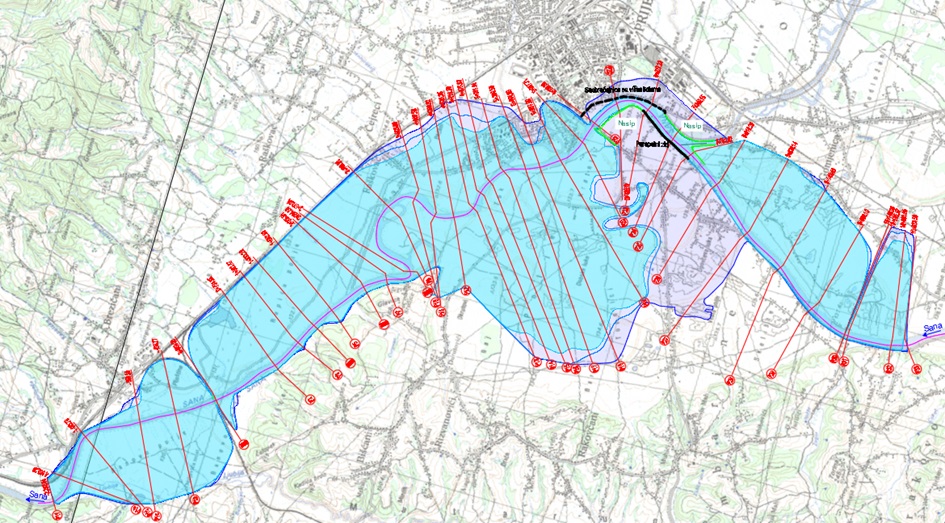
Melioration area “Matarusko polje” of 765 ha is located on the left bank of Sana in Prijedorsko polje. From the northeast and southeast is limited with Sana watercourse and on the northwest and southwest with Mataruga hill slopes. Against flood waters of Sana and hilly waters coming from Mataruga hill slopes, in melioration sense, it is protected by constructed and newly designed flood protection objects as follows:
- On the northwest, dyke along Sana was constructed upstream of city bridge, section 0.58 km long and concrete parapet wall was constructed upstream of dyke section 0.70 km long, or in total protection objects in length of 1,28 km;
- Detailed design (PM 899.1c – Dyke on the left Sana bank) on northwest, construction of dyke on the left Sana bank from the confluence of Boundary channel into Sana and upstream to the city bridge, section 2.287 km long;
- On the northwest and southwest of melioration area, Detailed design (PM 899.1 – drainage channels – flooding of Sana in Prijedor center - PM 899.1a – Boundary channel) construction of Boundary channel was foreseen on length of 5.286 km, from the confluence with Sana and upstream to settlement Habibovici, 5.286 km.
Construction of Boundary channel and dyke on the left bank of Sana in melioration sense, Matarusko polje melioration area will be completely protected against external waters;
Protected area of Matarusko polje is foreseen for the 100-year flood protection with super elevation of the protected objects for 0.80 m. Protection against internal waters is designed for daily precipitation of 5-year return period, therefore average hydro module of drainage in designed day is qd = 1,29 l(S.ha). In protected area of agricultural area it occupies 70% of the land (c/a 535 ha) and the rest is construction land. In the area there is narrow and wider protection area of the source “Tukovi” from which water is supplied for Prijedor.
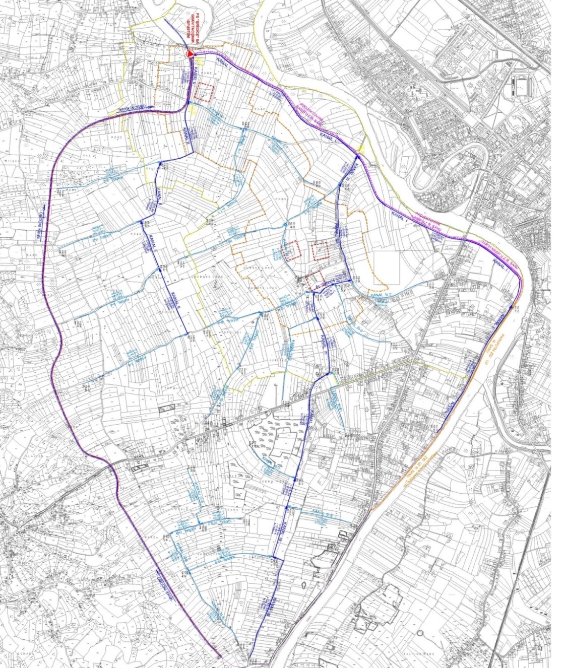
For protection against internal waters within protected area, the network of open drainage channels was foreseen on entire length of 23.000,54 m, therefore average thickness of channel network amounts to 30.07 m/ha. Network of drainage channels consists of: Main channels in length of 9.802,20 m, secondary and tertiary channels in length of 13.204,34 m.
Retention capacity of channel network is of 28.500 m3 and enables installation of drainage system on large plots of land. Gravitational outlet of water from the drainage network continues while Sana water level is lower than 131.50 m a.s.l. For water levels of 131.50 m a.s.l and higher, internal water transport from discharge network is performed over pump station;
On 765 ha of melioration area, along the road network, it was foreseen to construct new road network in length of 23.00 km, for the road network density of 30.60 m/ha. For crossing of the road network over channel network it was foreseen to construct outlet objects, average clear opening of φ 500 mm, average length of 8,00 m, for achieving shorter transport lengths towards channels and settled areas. It was foreseen to construct 86 outlet objects;
“Sredice” Pump station object was foreseen on the plateau of 27.00 x 35.00 m for the level of 132.50 m a.s.l. Pump station object is divided on two parts, underground and above ground part. Underground part is of 129.22 m2 and divided into parts, pressure with pump aggregate and gravitational part. Aboveground part is of 73.50 m2 where mechanical equipment room is located, command room, technical room and room with electro installations. It was foreseen to install two submerged vertical pumps into pump station, of installed capacity of Q = 535 l/s and pump head of 4.8 m.
"PM 899.1 DRAINAGE CHANNELS – FLOODING BY SANA IN CENTRE OF PRIJEDOR"
"PM 899.1a – Boundary channel"
Flood risk from Sana river and its tributaries in the area of Prijedor city, according to strategic document in the water sector for Republic of Srpska “Preliminary assessment of the flood risk on Republika Srska territory” from June 2014 from the aspect of historical and potential waters, is estimated as extremely high and risky.
Respecting general observations from the stated document, and based on ToR, Preliminary design „PM899.1 Drainage channels-flooding from Sana river in Prijedor center, PM899.1a Boundary channels” on the left bank of Sana river in Prijedorsko polje, for protection of source Tukovi-Mataruško polje, from great run off waters from the Mataruga hill slopes, Boundary channel on length of 5.308 km.
Integrated technical solution of Tukovi source area protection against great run off waters from Maturuga hill and Sana. This creates all planning preconditions for development of the detailed design for protection of Tukovi source against flood hilly waters and Sana river. Main guidelines and final conclusions regarding Preliminary design are as follows:
- Preliminary design of the Boundary channel construction in Prijedorsko polje, on the left Sana bank, for protection of Tukovi source area – Matarusko polje against great run off waters from the Mataruga hill slopes and great runoff waters of Sana, 100-year range of occurrence.
- Within hydrological maps, additional regional analyses were performed of great runoff waters from Sana and Boundary channel, in order to determine completely harmonized calculated flood waters on foreseen water management profiles for construction of Boundary channel for protection of Tukovi source area in Prijedorsko polje and construction of protection objects along Sana for protection of Prijedor city against Sana flood waters.
- Additional regional analyses identifies that calculated value of 100-year water from Sana, upper limits of confidence interval of 1.100.2m3/s, and it is compared to the present calculated value of Sana flood water in Prijedor city, range of occurrence Q1/100 = 944 m3/s, and 100-year water of Sana is significantly higher for 166.20 m3/s. Calculated value of 100-year water was also identified for boundary channel at the confluence with Sana, upper limits of confidence interval of 13.16 m3/s.
- For the selection of the boundary channel route on site, basically two options are considered and analyzed: Option “A” and option “B”.
Option „A“
During prospection of the boundary channel route (on 20.04.2018) position of the route on site was considered and at the same time the route was drawn on topographic map in scale R-1:2 5000. During alignment of the route on site, it was concluded that corridor of the route and constructed residential objects are not crossing each other neither with objects of agricultural production and satisfy other cultural conditions for route installation.
After drawing the route of Boundary channel and surveyed cross sections on topographic map in scale R-1:2 5000, due to local regressions in terrain, on several occasions the route of the boundary channel on cross sections was changed in the base, in order to get equalized slope of the route of Boundary channel towards Sana. As the result of changing the base of the channel route on cross section in base, the result was boundary channel route for Option “A”. As optimum solution with appropriate slope of the route toward Sana.
Route of the boundary channel (Option “A”) is aligned immediately under the Mataruga hill slopes, and goes from the confluence with Sana (St.0+000.00) and upstream to Donja Mahala settlement, in length of 5.308 km. Route of the boundary channel is run by free surface, by corridor without constructed residential or agricultural objects, and that there will be no need for moving or dislocating population, just solving property issues for expropriation procedure.
Option „B“
At the meeting, which was held in Prijedor (on 20.04.2018) when prospection of boundary channel was performed on site, regarding future optional solutions of boundary channel route it was concluded that due to constructed residential and agricultural objects there are no such possibilities of creating various options for the future required corridor of Boundary channel.
Due to indicated status and conditions on site, for installation of the new boundary channel route as well as optional solution (option “B”) route of the Boundary channel of Option “A” was used as base.
-
- Selection of the standard profile of Boundary channel regarding static hydraulic hydro-geologic and geo-mechanical stability of Boundary channel. Form and dimensions of the standard profile of Boundary channel are selected according to expected hydraulic effects, then to expected hydro-geological and geo-mechanical characteristics of the Boundary channel route on site, for setting the Boundary channel object, therefore there is no realistic possibility of construction of Boundary channel from the local natural soil material since this is about natural construction of Boundary channel with ecological aspects of regulation.
Based on the above stated expectations, following types of standard profiles of Boundary channel are analyzed:
Standard profile „Type 1“
This type of standard profile of Boundary channel is of nonsymmetrical double trapezoidal shape which has Boundary channel river bed in profile and on the left and right channel bank, depending on optional solution, it has accessory dyke. Between bed of Boundary channel and accessory dyke, foreseen road shoulder is 5.00 m wide at the level of natural terrain.

Accessory dyke which is on the left and right bank of Boundary channel, depending on variant solutions, has shape of single trapezoid.
On the external side of dyke, the access dirt road was foreseen which is compressed.
Standard profile „Type 2“
This type of standard profile of Boundary channel according to external shape, construction and elements on dyke and around the dyke is identical to standard profile of Boundary channel “Type 1”.
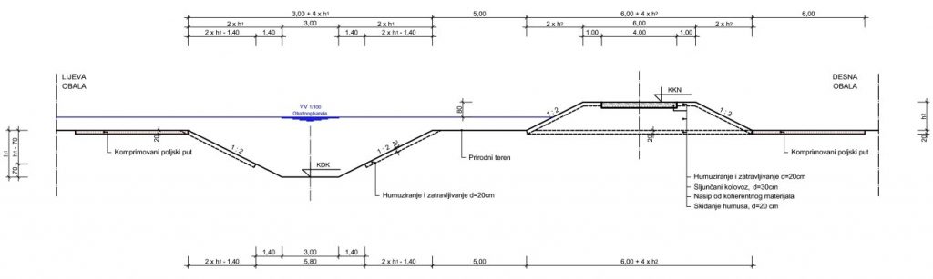
Basic difference between standard profile of Boundary channel “Type 1” and “Type 2” is that standard profile of Boundary channel Type 2 at the bottom of the bed does not have revetment in cement mortar.
- The following criteria were set for the ranking of the technical solutions of the Boundary Chanel, Variant "A" and Variant "B":
- From the geological aspect, that the route of the Boundary channel is laid on stable geological formations, which are not prone to sliding and deformations, which ensure the hydraulic and static stability of the Boundary channel,
- According to the length of the Boundary channel, that the route of the boundary channel is as short as possible,
- That during the construction of the Perimeter Canal, which provides the source zone of Tukovi-Mataruško polje from the large run off waters from the slopes of the Mataruga hill, the level of protection against hundred-year waters, as little soil material as possible should be incorporated.
- When expropriating land, the smallest possible area of land should be occupied by expropriation.
- Construction costs of the Boundary channel should be as low as possible.
It can be stated that Variant "A" has more favorable conditions for the implementation of the system of protection of the source of Tukovi-Mataruško polje than Variant "B", and that Variant "A" is proposed for the development of the Preliminary Design and the Final Design for the protection of Prijedorsko Polje against floods from large watershed surface water from the slope of Mataruga Hill.
For the construction of the Boundary channel on the left bank of the Sana River in Prijedorsko polje, so-called natural regulation with ecological aspects of regulation is proposed.