


DEVELOPMENT OF FLOOD HAZARD MAPS AND FLOOD RISK MAPS FOR FLOOD PROTECTION OF VRBAS RIVER BASIN IN B&H
Flood Hazard Maps and Flood Risk Maps on Vrbas river basin represent pilot project for considering the flood hazards and risks of flooding at the level of entire Vrbas river basin in BiH. Considering the fact that foreseen development of flood hazard and flood risk maps for entire BiH territory is extremely important and that this project highlights all the difficulties which developer has met during its implementation but also points out the directions so that flood hazard and flood risk would be equally treated for the entire B&H territory.
Basic benefits of this project are stated within targets and purposes of Flood Hazard and Flood Risk Maps regarding flood prevention and planning activities on the basin. Document was developed in accordance with EU Flood Directive and contemporary positive practice in the region and EU.
Mapping of flood prone areas regarding flood hazards and flood risks represents one of the most important non-structural flood protection measures. But, to have one such comprehensive measure implemented, it was necessary to consider all morphological, hydraulic, hydrological and socio-economic circumstances on the field.
Enormous efforts were invested in collecting all the hydrological data in order to have hydrological model and statistical analyses of basin hydrology based on observed data as only valid interpretation of the extreme hydrological events. In this project segment, the coordination and engagement of all stakeholders and project participants as well as Investor representatives at first is necessary.
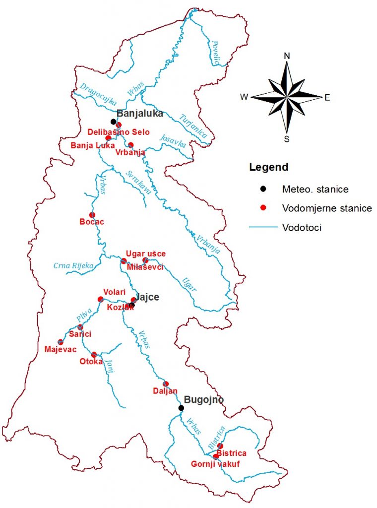
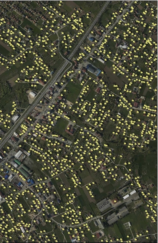
In parallel and as important as data collection and processing of the basin hydrology there was geodetic prospection and surveying of the entire valley area on Vrbas river basin performed with most important tributaries where historical floods were registered. Surveyed cross section profiles of the Vrbas streambed and tributaries in combination with LIDAR surveying of c/a 330 km2 of valley area along the main watercourses enable establishing hydraulic “continuous” model of Vrbas river from the mouth into Sava to the start of hydraulic analyses with most important tributaries.
Such continuous and referenced hydraulic model in combination with results of hydrological modelling and statistical analyses of basin used unsteady flow as entrance limit conditions, and it enables follow up of flood wave propagation and reaction of individual parts of the basin on extreme precipitations of range of occurrence of 1/20, 1/100 and 1/500.
Hydraulic model served also for reviewing existing flow curves on water gauge stations on Vrbas river, but also pointed out to necessity of water level measurement and discharge in flood water periods providing newly identified Q-h curves verified in the next period.
Regarding previous conclusion the hydrological model presented breakdown of status, base for further activities in the sense of verification and improvement as well as general directions toward improvement of monitoring on Vrbas river basin in B&H, especially the need of introducing additional automatic gauge stations, especially in Republika Srpska.
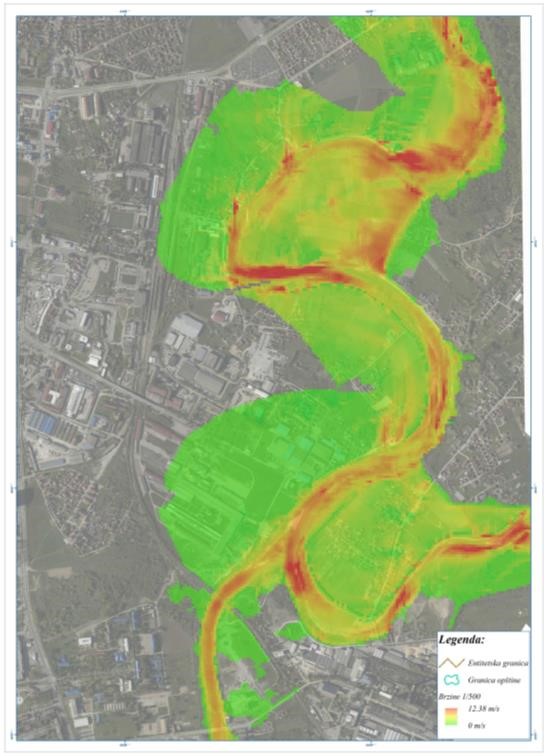
After development of hydrological and hydraulic model, preconditions for flood hazard maps were created, depending on range of occurrence of floods, its volume, depth and flood wave velocity. One of the key advantages of this project is registering velocity vector of the flood wave for each spot of the flood polygon by applying 2D hydraulic modelling.
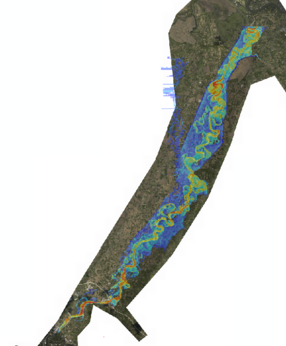
Consequently, the hazard factors for each point of the flood polygon were more credibly presented compered to situation when average profile velocity was used or simply just flood depth for presenting the flood hazards (as it was case in over 20% of EU members).
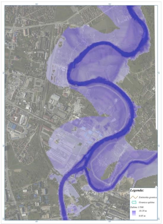
Developed flood hazard maps in combination with socio-economic circumstances on Vrbas river basin represent two basic components of developed flood risk maps.
Developer has received complete base of socio-economic status of river basin (population, economy, protected areas, cultural and historical monuments and IPPC plants) from the Investor UNDP
Quality and volume of socio-economic data were on satisfactory level, especially considering data collected in the wider belt compared to the 500-year flood wave reach (there are no areas under the threat without flood risk being analyzed). Over 40.000 attribute data enabled implementation of quality prospection of all social and economic circumstances each six years (mostly due to social activities in potential flood area, but also due to changes in hydrological and hydraulic regime) this project offered solid base, which should be continuously upgraded and supplemented by input data on flood risk.
Project gave review of the other elements closely connected with the flood risk maps development such as:
- Exploitation of the river material and sustainable river bed management. For the area of Republika Srpska, the Updated Erosion Map was developed (Zavod za vodoprivredu, Bijeljina 2015). Updated map of erosion defined the erosion processes and expected sediment production per watercourse sections on Vrbas river basin, Republika Srpska territory. It will be necessary to develop such document for the Federation B&H as well. This will create realistic assumptions for development of planning documentation about foreseen removal of sediment from watercourses depending on level of erosion, as well as distinguishing torrential river basins. Within this Report, based on the agreement with UNDP expert, the layout map with indicated river material exploitation locations was presented in digital format for the entire Vrbas river basin. Beside data on sediment production, the data about extracted sediment quantity on annual level especially for the downstream part of the watercourse where sediment is disposed intensively and due to this process river beds are being moved. Exploitation locations has to be identified by plan based on the relevant indicators so that minor bed is of required discharge capacity.
- For the next phases, especially for the next updating of the flood risk and flood hazard maps, it is necessary to pay adequate attention to natural disasters caused by extreme earthquakes causing huge damages on dam objects and flood wave propagation. In this project we have collected data on dam construction and geometric features of barriers and accumulations, with the target of reviewing useful volume and possible balance impacts to the flood wave retention within accumulations.
- Developers recommend that analyses of indicated status caused by dam breach serves as the base for upgrading this project, and note that existing Operating manuals for HPP should be integrated into Flood risk management plans, and on this basis to define actions of HPPs in flood events.
- For interpretation of flood damages on Vrbas river basin, developer had on disposal criteria and practice from developed European members, and on example of damage curve applied in Georgia (material handed over by UNDP expert) but it is evident that criteria appropriate for our conditions have to be defined in future. Damage curve should be established depending on not just flood depths but also velocity value in the flooded area so it is consisted with flood risk and flood hazard maps.
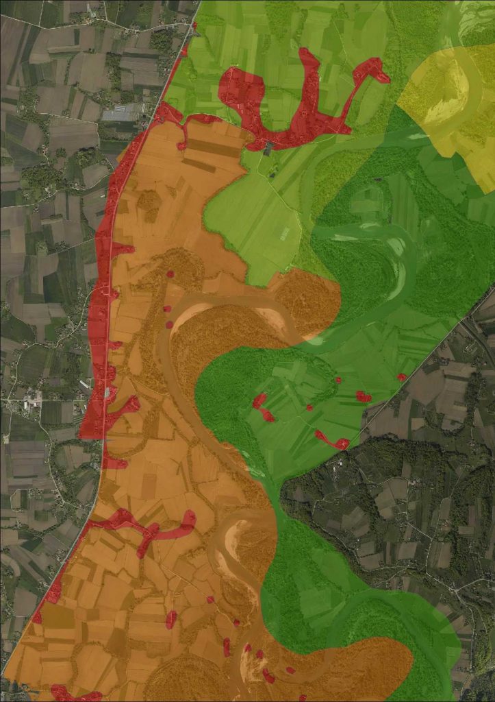
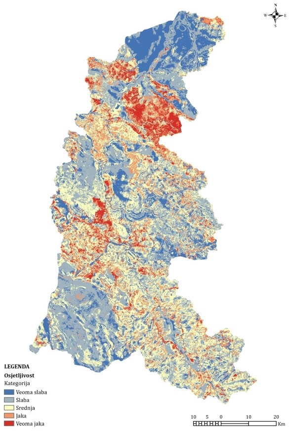
- Having in mind character of floods on Vrbas river basin whose cause are not flooding from the watercourses analyzed in hydraulic model – torrential floods within item 7, Final report and within separate Book 3 Distinguishing the torrential river basins and establishing sensitivity model for occurrence and development of torrential floods in the Vrbas river basin. This segment is extremely important having in mind the continuously increasing torrential trend not just of smaller watercourses but also bigger ones (e.g. 2014 flood events on Vrbanja which had extremely torrential character on certain sections). Also, processes on the basin, erosion-torrential floods-production and transport of sediment are directly dependent to flood hazard coefficient therefore flood risk as well.
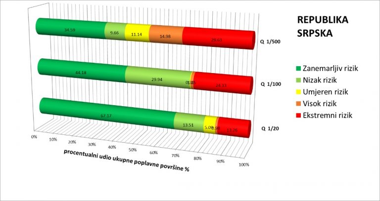
The flood risk on Vrbas river basin were not identified neither for protected areas or cultural and historical heritage. All the attributes gained in this segment of socio and economic circumstances are outside the flood area. Exception is water intake for Banja Luka City from Vrbas which cannot be mapped as risk except in combination with maps of IPPC plants. Regarding plants that can cause incidental pollution and cause waste to spread on wider area based on collected data two such objects were identified (IPPC) on FB&H territory, Bugojno municipality-flooding caused by 500-year flood water. In accordance with this data and EU Directive on floods, interpretation of such case is to mark entire area downstream of IPPC location as “extreme risk” and that was done in the project. Having in mind that downstream of this plant there are accumulations that can significantly “amortize” propagation of this type of pollution, impacts to the downstream sections of watercourse should be subject to the comprehensive expert analyses, especially due to impacts to the open water intake on Vrbas for Banja Luka city water supplying and other sources of water supply from wells which are immediately along the Vrbas river.
Within project there are hydrological and hydraulic models, its further use is left to competent hydro-meteorological institutes, Agency for Water from Sarajevo and PI Vode Srpske from Bijeljina. Use of model should be continuous process that will upgrade and develop models with the goal of gradual establishment of safety against floods in Vrbas basin and on that base, authors of the model will give appropriate support to stated institutions.
Developers note the need of super verification of results of hydrological and hydraulic model, which is going to be preconditioned by collection of hydrological data on basin in the next period, especially under conditions of extreme precipitations and flood wave occurrence. On that basis, the instruction is going to be issued for improvement of automatic monitoring on rain gauge stations and water gauge stations hourly, especially for the area of Republika Srpska where most of the Vrbas river basin is located.
This project can serve as realistic and quality base for upgrading model of flood wave prognosis, flood management in real time and base for appropriate management of accumulations and hydro power plants in Vrbas river basin. Also, project manifest its use value also in prevention and flood protection on marked flood area in basin, for development of the early warning system which is going to be simultaneously implemented with flood forecast model.
Key contribution of the document should reflect in planning and design activities on the basin, since it should be base for development of the design and planning and spatial documentation on the basin, reviewing prevention and estimation of flood damages, along with establishment of protection measures in the area with flood risk, as practiced in EU countries.