


Study “Hydrological Analyses of Cernicko polje”
MH Elektroprivreda RS, ZP Hidroelektrane na Trebišnjici, Energoprojekt –Hidroinženjering ad. Beograd
During 2021 Contract was signed between MH Elektroprivreda of Republika Srpska (Power Utility of Republika Srpska), AC Hydro Power Plants on Trebisnjica from Trebinje and company Energoprojekt-Hidroinženjering a.d from Belgrade on development of financial and technical documentation under title “Preliminary solution of multipurpose dam and reservoir in Cernicko polje”. Energoprojekt-Hidroinženjering a.d. from Belgrade has signed the contract with Zavod za vodoprivredu d.o.o. Bijeljina (Ref.no.148 and D-04-46/21 of 01.03.2021) on business and technical cooperation on development of the Book I: Report – Study on hydrological and meteorological conditions in the area of Cernicko polje. That Book was implemented in period March-June 2021. Implemented analyses actualize role of “Cernička akumulacija” reservoir within Upper Horizons system, which was subject of interest in 70's of the last century, during assessment of hydro power use of transition waters from Gatačko polje in „Cerinca“ and „Fatnica“ Hydro power plants.
HYDROLOGICAL BASIS AND GOALS WITHIN THE PROJECT AREA
General goal of analyses is conceptual review of possibility of storing own water capacities of Cerničko polje, as well as transport and accumulation of transported water from Gatačko polje to Cerničko polje in order to relax the operation of “Dabar” HPP in Dabarsko polje which represents, regarding energy, most interesting, regarding construction most requesting and regarding investments most expensive object of “Upper Horizons” hydropower system.
Due to extremely complex conditions in karst, development of hydrological analyses is significant since it has effects to technical solutions, but also to scenario of transition of water and operational work of foreseen system, especially since this is relatively unexplored area, with significant impacts to inflow regime in both Fatničko polje and reservoir in Bileća.
Goals of hydrological analyses are actualization of hydrological basis for design area respecting dislocation of Mušnica watercourse over Senokos pass towards Malo Gatačko polje, which definitely has impacts to hydrological conditions, especially to the importance of hydrological profile Srđevići. Practically all present analyses of Gatačko polje water balance are based on this profile. For this reason, all hydrological analyses are limited to the “new ones” i.e. current run off conditions in Gatačko polje. It is possible to perform it by application of hydrological model adjusted to current runoff with applying available series of precipitations (from 1961 to 1990 and period from 2007 to 2018). Statistical processing of results, such as runoff toward Malo Gatačko polje, i.e. some of upstream profiles, it will result with statistics of Gatačko polje water balance based on which it is possible to determine parameters of foreseen water transition system toward Cerničko polje and based on that to define water balance for Cerničko polje.
DESCRIPTION OF THE AREA OF HYDROLOGICAL ANALYSES
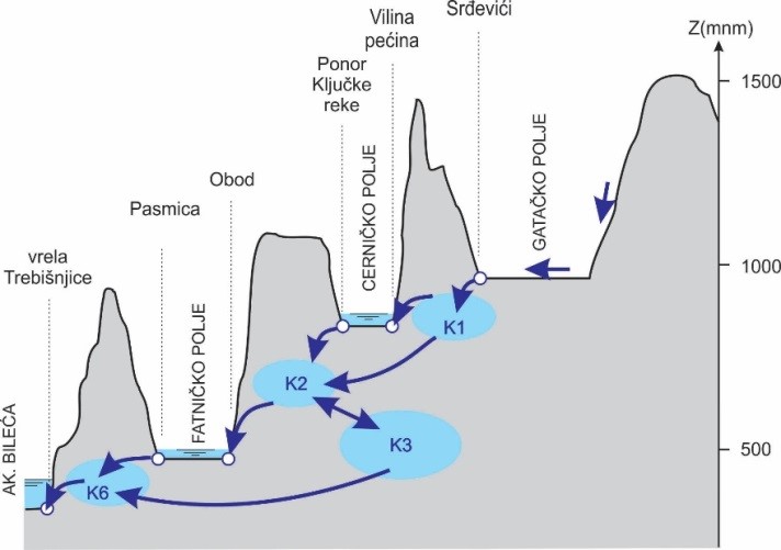
Cerničko polje river basin can be devided to direct and indirect river basin. Indirect part of river basin is Mušnica river basin. Those waters, sinking along the southern part of Gatačko polje, partially and occasionaly under favourable hydraulic conditions originate from Cerničko polje (Vilina cave) and establish Ključka river. Direct river basin covers significantely less area and is limited just to narrow area of Cerničko polje.
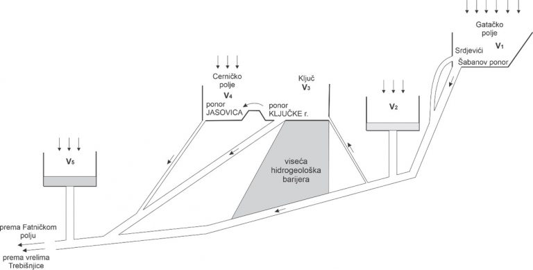
Cerničko polje represents smaller karst field, with the surface of approximately 3 km2. It is located between Gatačko and Fatničko polje, at the elevation of c/a 820 m a.s.l. Cerničko polje is established along the regional reverse faults, where Jurassic limestone lie over Eocene flysch. Depth of the (water bearing) flysch was estimated by geo-physical investigations to be approximately 200 m. In hydrogeological sense, this flysch barrier has a role of hanging hydrological barrier, over which part of the water sinking in Malo Gatačko polje springs to surface and establish Ključka river. Under condition of lower levels in karst environment (under the level of Cernicko polje), almost all waters are filtrating under this barrier toward Fatničko polje and Trebisnjica sources.
In hydrological sense, most important is Ključka river watercourse which is occasionally rising at the exit from the Vilina cave and after approximately 300 m sinks into Ključka river sinkhole. Abundance of the Vilina cave is estimated to over 50 m3/s. During high waters, backwater is being established upstream of the sink, on elevation over 835.60 m a.s.l. There is overflow toward Cerničko polje and sinkhole area, in the area of the Jasovica and Šukovica sinkholes. Other intermittent watercourse of significance is Stepenački stream which is drained toward south part of Cerničko polje. Within the study from 1967, it was estimated that mean daily inflow by Stepenački stream amounts to c/a 0,37 m3/s (1924 – 1964 period of processing).
HYDROLOGIC AND HYDRAULIC MODEL
After analysing data from Jasovica hydrological station and Ključka Rijeka, one could start with establishing and calibrating hydrological model. Namely, data from hydrological stations are valid/available for entre section to the place of backwater, i.e. flooding of the field. For higher waters, hydrological model for identification of balance elements was applied. Model is calibrated based on “older” available data (before the tunnel was constructed) and for the new periods, such as those for which the measurement of the flow through the tunnel exist.
Hydrological models assume systems of mathematical formulations which connect independently variable values of hydrologic system, thus simulating required hydrological processes. In this way it was enabled to, amongst other things, predict system operation under changed, foreseen or designed conditions compared to existing status of the system. Generally, hydrological model is mathematically describing transformation of precipitations (as input) into runoff and new status of hydrological system as output value.
Hydrological and hydraulic model 3DNet-HET was used within this study, for runoff simulation. This model is part of group of physically based, semi-distributed models. It is about model which is gradually developed in last ten years and which was extended to the downstream part of Trebisnjica river basin (Zavod za vodoprivredu Bijeljina and Faculty of Civil Engineering, University of Belgrade, 2020)
In applied model, the calculation of precipitations transformation into runoff is functionally divided into two basic parts, where output from the first represents input for the other. In the first part, vertical water movement is simulated and ground and surface runoff were established. Input for this part are precipitations and meteorological parameters, while output represents values of infiltration toward karst aquifers and surface runoffs on characteristic hydro profiles, such as karst fields. The vertical water balance is calculated as distributed over the entire area of the basin. Other part of the developed hydrological model represents (conditionally horizontal) movement of water in karst environment, via hydraulic connections which are internally connecting knots of the system, i.e. karst aquifers, karst fields and artificial reservoirs. Changes of the level in those knots is described by continuity equation, based on inflow or runoff defined by hydraulic connections. By all means, inflow through hydraulic connection is non-linear function of status/level in knots which are connected. Figures 1-1 and 1-2 present upstream part of the Terbisnjica river basin, with knots and hydraulic connections.
CALIBRATION OF HYDROLOGICAL MODEL AND RESULTS OF WATER BALANCE
For calibration of hydrological model parameters the available series of meteorological data were used. At the same time, results of calculation were compared with observed mean daily data on flows on hydrological stations and levels in fields. In other words, for calibration and testing of model performances, it was necessary to have continuous, simultaneous series of observed precipitations and hydrological values on hydro profiles.
Agreement of measured and calculated values of hydrological values is quantified by calculation of two parameters, using correlation coefficients and Nash–Sutcliffe of this coefficient.
Correlation coefficient is calculated as: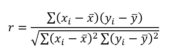
Nash-Sutcliffe-coefficient is calculated as:
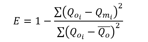
where is observed, and modelled runoff.
Based on hydrological model and additional statistical processing following is defined: