


FLOOD RISK MANAGEMENT PLAN FOR VRBAS RIVER BASIN IN REPUBLIKA SRPSKA
Project “Flood Risk Management for Vrbas River Basin in Republika Srpska”, after the “Strategy of Water Management in Republika Srpska”, is one of the most significant documents in water sector, since represents milestone regarding both planning and operational water management in Republika Srpska. There are several reasons for such assessment of this project’s significance, out of which most important is as follows: Project is the most efficient application of Directive 2000/60/EU of European Parliament on assessment of flood risk management.
This Project creates method pattern for practical implementation of Directive to the other river basins, in accordance with basic Directive targets – flood risk should be analysed, flood maps and risk maps should be developed as well as flood risk plans in order to undertake all necessary measures for mitigating increasing trend of potential flood damages and that it should be harmonized on entire basin, which is basic unit of planning in water management.
- By development of this project and its introduction into practice, very significant phase of water management system cybernetization in Republika Srpska is initiated. It is very thorough methodological but also development change, by which transit from present experience in water management can be made to contemporary management based on simulation and optimisation mathematical models.
- Working on project, huge progress was made on processing hydrological data and its informatics processing, in a way it should be prepared and processed for all basins. Goal of such analyses and informatics processing is that those data can be used for several purposes, out of which most important are as follows: a) use for development of flood hazard and flood risk maps, b) flood risk management plans, c) operational use in period of flood protection, d) as a very important data base in all future upgrading of mathematical models for upgrading management models of the higher class – forecasting, real time management models based on hydrological input assessment, but also for the top management level by application of expert systems.
- Mathematical simulation model for accumulations, which is successfully applicable for testing all managerial decisions during flood wave occurrence – from the moment of forecasting the formation and occurrence of the precipitation cyclone (forecasting for the Europe and BiH is getting more precise every day) over reservoir management during flood water transit, and all the way to the flood wave propagation end and entrance into the normal regime of operation. This mathematical model is thoroughly tested on Bocac reservoir and it turned out that it is very operational (within few seconds it shows what is going to happen if appropriate manoeuvre is applied with flood water release structures) so it can be applied for real time management.
Planning document provided by this Project contains all the areas relevant for long time planning and operational decision making for flood risk management within Vrbas river basin in Republika Srpska. But, significance of this document is quite wider than that, since it provided good general method pattern, for developing such plans for other river basins as well.
Development of the document “Preliminary Flood Risk assessment for Republika Srpska” “Flood Risk Maps and Flood Hazard Maps in Vrbas river basin in B&H” defined causes, scope and other hydraulic and technical parameters of causes and consequences of Vrbas calculated flood waters in the area of Republika Srpska.
Risk of flooding, according to adopted Methodology, was identified and classified by its intensity on Vrbas flood prone area with main tributaries in Republika Srpska. Spatial definition of flood risk within Flood Hazard and Flood Risk Maps, additional basis which were developed within this project (cadastre of torrents and torrential river basins and model of vulnerability to the occurrence and propagation of torrential floods) with existing basis (Erosion Maps, Strategy of integrated management, Irrigation study etc.) has created preconditions to act with plan and goal on entire Vrbas river basin in Republika Srpska, with the goal of mitigating flood risk throughout investment and non-investment measures.
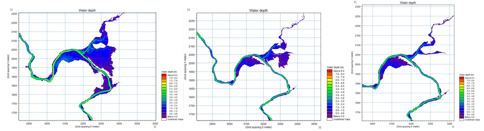
Quality and reliability of Flood hazard and flood risk maps in the Vrbas river basin (Figure 1) was provided through:
- Development of hydrological model for entire Vrbas river basin in Republika Srpska with systematization and analyses of all existing meteorological, hydrological and other maps. Model was developed and verified and with upgrading and modification it can be used within real time flood forecasting model development and early warning system but also during consideration of effects of implemented investment measures,
- Development of continuous hydraulic model of Vrbas river for entire Republika Srpska river basin with main tributaries, using data on non-stationary flow which enabled more detailed interpretation and understanding of process and flood nature for the basin via monitoring of flood wave propagation. Model was developed as combination of 1D and 2D model, in order to determine realistic value of flood hazard for each point of flood prone area (it is product of depth and vector valued flow velocity for each DTM cell) as well as hydrological model, hydraulic model was established so that simple modifications and supplements are enabled,
- Implementation of voluminous socio-economic investigations on flood prone area of Vrbas river with tributaries, with the aim of identifying flood risk for population and economy, i.e.
For implementation of non-investment measure in the segment of sustainable regulation of agricultural and forest land within Vrbas river basin in Republika Srpska:
- Pedological map of the land of Vrbas river basin in Republika Srpska (implemented for the period 2000-2002 through FAO project “Inventory of status of soil resources in post-war period in BiH”
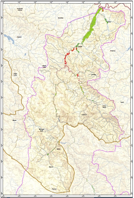
- Map of erosion for Vrbas river basin in Republika Srpska (implemented by Directorate for water – PI Vode Srpske 2006-2014 through the UNDP project on Flood Hazard and Flood Risk Maps for Vrbas river basin in 2017. Map was updated for the wider area of City of Banja Luka, having in mind erosion processes which occurred during floods in 2014 (Figure 2),
- Cadastre of torrential watercourses and basis for the Vrbas river basin in Republika Srpska through the UNDP project on Flood Hazard and Flood Risk Maps for Vrbas river basin in 2017, (Figure 2)
- Vulnerability model for the torrential flood occurrence and propagation (implemented through the UNDP project on Flood Hazard and Flood Risk Maps for Vrbas river basin in 2017) (Figure 3)
- Forest and economic basis and geo-spatial data basis on Forest economies and Forest and economic units and their plans.
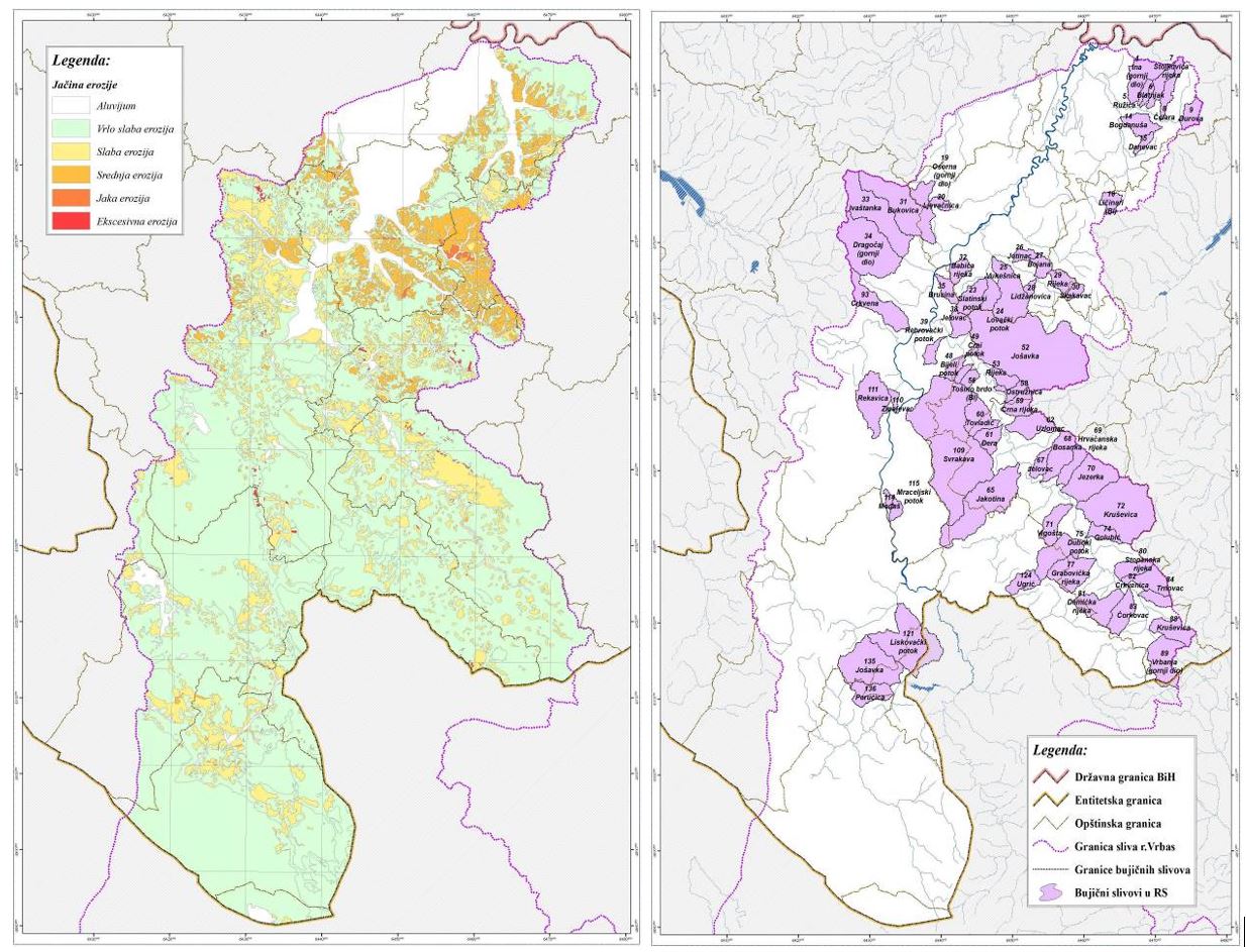
Figure 2 – Layout map – Erosion map of the Vrbas river basin in Republika Srpska and identified torrential sub-basins in Vrbas river basin (drawings for Republika Srpska territory) 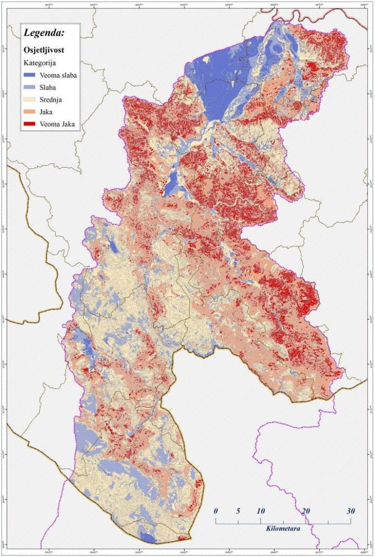
Figure 3. Layout map – results of Vulnerability model to the occurrence and propagation of torrential floods in Vrbas river basin (drawing for RS territory)
Torrential watercourses in Vrbas river basin (territory of Republika Srpska) are unevenly distributed, but it is possible to separate several locations where numerous torrential watercourses occur. In previous investigation in Vrbas river basin (territory of Republika Srpska) there are 137 torrential watercourses separated. Geo-spatial presentation of torrential watercourses in Vrbas river basin on territory of Republika Srpska, is presented via Cadastre of torrential basins.
Plan is processing all the flood risk management problems, which for the transparent and suitable orientation toward individual beneficiaries are divided into separate volumes, annexes, while the Summary Report presents important conclusions, for the highest decision making levels in Republika Srpska and entire water sector. At first there is the most condensed overview of issues considered in individual annexes. Annex 1 presents legal and normative framework for the Plan development. All the relevant legal documents are considered, documents processed at the level of decrees, as well as international documents which are in power and as such obligatory for decision making regarding flood risk management plan. In this summary report, section 3, there will be summary of most important legal documents, frameworks and actions, systematized in a way that it is arranged for all subjects to which those provisions refer to. Annex 2 is extremely important it refers to hydrological and hydraulic analyses and data basis which are important for flood risk analyses on the flood prone area. Annex processes, in a modern IT based and systematized way for public use, meteorological and hydrological data of importance for all further management model development phases in water sector, Figure 4.
Analyses of precipitations are very important, probabilities of flood water occurrence, as well as regional flood water analyses. For the use in management, entire range of flood waves’ probability of occurrence have been identified. There is digital model of terrain elevations and mapping the terrain use, and it is extremely important for all further decision making in flood risk management. In the block of hydraulic analyses there is geometry model of Vrbas and tributaries, flow boundary conditions, and very important results of hydraulic calculations of backwater lines along the watercourse level for the occurrence of flood waters of certain probabilities of occurrence. Hydraulic 1D and 2D analyses was performed and analyses of most important flood areas after implementation of suggested protection measures, from the point of view of achieved protection level, Figure 5.
Analyses, data basis and digitalized cartographic attachments in this annex create precious basis not just for this phase of analyses- flood risk management, but for the all other phases of management model improvement, all to the expert systems, as highest phase of water management. Annex 3 process investment protection measures on flood prone area in Vrbas river basin and is very important for decision making of individual investment decisions. Key indicators of flood hazards and flood risks are considered within it and systematized for municipalities and for the City of Banja Luka. Based on this, already implemented investment measures are presented and their effects to flood risk mitigation. Central part of the annex are proposed measures for flood protection, presented by the municipalities in details, and systematized to existing objects (that should be maintained), investment measures that should be considered in design. In order to develop economic analyses, there are approximate Bill of quantities of protection measures and analyses of effects of those measures, regarding the level of risk mitigation by the size of prevented (avoided) damages they cause.
Thanks to the very good initial base and numerous project implemented in last few years (UNDP-BiH, Ministry, PI Vode Srpske, local communities) good preconditions have been created for considering investment measures on flood prone areas. Due to spacious design area, scope of activities and significant fond of information that are collected in first months of Plan development, analyses of invest measures on the Vrbas river basin in Republika Srpska are developed based on updated geo-spatial data base (data and basis on flood risks and flood hazard, hydraulic calculation of existing and status after implemented investment measures, existing flood protection objects, available design and other documentation, processed preliminary technical solutions which are considered in this Plan, multi-criteria ranging with priorities, approximate bill of quantities etc.).
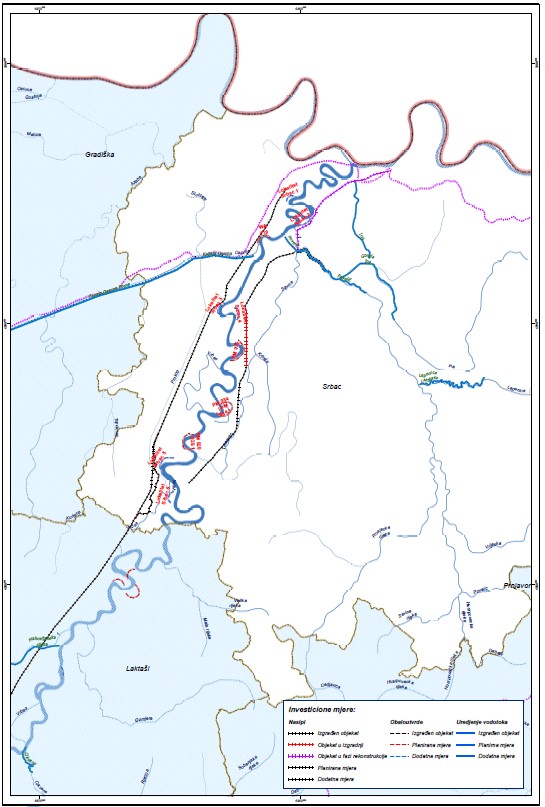
Suggested investment measures covered significantly larger scope of analyses compared to planned ones by terms of reference. With great engagement of the developer, PI Vode Srpske and local communities have showed interest to process also smaller watercourses in local communities by this systematic and integrated approach. Plan covered all, up to now, registered flood prone areas. Measures are planned on the level of flood prone areas and according to local community they belong (figure 6).
Foreseen investment measures on I and II water courses category, but also on smaller watercourses as well, will generally give targeted technical answers regarding flood risk mitigation and in combination with measures of agricultural and forest land organization, anti-erosion works and active management over accumulations, Flood risk management plan for Vrbas in Republika Srpska has offered technical solutions and strategic directions important for gradual mitigation to the acceptable level on considered design area.
Plan foreseen that investment measures are distributed by priorities into three categories as follows: I category – Urgent measures; II category – short term measures and III category – long term measures.
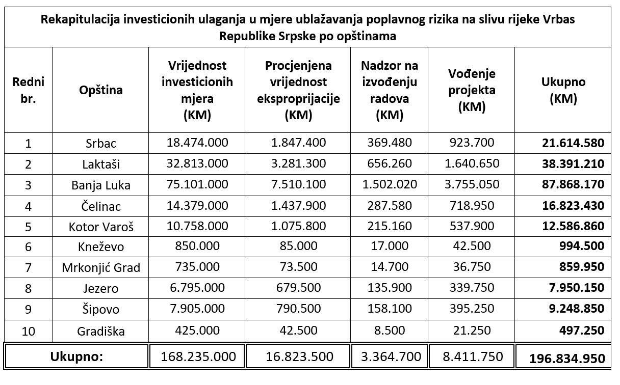
Having in mind quality base for Final design and solid technical level of processing Preliminary technical solutions by approximate bill of quantities within the Plan, it was identified that for implementation of investment measures within Vrbas river basin in Republika Srpska, it takes approximately 170×106 BAM. Costs of development of design documentation approximately amount to 2.6 %, supervision 2%, project management 5% and expropriation 10% of estimated investment.
Foreseen investment measures on Vrbas river basin, for which there is developed designed documentation at the level of Final design considered 11 measures in total with necessary financial investments for flood protection on territory of 5 municipalities. Those investment measures define necessary investments of approximately 70 ×106 KM or 41%, of totally estimated needs for investments into measures for Vrbas river flood protection mitigation in Republika Srpska.
Based on multi-criteria ranging, preliminary list of priorities was created (urgent measures, short term measures and long term measures) for Vrbas river basin in Republika Srpska and local communities – municipalities/towns within river basin. Multi-criteria ranging covered technical, economical, but also development and social parameters of ranging with the aim of respecting needs of smaller, mostly underdeveloped local communities.
Analyses of priorities was defined for implementation of urgent investment measures of flood protection of Vrbas river in Republika Srpska, it is necessary to provide 91,6 ×10⁶ BAM and it is approximately 61% of the totally defined financial investments for reconstruction and upgrading of flood protection system. This data illustrate also present “vulnerability” of population and economy based on Flood risk and flood hazards on Vrbas river basin in Republika Srpska. Short-term flood protection measures, which also should be implemented in short period, require estimated investment of 38,6 ×10⁶ BAM or 26% of total estimated investment measures for mitigating flood risk on Vrbas river basin in Republika Srpska.
Long term measures include investment measures, whose implementation would complete and bring flood protection to acceptable level for Vrbas and tributaries. Estimated financial investments for this category of investment measures equals to 20.1 ×10⁶ BAM OR 13% of total estimated investment measures for mitigating flood risk in Vrbas river basin in Republika Srpska.
Based on investment measures, needs for investments were considered (table 3) as well as priorities for which it is necessary to develop strategic estimation of implementation at the level of competent institutions of Republika Srpska, considering the fact that the investment is substantial.
Annex 4 covers analyses of non-investment flood protection measures, which are extremely important, since the aim is to achieve impacts just with planning measures and improved sustainable management, first of all to stop increase of flood damages and later to its mitigation during implementation of flood protection systems. Annex 4.1. Considers sustainable management and regulation of agricultural and forest land. Proposal of protection measures for areas under the threat of erosion in Republika Srpska, where flood protection goals are implemented in economic and development way. In a part regarding agricultural land first step is to analyse status of agricultural land in Vrbas river basin and then to reconsider sustainable and most acceptable use and regulation of land outside of flooded areas, as well as measures of its regulation and protection.
Within anti-erosion works, it was foreseen to organize sustainable management of agricultural land, for agricultural plots which have active role in agricultural production, for slopes over 8% it was foreseen to have planning approach of gradual regulation. Figure 7.