Study ‘Assessment of the state of ichthyofauna in the Bileca and Trebinje Reservoirs and Plan for Protection and Sustainable use’
Investor: MHC ‘Elektroprivreda’ RS, SC ‘Hidroelektrane na Trebisnjici’, Trebinje
Implementation Period: 2013
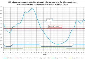
The key attribute of the Trebisnjica System is its integrated multi-purpose character, which enables achievement of a complex structure of goals. In ...
PROJECTS
Flood Risk Management Plan for the Vrbas River Basin in the Republika Srpska
Investor: UNDP – B&H
Project developers: Consortium of the Institute for Water Management Bijeljina & Institute for Hydraulic and
Environmental Engineering of the Belgrade Civil Engineering Faculty
Implementation year: 2018-2019
After the ‘RS Water Management Strategy’, this project is one of the mo...
Amendment to the Erosion Map, Development of the Torrential Basins Register and the Torrential Flood Susceptibility Model for the Vrbas River Basin
The data from the Report on Climate Change Impact in the Vrbas River Basin show that by the end of the century we can expect higher air temperatures and more days with precipitation greater than 20mm. This can produce extreme flow rates and greate...
Research, Monitoring and Data Processing to Determine Environmental Flow Downstream of the HET 2 Dam
The aim of this Study is to adapt to the needs of the population in the region through the use of water for electricity production and the provision of clean water for water supply with maximum care for the environment. In particular, water related projects should improve ecological status (thr...
Study ‘Assessment of the Environmental Flow of the Drina Downstream from the Visegrad HPS in an Urban Section in the City of Visegrad’
This Study defines environmental flow (EF) appropriate to this particular system and observes the EF with detailed adaptation to hydraulic, climate and ecological conditions of this river section of the Drina, particularly through the urban area of Visegr...
Flood Hazard and Risk Maps in Bosnia and Herzegovina – Annex for the Trebisnjica River Basin District in the Republika Srpska
The Project Consortium of Bijeljina’s Institute for Water Management (IWM) and the Institute for Hydraulic and Environmental Engineering of the Faculty of Civil Engineering in Belgrade were tasked to develop flood hazard and flood risk maps for the Trebisnjica Ri...
Preliminary and Detailed Designs Increasing the Capacity of the Trebisnjica River Channel in the Urban Area of the City
(Institute for Water Management, Bijeljina, 2021)
The ‘Trebisnjica’ hydrosystem (HET) is one of the largest and most complex integrated water management systems in Southern Europe and is the largest development project in Eastern Herzegovina. The main facilities are Bi...
Resource Document on Monitoring of Waters and Data Exchange for the Drina River riparian countries
In November 2019, Zavod prepared Resource Document on Monitoring of Waters and Data Exchange for the Drina River riparian countries. This document is a part of the on-going “Drina Nexus follow-up project”, implemented by the United Nations Economic Commission for Europe (UNECE) and funded...
DEVELOPMENT OF HYDRAULIC STUDIES AND MATHEMATICAL MODELS FOR THE GRADISKA WATER SUPPLY AND SEWERAGE SYSTEM WITH A DEVELOPMENT PLAN
The development of a key strategic document relating to utility infrastructure (‘Development of Mathematical Hydraulic Model for the Gradiska Water Supply and Sewerage System with a Development Plan’) was made during 2019 by the Project Consortium consisting...
FLOOD DEFENCE OPERATIONS PLAN FOR THE TREBISNJICA RIVER BASIN DISTRICT IN THE REPUBLIKA SRPSKA
Protection from detrimental effects of water includes activities and measures to reduce or prevent risk to people and property and minimize consequences.
This includes protection against floods and ice on watercourses, erosion and flash floods, and measures to eliminate the consequences of sudden po...
DEVELOPMENT OF THE DETAILED DESIGN FOR THE CONVEYANCE OF WATER FROM ‘DABAR’ HPS AND DRAINAGE OF DABARSKO POLJE WITH ALL PREPARATORY WORKS
The Preliminary Design for a canal in Dabarsko Polje to convey water from the Dabar HPS and from the Polje analysed hydrological, hydraulic, technical/technological and spatial-planning aspects that are important for the design of this multipurpose structur...
PRELIMINARY DESIGN FOR THE IMPROVEMENT OF THE WATER REGIME AND RIVER CHANNEL OF THE VRBAS THROUGH THE URBAN AREA OF THE CITY OF BANJA LUKA
The document ‘Flood Hazard and Flood Risk Maps for the Vrbas River Basin in B&H’ defines the causes and extent of floods by computed flood flows of the Vrbas in the City of Banja Luka, as well as the necessary measures for rehabilitation, reconstructio...